A Quick Hike Along the Niagara River

Niagara Falls rightly gets most of the attention from visitors to this corner of New York. The Niagara Falls State Park is the oldest state park in the United States and looking around I’m grateful for those who preserved this area from souvenir shops, off track betting, casinos and parking garages that would otherwise grind right up to the edge of the falls. Americans need to be protected from themselves and state and national parks are one way to keep the wolves at bay.
I’ve visited Niagara Falls half a dozen times in my life and appreciate the power and beauty of the falls every time I see them. I’ve seen the whirlpool from the Canadian side but that’s akin to walking on the boardwalk at the beach. You see similar stuff but you don’t get any sand in your shoes. There’s an elevator on the Canadian side. Taking an elevator is not my idea of getting outdoors. So with that as my experience with the Whirlpool, I’d never thought much about going downstream on the American side until a friend raved about it. I found an opportunity to do that hike yesterday afternoon after meetings in nearby Tonawanda (To the Native American tribes who lived in this area Tonawanda meant “swift waters”, today it means “land that the power lines run through”)
Whirlpool State Park and Devil’s Hole State Park are the next links in the chain of state parks that line the Niagara River downstream from the falls. Opened in 1928 and 1924, respectively, they each remain largely what they were at that time and thus have that old park nostalgic feel to them. Massive old trees line the upper trail that hugs the cliff line. Old stone staircases, recently rebuilt, are largely the same one’s from when the parks opened. Descending the staircase at the Whirlpool State Park you can hear the white water well before you reach the bottom of the stairs. Glimpses of fast moving green and white water greet you through the trees as you make your way down. As I descend I’m mentally calculating how many of these steep steps I’m going to have to climb back up on my return.

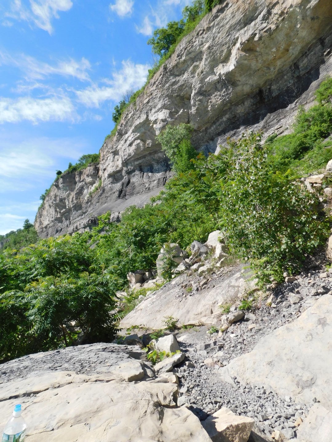
At the bottom you have the choice of left for upstream or right for downstream. I took a left and followed the Whirlpool Trail. This trail follows the river to the wild whitewater that flows from the falls upstream. It reminded me a lot of the Colorado River in the Grand Canyon. Steep cliffs with rock falls, arid climate with a powerful, fast-moving river next to you. It was late afternoon on a weekday, so I was passing people hiking the trail but never felt like it was too crowded. A few college kids were sunbathing and smoking pot and doing whatever college kids do to pass a summer day.
The Niagara River just below the falls is 170 feet deep, apparently as deep as the falls are tall. Further downstream the depth at the whirlpool is 125 feet deep. That rise combined with the narrow gorge, some twists and turns in the river and the sheer volume of water trying to muscle its way through this tight channel creates a chaotic white water scene that’s breathtaking. The green water boils into a frothy, bubbling eruption as it roars by. This is first class white water and I laugh when I see the no swimming signs. Swimming in this water would be almost as dumb as standing on the railing upriver to take a better picture of the falls.

The trail running alongside this wild river is rocky and you need to watch your footing in this stretch. Memories of similar hikes in Sagres, Portugal, Camelback Mountain in Phoenix and the side trails of the Grand Canyon came back to me as I worked my way through a few particularly rocky stretches. The overhanging cliffs in the gorge felt very similar to the canyons out west, and the heat of the day reinforced that impression. The Canadian side at the river level is heavily wooded as well, and I could easily see this landscape as largely unchanged from the days before European explorers walked these paths. The only thing that betrayed the changes were crumbling concrete walls and paths from a century ago.
Still, this was the Niagara Falls region and even in this pristine environment the illusion was eventually encroached upon by power boats and jet skis running the rapids, an overhead tram line, zip lines and buildings overlooking the white water on the Canadian side and further upstream on the American side. Pristine beauty is nice and all, but it’s better when you can sprinkle a little profiteering on top. I was thankful there wasn’t a Margaritaville food truck parked on a barge along the path. Maybe they save that for the weekend traffic. Anyway, rather than going to the bridge I decided to turn around before the end of the trail and backtracked to the staircase, where I then continued onwards along the Devil’s Hole trail.


If the Whirlpool trail is notable for the rocky trails and white water, the Devil’s Hole Trail is notable for the cooling shade and relatively flat terrain the trail follows between the river and the escarpment. The path is an old Seneca Indian portage trail, and they fought several battles along this ground trying to preserve that access for themselves. In 1763 a wagon train was ambushed near this spot and 80 British soldiers and settlers were massacred. That story seems to have faded into history.
As you hike the trail you come across caves of varying sizes. One of these caves is called both the “Devil’s Hole” and also the “Cave of the Evil Spirit” as bad luck seems to befall those who go into it. I’m not sure whether that’s true or not, as I wasn’t inclined to do any spelunking on this particular trip. Locals tell stories of rattlesnakes living in the caves but nobody seems to have ever really seen one. If there are indeed rattlesnakes the chipmunks didn’t get the memo.
I hiked up out of the gorge using the Devil’s Hole staircase that delivers you to the parking lot of that state park. This staircase wasn’t as steep as the one at Whirlpool State Park, but got my heart rate up anyway. The escarpment is very steep and the stairs switch back several times on the climb. Reaching the top I followed the Niagara Gorge Rim trail back to the Whirlpool State Park. This trail had some great views of the river and Canada and was wide and flat. A few points along the way offered perspective on the lower trail and the power of the river.

These state parks are a lovely buffer from the beat up poured-concrete roads, tired tourist culture and power infrastructure that make up much of Niagara Falls, New York. The American side doesn’t have the views of the falls that you get on the Canadian side, but it’s still a breathtaking landscape worth visiting. Hopefully some of the billions of dollars New York is putting towards Buffalo reaches the City of Niagara Falls, New York. The city could use a face lift to make it a more attractive destination. But the parks do their part year in and year out. With no charge for parking or entry into the parks, it’s a great bargain for anyone looking for some exercise away from the crowded railings overlooking Niagara Falls. For me, it was a nice way to cap off a week of travel and get some exercise before the long drive home.