Tag: Haverhill

  • A Walk Around the Timeless Kenoza Lake

    Kenoza! O’er no sweeter lake
    Shall morning break, or moon-cloud sail,
    No lighter wave than thine shall take
    The sunset’s golden veil.
    — John Greenleaf Whittier, Kenoza

    Whittier wrote this poem for the dedication for a beautiful lake in Haverhill, Massachusetts that was to be named Kenoza Lake. Kenoza means “lake of the pickerel” in the native Algonquian language, and in 1859 the locals formalized the name. There is irony in Native American place names living on when the people who’s language was being used for those names were swept away, but that’s everywhere in the world. The names always betray the past if you dig deeply enough.

    Whittier was an abolitionist, and likely saw the plight of the Native Americans who once lived here with a sympathetic eye. He once lived just a couple of miles away from Kenoza Lake in a quiet farmhouse. His farm looks very much the same today as it did then. Importantly, Kenoza itself also remains pristine, today a protected reservoir that supplies drinking water to the City of Haverhill. That lends a timelessness to the lake and surrounding land that’s impossible not to feel as you walk the grounds.

    The land has transformed over time. It was once deep forest, became farmland (like so much of America in colonial times) and eventually returned to forest again. That the land wasn’t developed required some luck. Dr. James R. Nichols, a wealthy scientist who made his fortune developing chemical fertilizers, acquired the farmland and set about building a castle for himself on top of a hill with views of three states. He called the place “Winnekenni”, which means “very beautiful” in Algonquian. Walking the property, today maintained by the City of Haverhill as parkland and a natural buffer for the reservoir, feels like you’ve been transported back to another time.

    There is a network of trails throughout the the park, and you can manage a great step count by doing the entire loop around the lake. They range from gravel roads to single track paths squeezed on both sides by abundant undergrowth(including, alas, poison ivy). The trails are well-marked and it’s very difficult to get lost, as you always have the lake to show you your progress. We encountered plenty of walkers, horseback riders and mountain bikers on the trek around the lake, but never felt it was overcrowded. Indeed, on the single track we saw only one other person, a trail runner who quickly distanced himself from us.

    Reservoirs, like graveyards, are time machines back to the days they were established. The lay of the land remains largely as it was then, and offers an opportunity to hear the whispers of history. It’s relatively easy to imagine how this place looked for Dr. Nichols or John Greenleaf Whittier because it’s largely that same place today: timeless, and beautiful.

    Kenoza Lake
    Winnekenni Castle
    The lake is almost always in view
    Local resident
    Very large Bondarzewiaceae fungi enjoying the wet summer
    Single track trail
    One of several memorials in the park
  • A Rock in the Woods

    History whispered from the woods, calling me to find it. A mere rock this time, set in place to forever mark the border between two agreed-upon places, as settlers tended to do. This one, they say, was set here in 1741, a year after being settled and eight years before Hampstead would be incorporated. The other town, Atkinson, would be incorporated twenty-six years later. That there is a carved A and H on the stone that is a handy indicator that you found it, but neither settlement was known by these names in 1741. Hampstead was known as Timberlane Parish then, and Atkinson at the time was a part of Plaistow, New Hampshire. No, the carving came sometime later. And so did the red paint used to highlight the letters.

    Living on a border town between New Hampshire and Massachusetts, I’m fascinated with these border markers. Some are easier to find than others, conveniently standing aside the road they’ve watched grow over their lifetime. But others are more evasive. And town border markers tend to be less fussy still. When the plowed fields return to the woods they always wanted to be the stones become hidden. And that’s where the fun begins for adventurous history geeks like me. This one wasn’t so hidden; it appears on trail maps for the conservation land it resides in. But ask the 15,000 residents of the two towns where it is and maybe 400 might not give you an odd stare back. The rock isn’t exactly a national landmark like the fictional Plymouth Rock.

    And yet, this tiny rock in the woods marking the border between two towns was set in the heart of the lands the Abenaki once used to stage raids on Haverhill, Massachusetts only four decades before. It would stand witness to the French and Indian War, the Revolutionary War, The Civil War and two World Wars, drawing the settlers from the land that surrounds it to fight for survival nearby and across the globe. And of course it would witness the birth of a nation.

    So sure, it’s just a rock in the woods, but it’s a rock that has seen a few things in its job marking a random border set in 1741 between two settlements in New Hampshire. And I wondered, brushing the snow off it for a better look, how many of those people have wondered at it in that time as I do now? And for how long will it guard this border before such things don’t matter again? I wonder.

    1741 A/H Marker
  • Reflections of the Day

    Merrimack River at Sunset, Haverhill, Massachusetts

    “Water does not act like a perfect mirror. Light objects will appear a little darker and duller in their reflected images and dark objects will appear a touch lighter… A reflection [also] shows you the view from the point on the water’s surface that you are looking at, not the perspective from where you are standing.” – Tristan Gooley, How To Read Water

    I admit, standing on the riverwalk next to the Merrimack River in Haverhill, Massachusetts I didn’t think about whether the reflection was perfect or imperfect. I only thought about the beauty of the reflected light on the dark river water. For why dwell on the science behind the magic? Does knowing the science behind why something happens a certain way make it less magical? I should think not, and neither does Tristan Gooley. If anything it amplifies the beauty. Does knowing the name of the constellations improve or detract from the wonder in the night sky? Clearly it improves the experience. And so it is with water.

    I’ve borrowed How To Read Water from a friend and I chip away at it slowly. In fact, I finished two other books since he handed it to me. It’s not that I don’t want to read it, it’s more that the other books have been whispering to me more persistently. But after witnessing the sunset on the Merrimack River I’m inclined to dive deeper into the book.

    The Merrimack River holds a special place in my heart, flaws and all, because of my time living along its shores, and rowing on its waters, and exploring it from source to sea. Haverhill has never been my home, but I’m drawn to the city for its history and the raw beauty it still displays despite rough treatment by humans for generations. The land and the river both share the same affront from generations of humans, but still the land stoically holds on, scarred but dignified. And the river flows persistently onward, outlasting the generations who abused it. Those generations are eventually buried six feet into the land, becoming a part of it as we all must someday. For all our noisy encroachment, the land and the river silently have the last laugh.

    When you combine the history and the river and sunset, well, you’ve generally got me. And so I lingered along the edge of the river. My old friend and I quietly conspired as the light danced with shadows on her still water, until finally the shadows won out. The day faded and the river transformed into a black ribbon of water that now reflected starlight even as I reflected on another day that quietly slipped into the past.

  • From Pemaquid to Andover: A Tale of Abenaki Revenge

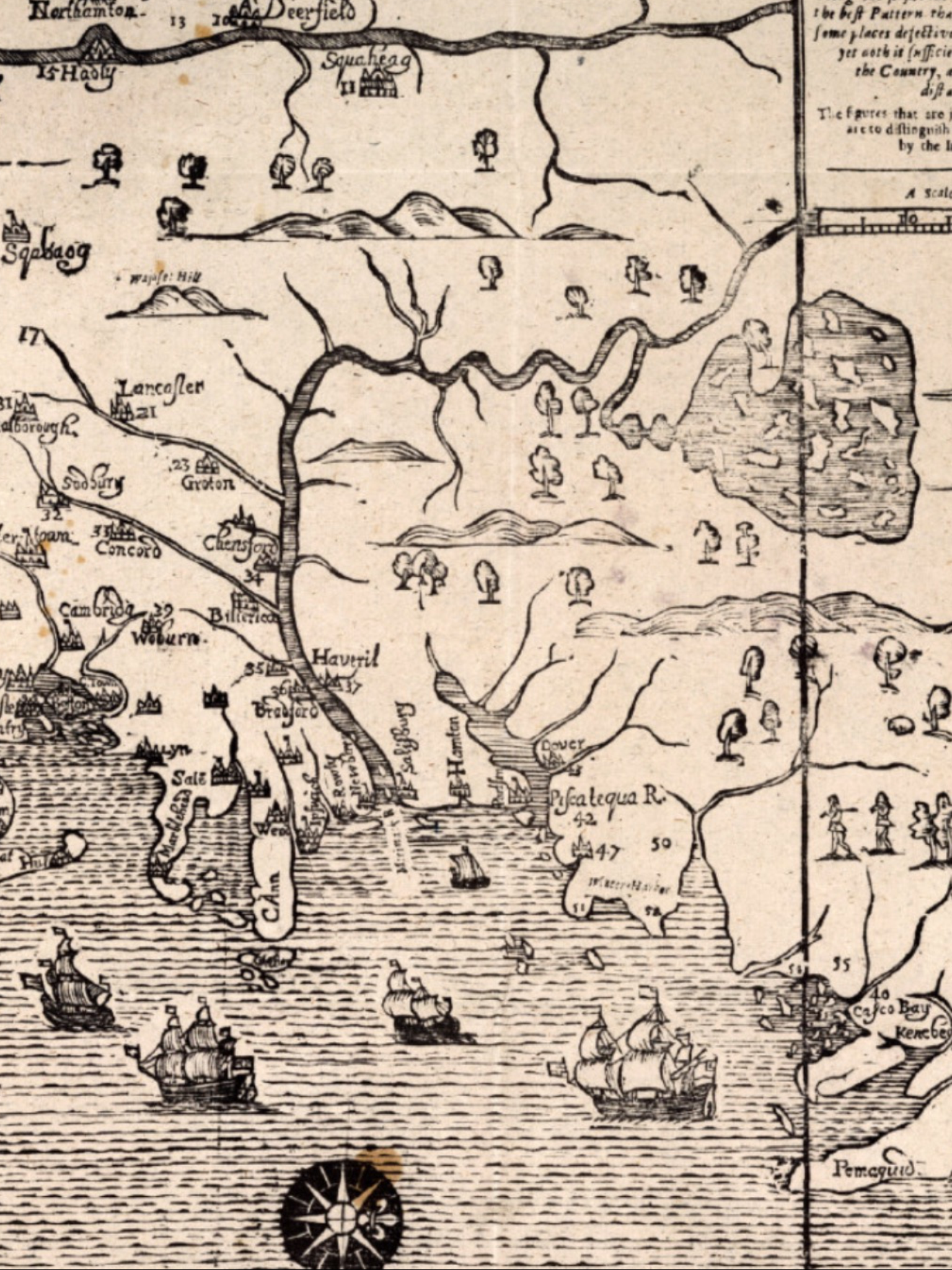
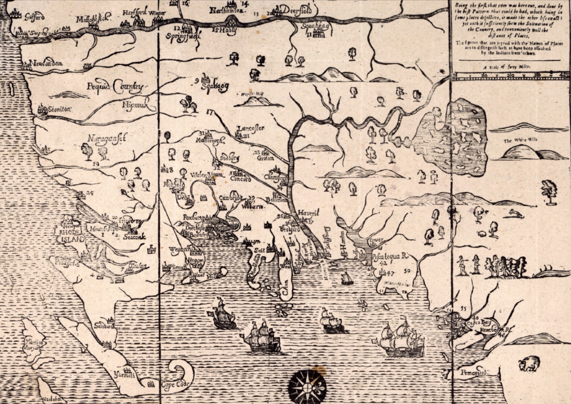
    On February 22, 1698 a group of Abenaki warriors raided Andover, Massachusetts and killed five people and two more (Haynes and Ladd) in Haverhill.  Raids like this were somewhat common in the Merrimack River Valley at that time, as it was the frontier and friction between settlers encroaching on the lands of Native Americans who had lived there for generations was an unpleasant reality for everyone living in this area.  What was particularly interesting about this raid was who they killed, which leads to why they chose this place for a raid in the first place.

    Two years earlier at Fort William Henry in Pemaquid, Maine, Captain Pasco Chubb commanded a garrison of 60 soldiers who were stationed here, tasked with defending this relatively new stone fort from the French and Abenaki who would prefer to have them elsewhere. This site, on a point of land jutting out into Johns Bay at the mouth of the Pemaquid River, wasn’t particularly strategic, but it represented what was meant to be a permanent foothold on the coast of Maine (then part of Massachusetts) and the northernmost settlement by the English. Fort George, A wooden stockade on this spot hadn’t fared well just a few years earlier, so in reconstructing the fort the British stepped in and built it of stone and armed it with 15-20 cannon. It was completed in 1692 and held by a garrison of 60-90 men.

    There were at least three critical weaknesses with Fort William Henry. First, it was isolated and any reasonable hope for reinforcements was small. Second, the small stone and lime walls were not particularly strong, making them vulnerable to the cannon the French would bring. And third, and an unforgivable mistake given the other vulnerabilities, the supply of drinking water was outside the fort walls! So a siege of any length would prove highly effective as water in the fort was depleted.

    Ongoing tensions with the French and Native American population almost guaranteed that a siege would eventually take place.  And Fort William Henry was indeed besieged on August 14, 1696 by 100 French and 400 Abenaki. Prior to the siege, two Abenaki chiefs named Edgeremet and Abinquid went to meet with Captain Chubb under a white flag to inquire about some fellow Abenaki captured by Chubb’s predecessor and shipped to Boston. The goal was a prisoner exchange with the British.  Chubb and his men raised their guns and shot Edgeremet and two of his sons. Depending on the account you read, Chief Abinquid may have escaped. Either way this act of cowardly violence against Abenaki tribal leaders under a white flag enraged the besiegers. They wouldn’t forget Chubb and the British betrayal.

    The Abenaki wrote a letter that demonstrated their rage and feelings of betrayal.  It would set the table for later violence against settlers:

    “Lord who write at to me, listen and understand what I am about to say, аnd write, to you. Thou wilt easily recognize my words, and why wilt them not recognize them. It is thou (so to express myself) that furnishest them to me. Writing with too much haughtiness, thou obligest me to reply to thee in the same style. Now, then, listen to the truths I am about to tell thee of thyself; of thee, who dost not speak the truth when thou sayeth that I kill thee cruelly. I never exercise any cruelty in killing thee, [a*I kill thee] only with hatchet blows and musket shots. Thy heart must have been еvеr addicted to wickedness and deceit. No other proof is necessary than the acts last autumn at Saco and Pemkuit, taking аnd detaining those who were going to obtain news from thee. Never in the universal world has it been seen, never has it been related of a man being taken prisoner who bears a flag [of truce] and goes to parley on public business. This, however, is what thou hast done; in truth, thou bait spoiled the subject of discussion. Thou hast covered it with blood; as for me, I could never resolve to act in that manner, for therein I have even an extreme horror of thy unparalleled treachery. How then dost thou expect that we would talk. What thou sayest I retort on thyself. There, repent and repair the grave fault thou hast committed; seize those who killed me at Saco, and made me prisoner at Pemkuit. I will do the like by thee. I will bring thee those who killed thee when I shall be able to find them. Fail not to do what I require of thee; of this, I say, who killest me without cause; who takest me prisoner when I am off my guard. – Abenaki letter, written by French missionary brothers Vincent and James Bigot, in response to the treachery at Pemaquid

    The French weren’t as surprised, writing in an account of the events that day that “It is to be hoped that the Abenakis will not place any confidence hereafter in English promises.”  

    The English were disgusted with Chubb for quickly surrendering the fort and fleeing back to Boston.  He was thrown in jail for months when he was set free, and only freed when he wrote a petition to the Court.  In it he wrote the following:

    “And whereas ye petition is a very poore man, having a wife and children to look after with by reason of his confines & poverty are reduced to a meane and necesstous condition, having not wherewith all either to defray his prison necessary charges or to relieve his indigent family…”

    Chubb would indeed be released from jail and return to Andover to be with his wife and child.  It was there that a party of 30 Abenaki warriors led by Chief Escumbuit from Big Island Pond would become reacquainted with Pasco Chubb, killing his wife and child, and paying extra attention on Chubb, shooting him several times to ensure he was dead.  Sweet revenge, perhaps, but with the loss of innocents as well.  Chubb has largely been forgotten in the early colonial history of America, and when his name is mentioned it’s appropriately with distain.


  • Jonathan Haynes and a Trip Cut Short

    On February 22, 1698, Jonathan Haynes and Samuel Ladd were returning home from a day collecting cut hay when they were surrounded by a party of Abenaki warriors. Hopelessly outnumbered, they asked for quarter but none would be given for the older men. Both would be killed that day, and one each of their sons captured. One of Haynes’ other sons escaped on a horse. This all happened in what is now Haverhill, Massachusetts near the West Gate Market Plaza.  Today there’s very little evidence of the events of that day, save for a mention on a monument erected by descendants two hundred years later. Those descendants, happily alive at the time, are long gone now too.

    Jonathan Haynes lived a short walk from where Hannah Duston was kidnapped less than a year before.  In fact, Jonathan Haynes had been kidnapped two years before along with four of his children.  Two came back to Haverhill with their father, two lived out their lives in Canada.  This time Jonathan paid the price for living on the edge of the frontier.  The warriors who killed Haynes and Ladd had come from a raid in Andover (likely present-day North Andover) where they had killed five settlers, including Pasco Chubb, his wife and daughter.  Chubb is a story for another day, but it seems that the Abenaki were out for revenge and went to his home in winter to kill him.  Haynes and Ladd were simply unlucky to be on the path that the Abenaki warriors were taking back to what is now Concord.

    There’s a rich history in this region, full of stories like this one that are largely lost to the past. The relentless terror for people living with the threat of raids must have been unbearable at times.  Today there are only whispers.  Evidence of the once powerful Abenaki is almost impossible to find.  But sometimes you find clues to the lives of the original settlers if you simply pay attention.  The Duston Garrison still stands less than two miles away.  And thousands of people drive by the small burial ground where Haynes and his descendants are buried.  Most of the oldest gravestones are illegible as time wears away the engravings on the stone.  The burial ground, like the garrison, is one of the few places in this corner of Haverhill that hasn’t changed all that much in 320 years.  It still marks time as it has since that day so long ago when a trip home was unexpectedly and tragically cut short.

  • The Merrimack River Frontier

    Yesterday I dove deep into the Cape Cod section of John Seller’s Mapp of New England.  Today I’m looking at another fascinating section – the border between “civilization” and the “wilderness’.  I’ve written before about place names like World’s End Pond in Salem, New Hampshire.  Nothing hammers that home like seeing a map from 1675 showing the Merrimack River towns of Haverhill (“Haveril“), Billerica and Chelmsford (“Chensford“) Massachusetts as the frontier towns they were at the time.  North of the Merrimack River is wilderness in this map, South are the growing settlements of Massachusetts.  The river serves a critical role for settlers and Native Americans alike as both transportation and a border.  Settlements at this time were largely along the rivers and their tributaries, the Concord and Nashua Rivers.

    That bend in the Merrimack River northward was a critical point in the understanding of this land.  Isolated outposts like Billerica, Groton and Lancaster represented the outer reaches of people like us.  The map shows Lake Winnipesaukee and its many islands, so there was clearly knowledge in 1675 of what lay beyond, but it remained for all intents and purposes a vast, dangerous wilderness for another century until the fortunes of war, attrition in the Native American population and the shear mass of settlers from Europe turned the tide.

    It’s no surprise that the most notable Indian raids of the day were happening along the frontier.  York, Haverhill, Andover, Billerica, Chelmsford, and Groton all suffered Indian raids during the series of wars between the French and British.  Further west Brookfield and Deerfield had similar raids.  These frontier towns were dangerous places, and the settlers there would rarely venture out to tend their fields unarmed.  Towns like Haverhill were building fortifications and the brick 1697 Dustin Garrison for a measure of protection in the years spanning King Williams War and Queen Anne’s War.

    There were a series of conflicts between the English settlers and the Native American population that impacted northern New England.  In all cases the underlying conflict between the expansion of English settlements and the encroachment on the Native American population was a key factor.  French influence on the Native American tribes also contributed significantly in many of the raids in Merrimack River Valley from 1689 to 1713 as raiders were offered rewards for scalps and prisoners.  Living in this area for most of my life I see many reminders of that time in our history, and I always glance over at World’s End Pond and the Duston Garrison whenever I pass either.  Duston’s wife Hannah was famously kidnapped during King William’s War, her baby and many neighbors killed, marched through the town I live in by Abenaki warriors, and later escaped back down the Merrimack River on one of those raids.

    Wars Impacting Northern New England in the Early Colonial Period:

    • King Philip’s War 1675-1678 (Northeast Coast Campaign vs. Wabanaki Confederacy)
    • King William’s War 1689 – 1697 (French and Wabanaki Confederacy)
    • Queen Anne’s War 1702–1713 (French and Wabanaki Confederacy)
    • Dummer’s War 1722-1726 (Wabanaki Confederacy)
    • French and Indian War 1754 – 1763 (French and Mohican, Abenaki, Iroquois and other tribal alliances)

    So Seller’s Mapp of New England was a living, breathing document that was strategically important to the British and by extension the English settlers living in New England.  If matters were largely settled with the Native American population in the Southern New England areas by 1675, they were anything but settled in Northern New England.  Northern Massachusetts, including what is now coastal Maine and New Hampshire were the literally on edge, looking north and west for raiders.  That they would ultimately overpower the Native American population and New France settlements was not a foregone conclusion at the time.  Another reason it completely fascinates me.

  • Paradise in the Starbucks Drive-Thru

    I was waiting in a Starbucks drive-thru this morning and looking at the house behind it.  Before there was a Starbucks in this spot there was a Mobile station.  Before that?  Probably the yard of the house I was looking at.  Before that?  Probably farmland for a family that owned a larger plot of land in this corner of Haverhill.  Before that?  Probably a few generations of farmers.  And before that?  Perhaps the Duston family, who lived across the Little River, or another family that settled this land.  Before that?  Deep woodland that the Eastern Abanaki inhabited for centuries.

    I wonder now and then what the generations of people who lived on this land would think of it now.  Plunked down in the Starbucks parking lot, they’d be stunned to see the semicircle of cars lined up around the building as coffee addicts and Frappuccino posers each pulled up and completed their transactions.

    They call this part of Methuen Paradise Valley.  The valley today doesn’t measure up to the name.  Don’t get me wrong, there’s some lovely parts of Haverhill and Methuen.  But the spirit of the place, that intangible that prompted some folks a few generations back to name this place Paradise Valley is gone now.

    “Don’t it always seem to go
     That you don’t know what you’ve got til its gone
     They paved paradise
     And put up a parking lot.” – Big Yellow Taxi, Joni Mitchell

    Conservation and preservation are really the only way forward.  I hope people look up from their phones and lattes long enough to realize that.  Or maybe its just progress and I don’t see it.