Tag: Lake Winnipesaukee

  • Making a Splash

    This earth will grow cold,
    a star among stars
    and one of the smallest,
    a gilded mote on blue velvet—
    I mean this, our great earth.
    This earth will grow cold one day,
    not like a block of ice
    or a dead cloud even
    but like an empty walnut it will roll along
    in pitch-black space . . .
    You must grieve for this right now
    —you have to feel this sorrow now—
    for the world must be loved this much
    if you’re going to say “I lived”. . .
    – Nazim Hikmet, On Living

    Skipping along the surface of Lake Winnipesaukee, the hull sliced through the wake of another boat, creating spray that flew off the port and starboard sides, water molecules momentarily flying once again before rejoining the lake. The likelihood of catching these particular molecules of water shining in the sun in their one brilliant moment is exceedingly remote. But we treat it with indifference because it’s something we’ve seen hundreds of times.

    This business of living is a miracle in a cold, indifferent universe. This defiant act of being born and surviving into adulthood, at this moment, on this particular series of trips around the sun for Earth, is an extraordinarily random circumstance. More random than capturing these particular water droplets dancing with the sky. We’re all just randomly formed molecules and energy brought together for our one momentary dance with the universe.

    So what do we do with such information, should we recognize it? Celebrate it? Ignore it? Become overwhelmed by it?

    We might choose to act on it. To embrace our brief moment between the earth and the sky and live. To the best of our ability, while we can. Make a splash in this moment with the sun.

  • Rafting Up on Lake Winnipesaukee

    This hasn’t been a great month in New England for some of the traditional activities of summer. Not a lot of beach days, not a lot of dry hiking days, and not a lot of days when you’d want to raft up with other boats and soak up the sun, casually float in the lake and catch up with people you don’t spend a lot of time with. July 24th was one of the exceptions to an otherwise wet month, and it was an opportunity to take advantage of an invitation to raft up for an afternoon.

    There are 258 islands on Lake Winnipesaukee, each unique and full of stories. I found myself rafted up near Little Bear Island in about 18 feet of water, one of six boats and twenty people each with plenty of stories themselves. I don’t usually slow down enough to enjoy this type of activity very often, but when you’re rafted up on other people’s boats for the entire afternoon, it forces you to chill out a bit and enjoy the moment.

    In a raft up, boats tie on to each other, and at least a couple drop anchors to hold the entire floating island together in one place. With all the rain the water in the lake was higher than normal for the third week in July. It had finally warmed up nicely, making it easy to float for hours in the water, warm up in the sun on one of the boats and then take another plunge when the mood struck you.

    If you like big crowds, people watching and a wilder vibe you might choose to raft up in another location on the lake. There’s an abundance of wilder scenes for the party crowd.. For us, anchoring just outside the channel near Little Bear Island was the best of both worlds. Plenty of opportunities to watch boats motor by in a no wake zone, and of course plenty of chances to ignore the rest of the world and look at the beautiful mountain and lake scenery all around us.

    There are plenty of people who are experts on navigating the lake and it’s many islands, coves, eateries and pubs and history. As a visitor, I had a chance to play tourist on someone else’s boat, experience the lake as a relative newbie and marinate in its waters long enough that it soaked deep into me. A weekend on the lake is just enough to help you see what all the fuss is about. And fill you with memories and anticipation to return again someday soon.

  • The Merrimack River Frontier

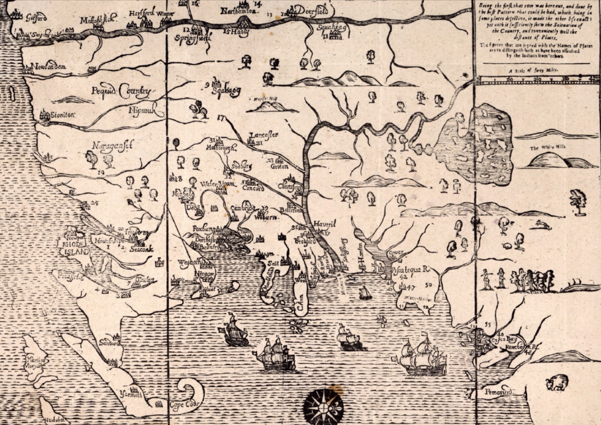
    Yesterday I dove deep into the Cape Cod section of John Seller’s Mapp of New England.  Today I’m looking at another fascinating section – the border between “civilization” and the “wilderness’.  I’ve written before about place names like World’s End Pond in Salem, New Hampshire.  Nothing hammers that home like seeing a map from 1675 showing the Merrimack River towns of Haverhill (“Haveril“), Billerica and Chelmsford (“Chensford“) Massachusetts as the frontier towns they were at the time.  North of the Merrimack River is wilderness in this map, South are the growing settlements of Massachusetts.  The river serves a critical role for settlers and Native Americans alike as both transportation and a border.  Settlements at this time were largely along the rivers and their tributaries, the Concord and Nashua Rivers.

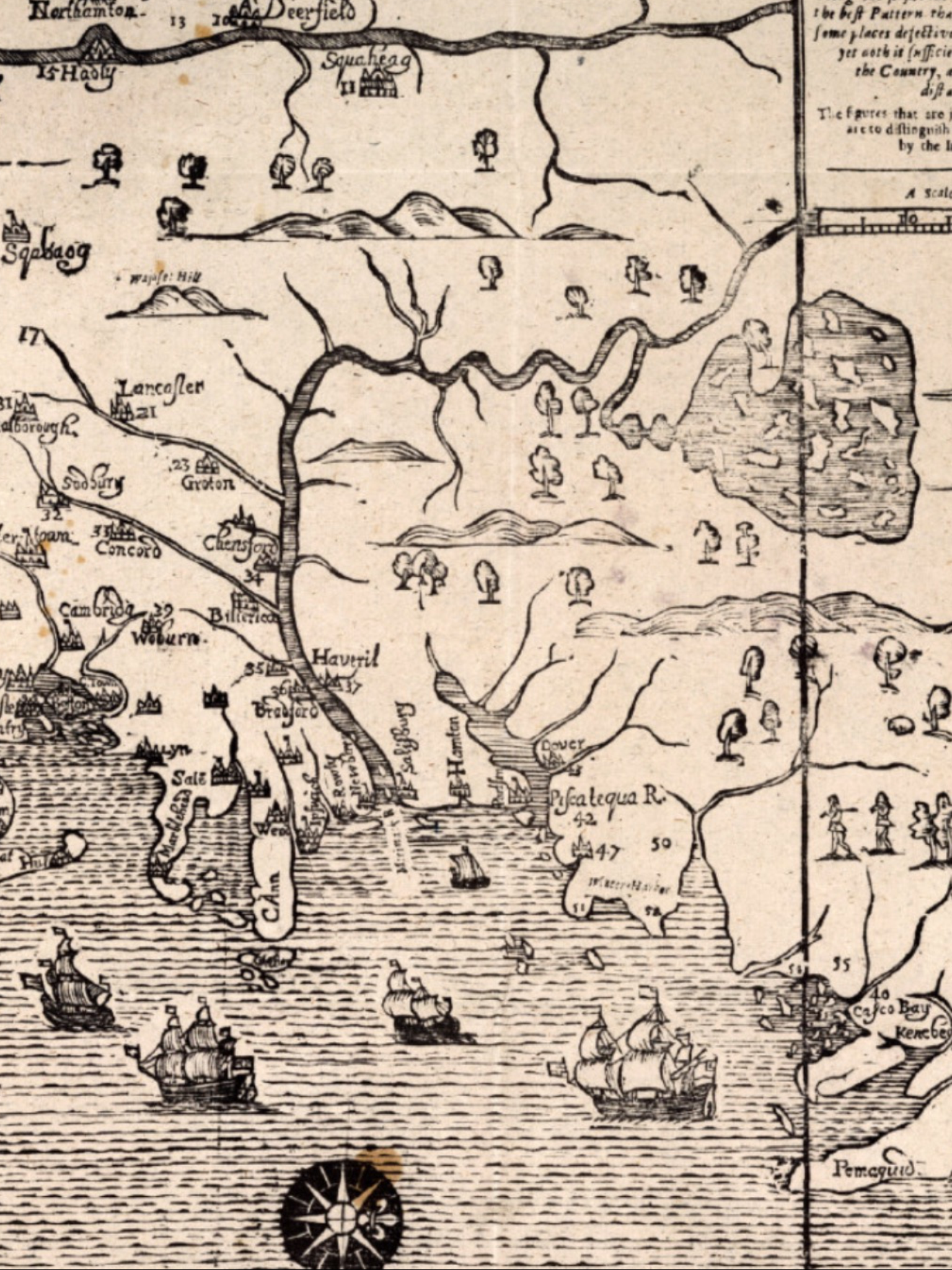
    That bend in the Merrimack River northward was a critical point in the understanding of this land.  Isolated outposts like Billerica, Groton and Lancaster represented the outer reaches of people like us.  The map shows Lake Winnipesaukee and its many islands, so there was clearly knowledge in 1675 of what lay beyond, but it remained for all intents and purposes a vast, dangerous wilderness for another century until the fortunes of war, attrition in the Native American population and the shear mass of settlers from Europe turned the tide.

    It’s no surprise that the most notable Indian raids of the day were happening along the frontier.  York, Haverhill, Andover, Billerica, Chelmsford, and Groton all suffered Indian raids during the series of wars between the French and British.  Further west Brookfield and Deerfield had similar raids.  These frontier towns were dangerous places, and the settlers there would rarely venture out to tend their fields unarmed.  Towns like Haverhill were building fortifications and the brick 1697 Dustin Garrison for a measure of protection in the years spanning King Williams War and Queen Anne’s War.

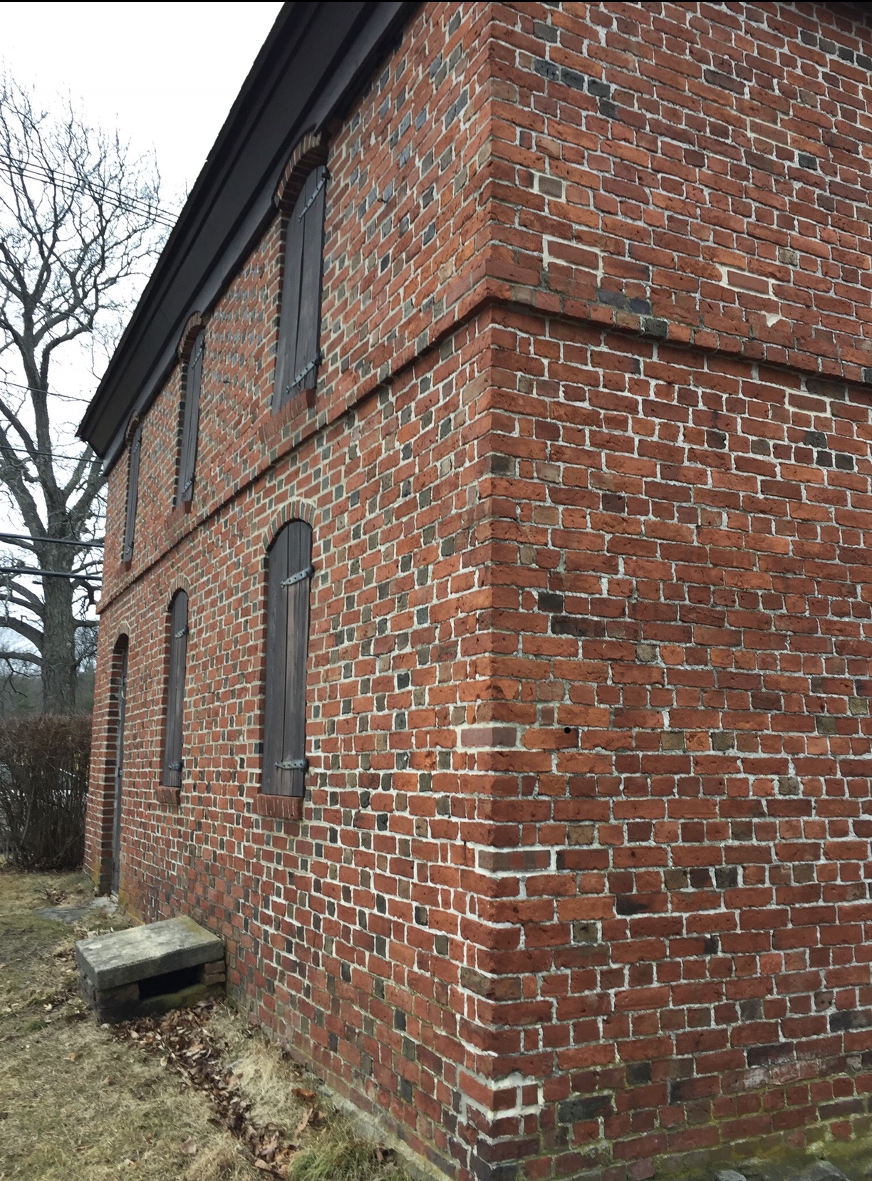
    There were a series of conflicts between the English settlers and the Native American population that impacted northern New England.  In all cases the underlying conflict between the expansion of English settlements and the encroachment on the Native American population was a key factor.  French influence on the Native American tribes also contributed significantly in many of the raids in Merrimack River Valley from 1689 to 1713 as raiders were offered rewards for scalps and prisoners.  Living in this area for most of my life I see many reminders of that time in our history, and I always glance over at World’s End Pond and the Duston Garrison whenever I pass either.  Duston’s wife Hannah was famously kidnapped during King William’s War, her baby and many neighbors killed, marched through the town I live in by Abenaki warriors, and later escaped back down the Merrimack River on one of those raids.

    Wars Impacting Northern New England in the Early Colonial Period:

    • King Philip’s War 1675-1678 (Northeast Coast Campaign vs. Wabanaki Confederacy)
    • King William’s War 1689 – 1697 (French and Wabanaki Confederacy)
    • Queen Anne’s War 1702–1713 (French and Wabanaki Confederacy)
    • Dummer’s War 1722-1726 (Wabanaki Confederacy)
    • French and Indian War 1754 – 1763 (French and Mohican, Abenaki, Iroquois and other tribal alliances)

    So Seller’s Mapp of New England was a living, breathing document that was strategically important to the British and by extension the English settlers living in New England.  If matters were largely settled with the Native American population in the Southern New England areas by 1675, they were anything but settled in Northern New England.  Northern Massachusetts, including what is now coastal Maine and New Hampshire were the literally on edge, looking north and west for raiders.  That they would ultimately overpower the Native American population and New France settlements was not a foregone conclusion at the time.  Another reason it completely fascinates me.