Tag: Massachusetts

  • The Gloucester Fisherman’s Memorial

    “These courageous men have been known by names other than fishermen. They were father, husband, brother, son. They were known as the finest kind. Their lives and their loss have touched our community in profound ways. We remain strengthened by their character, inspired by their courage and proud to call them Gloucestermen.” — from the memorial plaque at the Gloucester Fisherman’s Memorial

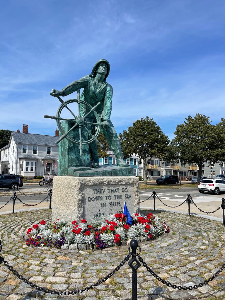
    Gloucester is a small city that sits near the tip of Cape Ann, in Massachusetts. The city is growing increasingly gentrified, but there’s no doubt it maintains its roots in the fishing industry. And when you think of fishing, how can you not think of the Gloucester fisherman? Generations of men and recently women from the community have made their living from fishing. Many went to sea never to return. The Gloucester Fisherman’s Memorial was built in 1925 to forever memorialize them. A few years short of the 400th anniversary of the founding of Gloucester, and the 100th birthday of the memorial itself, I felt compelled to revisit.

    More than 5300 men who left Gloucester Harbor full of hope are known to have been lost at sea. Swept up in Nor’easters, collisions at sea and all sorts of tragedies, whole ships full of fishermen were lost in the unforgiving North Atlantic. Technology makes it safer to go to sea today than its ever been before, but there are still dangers lurking in the unknown. Names are still added to the memorial plaques, but instead of hundreds of names in a given year like 1879, there might be a couple. The most familiar names in recent years were those lost during the “perfect storm” of 1991.

    You don’t get into commercial fishing to be famous, you go to make a living, hoping to return to those you love when your work is done. The memorial itself is modeled after a man named Captain Clayton Morrissey, who died of an apparent heart attack while at sea, years after the memorial had been erected. There’s tragedy in this too, but doesn’t it feel appropriate, that he should pass away at sea? In a way, it makes his image on the statue ring more true.

  • Plymouth’s National Monument to the Forefathers

    Plymouth, Massachusetts might not be the oldest European settlement in the United States, but you can safely say it’s where England got its foothold in America. They might have landed in Provincetown first, hit a few places along the Cape Cod coast as they looked for a better place to settle, and maybe they would have been better off if they’d landed in what would become Boston or Providence, but they landed here. And the great floodgates of immigration began, changing this continent forever.

    That narrative of settlement and conquest is… complicated. But you can make a good case that the Mayflower Pilgrims’ pilgrimage was driven by religious freedom and a desire for peaceful coexistence with the Native American population. They happened to settle in a place where the native population had recently been decimated by disease, making for a bit more elbow room to root themselves in the place, but let’s stay on point. That first generation tried to fulfill the mission as best they could.

    To honor those noble intentions, and to put a spotlight on the best virtues that we humans aspire to, the Pilgrim Society of Plymouth conceived of a huge statue that would dominate Plymouth Harbor. The original monument was supposed to be 150 feet tall and right on the water. Reason eventually took over and they moved the monument to the top of a small hill with a commanding view of the harbor, then shortened it to 81 feet.

    The National Monument to the Forefathers is believed to be the tallest granite statue in the world. There is impressive detail in the carvings and a sense of Victorian optimism about what we aspire to be throughout. The cornerstone was laid in 1850 and the monument completed in 1889. That’s a lifetime for someone in the middle of the 19th century. Throw in the Civil War and violent conflict with Native Americans as the country was settled ever westward and those ideals were challenged even as the monument was being built.

    Today the National Monument to the Forefathers stands in dignified silence, 132 years after the dedication ceremony and a year after the 400th anniversary of the settlement of Plymouth by those Mayflower Pilgrims. That big party got cancelled last year with the pandemic, the narrative of living up to the best of virtues is more challenging than ever as we Americans sort out just who we want to be, but the monument stands. Still waiting for us to measure up.

  • Unattempted Adventures

    “When the first light dawned on the earth, and the birds awoke, and the brave river was heard rippling confidently seaward, and the nimble early rising wind rustled the oak leaves about our tent, all men, having reinforced their bodies and their souls with sleep, and cast aside doubt and fear, were invited to unattempted adventures.” – Henry David Thoreau, A Week on the Concord and Merrimack Rivers

    There’s finally, blessedly, a plan. Places to be, filled with uncertainty and doubt, in the very near future. With one eye on the variants and another on the weather, reservations and bookings complete. There’s new hope for a return to attempting the previously dreamed of. New adventure awaits.

    The moment Thoreau wrote of above took place when he was a young man, before his brother passed away from tetanus, before he wrote Walden or Civil Disobedience. Just a couple of young adventurers waking up along the Merrimack River in Tyngsborough, Massachusetts ready to take on their previously unattempted. It captures that moment of waking up excited and recharged and bursting to get out there and do what you’ve been scheming to do. It’s a more comma-intensive version of my favorite Thoreau quote of all:

    “Rise free from care before the dawn and seek adventures.”

    It should be no surprise to readers of this blog that I’m scheming again. Ready and willing to burst from this big empty nest of a tent and get out in the world again. Big adventures planned for September and October. Micro adventures to fill the gaps, beginning immediately. Room for a pivot here and there, to be sure, but if you don’t plan it and take the leap you’ll just put it off for another day that may never come.

    When you woke up this morning and took stock of the world around you, did it give you a bit of a thrill? If you aren’t buzzing with anticipation, what are you waiting for? Cast aside your doubt and fear and get to it already. Tackle those unattempted adventures.

  • Hurricane Preparations

    The mooring field empties. Only a couple of boats left now, most likely they’ll be gone soon too. Beginning to look like the off-season now. But no, still a few weeks of summer left.

    Summer draws out the furniture, and looking around I know it must be stored safely away today. There’s a calculation that happens in your mind when a storm is coming your way: how much time do we have to do what must be done? Questions around how much traffic will be snaking along to the two choke points off Cape Cod and should I stay or should I go? How high is high enough above the bay should the worst surge occur?

    None of these thoughts are spun up in panic. This isn’t a Category 5 rolling in here, it’s a slow moving Category 1 named Henri with just enough punch to be taken seriously. When you don’t respect nature she’ll eventually teach you a hard lesson. So the boats come out, the neighbors are checked on, the furniture brought in, and the risks assessed. There’s no panic, only calculus and tasks.

    A reverse 911 text alert chirped a warning yesterday. What will today bring? And tomorrow? Tracking west? Less impactful. Maybe. But only Henri knows for sure. The rest of us prepare for the worst and hope for the best. Resilience comes from preparation. And this too shall pass.

  • The Great Falmouth Drop-Off

    Every year, except for last year, I find myself crawling along in a traffic jam just after dawn, patiently waiting for an opportunity to drop off a car full of runners for the Falmouth Road Race. As a committed non runner, it’s admittedly an odd position to put myself in. But we do what we must for those we love.

    The Falmouth Road Race was established in 1973, beginning at one bar and winding seven picturesque miles along the coast to another bar. It quickly became a destination race for a mix of international runners, including Olympians and elite runners, but largely recreational runners of varying abilities. That bit about beginning at one bar and ending at another is an important piece of information. For it means moving thousands of runners from one place to another at the beginning of the day. Which brings us to the great drop-off.

    Runners gather at the Lawrence School in Falmouth for the bus ride to Woods Hole for the start of the race. Runners are supposed to be at the school by 7 AM, which creates a crush of traffic most years as those seeking a parking spot mix with those dropping off runners. Add in thousands of runners walking from local homes and inns and you’ve got a recipe for gridlock as all navigate the local neighborhoods in this small town.

    2021, with a reduced number of participants, lightened the traffic considerably, but it didn’t eliminate it. This is the price you pay for participation in a great race, with both a local and international vibe. For all the madness, everyone is there to have a good time on a summer day.

    After dropping off runners spectators strategically position themselves at key viewing spots. My preferred location gives me a chance to see my favorite runners twice: just after the 6 mile mark and again at the finish. Don’t tell anyone though, it’s already getting pretty crowded here. With COVID considerations addressed, isn’t it nice being around people again?

  • From Fenway Park to Barred Owls in the Night

    Yesterday afternoon I changed up the routine and watched the Boston Red Sox play the Detroit Tigers at Fenway Park. Day games are a different vibe than night games, and all games are a different vibe during a pandemic. But we’re slowly coming out of it, and going to a baseball game on a beautiful day felt pretty cool.

    It’s been decades since I’d seen that many empty seats at Fenway Park. Social distancing requirements demand low capacity, and we were among the lucky few to get in to see the game. Honestly the game was a mess of bad pitching and horrific defense for both teams, with 21 total runs scored. But being back inside the park after a couple of years, and especially the last year, made it special.

    The entire experience, like everything else nowadays, occurs with appropriate precautions. They zip tie the seats you’re not supposed to sit in, and have some ushers walking around asking you to put your mask on if you aren’t eating or drinking. I saw plenty of people breaking this rule, but people are spaced so far apart that it didn’t matter much. The group I was part of is fully vaccinated and more comfortable than we might have been otherwise. No food vendors walking up and down the stairs pitching hot dogs and popcorn, and there were limited options below. But we were still at Fenway Park and loving the afternoon vibe.

    Back at home in New Hampshire and ready to call it an early night, I heard the calls of Barred Owls in the woods behind the house. Loud. Close. And what sounded like three or four owls. We don’t generally have Barred Owls in the neighborhood, mostly because we have Great Horned Owls and they stay clear of each other. But here they were, and the night was filled with the apocalyptic sounds of Barred Owls in the night.

    You can’t just slip away to dreamland when there’s a cacophony of owl calls outside. So I walked outside on the deck and stood listening to them in the dark. High up in the tree canopy, making baby Barred Owls or at least deep in negotiation. I thought about the contrast between Fenway Park and the woods of New Hampshire on this beautiful day in May. I’m not sure what this “new normal” will be, but if this was it, I felt lucky to have been a part of it.

  • A Rock in the Woods

    History whispered from the woods, calling me to find it. A mere rock this time, set in place to forever mark the border between two agreed-upon places, as settlers tended to do. This one, they say, was set here in 1741, a year after being settled and eight years before Hampstead would be incorporated. The other town, Atkinson, would be incorporated twenty-six years later. That there is a carved A and H on the stone that is a handy indicator that you found it, but neither settlement was known by these names in 1741. Hampstead was known as Timberlane Parish then, and Atkinson at the time was a part of Plaistow, New Hampshire. No, the carving came sometime later. And so did the red paint used to highlight the letters.

    Living on a border town between New Hampshire and Massachusetts, I’m fascinated with these border markers. Some are easier to find than others, conveniently standing aside the road they’ve watched grow over their lifetime. But others are more evasive. And town border markers tend to be less fussy still. When the plowed fields return to the woods they always wanted to be the stones become hidden. And that’s where the fun begins for adventurous history geeks like me. This one wasn’t so hidden; it appears on trail maps for the conservation land it resides in. But ask the 15,000 residents of the two towns where it is and maybe 400 might not give you an odd stare back. The rock isn’t exactly a national landmark like the fictional Plymouth Rock.

    And yet, this tiny rock in the woods marking the border between two towns was set in the heart of the lands the Abenaki once used to stage raids on Haverhill, Massachusetts only four decades before. It would stand witness to the French and Indian War, the Revolutionary War, The Civil War and two World Wars, drawing the settlers from the land that surrounds it to fight for survival nearby and across the globe. And of course it would witness the birth of a nation.

    So sure, it’s just a rock in the woods, but it’s a rock that has seen a few things in its job marking a random border set in 1741 between two settlements in New Hampshire. And I wondered, brushing the snow off it for a better look, how many of those people have wondered at it in that time as I do now? And for how long will it guard this border before such things don’t matter again? I wonder.

    1741 A/H Marker
  • In Search of a Border Marker

    In 1622 Captain John Mason was granted the land between the Kennebec River and the Merrimack River and the territory was named New Hampshire. The border with Massachusetts wasn’t the middle of the river, but a distance three miles north of the river’s shore. This made for an interesting, zig-zagging border that meanders along as the Merrimack River has from long before settlement by the English. That’s 398 years of continuous service as the official border between two similar yet completely different states. Barring wholesale changes in the borders that virtual sharp point should remain forever.

    Today, instead of eating lunch like a normal person I drove over to find the sharpest point on the border between Massachusetts and New Hampshire at a spot that on a map looked to be accessible in two directions. Using Google I zoomed in on the satellite image and decided the easiest possible way to get to this point was to walk the maintenance “road” that ran under the power lines adjacent to Route 213 in Methuen, Massachusetts. This worked out well until I reached the place where I needed to head north to the border point and scanned a swampy mess overgrown with cattails and impenetrable brush. This hike turned into a dead end but a good education on the lay of the land.

    Next option was to drive to the town transfer station, which was the next closest public land, to see if I could get to the woods that the border ran through that way. I had a great conversation with the woman weighing trucks in at the entrance, and she was politely curious about the quest that I was on, but received a no-go from the decision-makers on the other end of the radio. Not to be on this day. And that leaves me two options. Find another way in, potentially across private land, or to simply wait for the heart of winter when the ground is frozen solid to attempt the power line route again. I suppose there’s a third option of just dropping this pursuit of a border marker that may not even be there, but tell me, what’s the fun in that?

  • Reflections of the Day

    Merrimack River at Sunset, Haverhill, Massachusetts

    “Water does not act like a perfect mirror. Light objects will appear a little darker and duller in their reflected images and dark objects will appear a touch lighter… A reflection [also] shows you the view from the point on the water’s surface that you are looking at, not the perspective from where you are standing.” – Tristan Gooley, How To Read Water

    I admit, standing on the riverwalk next to the Merrimack River in Haverhill, Massachusetts I didn’t think about whether the reflection was perfect or imperfect. I only thought about the beauty of the reflected light on the dark river water. For why dwell on the science behind the magic? Does knowing the science behind why something happens a certain way make it less magical? I should think not, and neither does Tristan Gooley. If anything it amplifies the beauty. Does knowing the name of the constellations improve or detract from the wonder in the night sky? Clearly it improves the experience. And so it is with water.

    I’ve borrowed How To Read Water from a friend and I chip away at it slowly. In fact, I finished two other books since he handed it to me. It’s not that I don’t want to read it, it’s more that the other books have been whispering to me more persistently. But after witnessing the sunset on the Merrimack River I’m inclined to dive deeper into the book.

    The Merrimack River holds a special place in my heart, flaws and all, because of my time living along its shores, and rowing on its waters, and exploring it from source to sea. Haverhill has never been my home, but I’m drawn to the city for its history and the raw beauty it still displays despite rough treatment by humans for generations. The land and the river both share the same affront from generations of humans, but still the land stoically holds on, scarred but dignified. And the river flows persistently onward, outlasting the generations who abused it. Those generations are eventually buried six feet into the land, becoming a part of it as we all must someday. For all our noisy encroachment, the land and the river silently have the last laugh.

    When you combine the history and the river and sunset, well, you’ve generally got me. And so I lingered along the edge of the river. My old friend and I quietly conspired as the light danced with shadows on her still water, until finally the shadows won out. The day faded and the river transformed into a black ribbon of water that now reflected starlight even as I reflected on another day that quietly slipped into the past.

  • The Old Indian Meeting House

    The Nauset of Cape Cod are part of the Mashpee Wampanoag and were known as the “Praying Indians” because they became converts to Christianity.  They were an important ally for the colonists against tribes that rose up against the encroachment of the English settlements.  Most famously they worked with Benjamin Church as guides in his hunt for Metacom, or “King Philip”.  It was one of the Praying Indians who killed Metacom, effectively ending King Philip’s War in 1678.

    The Nauset were clearly converts to Christianity in the 1670’s, and they met somewhere in Mashpee to pray, but the original building is long gone.  A second building was purportedly built in 1684 at the original site near Santuit Pond.  That building is generally agreed upon as the current Old Indian Meeting House, relocated in 1717 to its current location on Meetinghouse Road (naturally) just across from the Mashpee River. This would make it the oldest church on Cape Cod and the oldest Indian church in the United States.  I’ve read at least one article that disputes the original date of construction for the meeting house, with a local historian claiming the building was actually built in 1757 or 1758 by Deacon John Hinckley.  I believe that Deacon Hinckley is agreed upon as the builder of the church, so determining the actual date should be relatively easy from there.  But I’m not diving deep into this controversy.  There’s no doubt that the Meeting House is historically highly relevant and important.  It was used by the Nauset as a church, and also no doubt that it was here that the Nauset staged a nonviolent protest known as the Mashpee Revolt against the Commonwealth of Massachusetts in 1833 over control of the tribe’s land.  Of course, that was exactly what Metacom was doing from 1675 to 1678, but he chose violence (spurred on by violence against the Pokanoket).

    I visited the Old Indian Meeting House on a quiet, hot August day.  Not a lot of Cape tourists hanging out at an old build next to a cemetery on a perfect beach day. I find that I’m often the only visitor to such places in the moment I’m there. But I prefer quiet time with places of relevance. It’s set on a small hill on the edge of the cemetery, roughly three miles from Santuit Pond, which would make moving it on logs on old colonial roads quite an undertaking.  The Mashpee Wampanoag hold this place as sacred, and I respectfully walked around the site for a few minutes, read a few of the nearby gravestones and generally tried to get a feel for the place before moving on.  A visit to their web site prompts a popup requesting that you sign a petition to help the tribe protect their lands from changes at the Bureau of Indian Affairs.  It seems that the contributions of the Praying Indians are once again being forgotten by some in the endless land grab of the native lands.  That would be par for the course.