Tag: New Hampshire

  • Mystery Hill

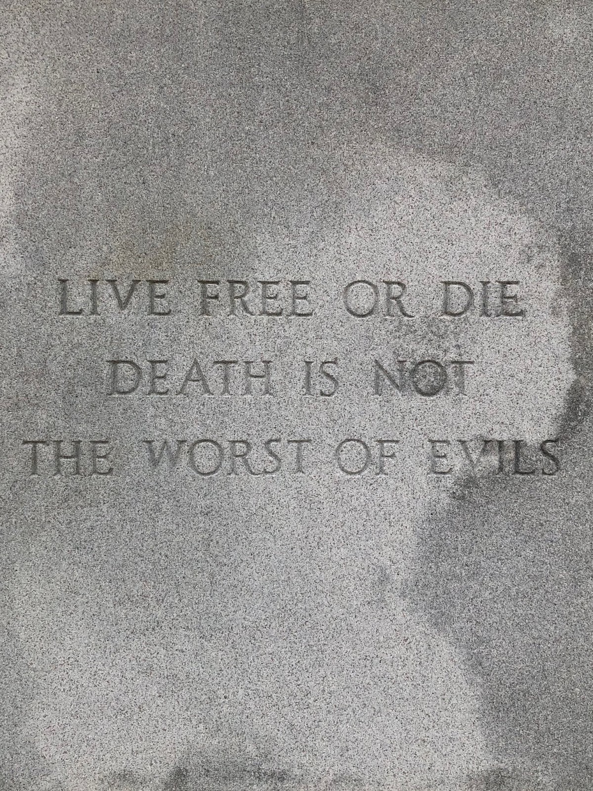
    I live roughly a mile and a half from a place called America’s Stonehenge.  It’s also known as Mystery Hill, and I like that name a bit more because it infers that there’s much about the site that is unknown.

    Here’s a great description of the site from the mysteryhillnh.info web site:

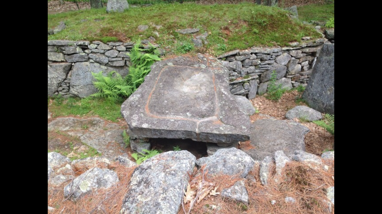
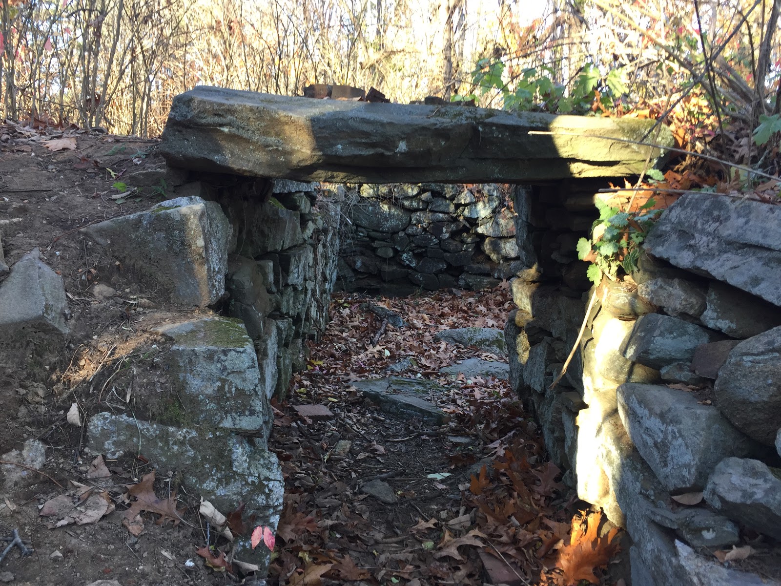
    The Mystery Hill archaeological site, better known today as America’s Stonehenge, is situated on the exposed bedrock summit of Mystery Hill in North Salem, New Hampshire. The site consists of a core complex of 13 stone chambers, several enclosures, niches, stone walls, stoned lined drains, small grooves & basins, and other features which covers about one acre on the summit. Extending outward from and surrounding the core complex, are more stone walls, niches, standing stones, and two procession ways. Along the perimeter of the summit are four confirmed astronomical alignments. Below the summit on the slopes of the hill are a 14th chamber, two utilized natural caves, springs, stone walls, stone cairns, niches, standing stones, and other features. In total, the site covers about 105 acres.

    I’ve lived in close proximity to this site for twenty years.  And yet I’ve only visited it twice – once alone and once with my daughter.  If you’re an archaeological buff, an astronomy buff, or a mystery buff its a great place to visit.  I’m a history buff and like to understand the place I live in.  A large part of that is who lived here before me.  Mystery Hill has carbon dated evidence of people living in this area 7000 years ago.  Native Americans were most likely those people, and they most likely lived in the area well before that.  What we know for sure is that the Native American presence in the region was largely gone for a number of reasons by the time of the French and Indian War.  Colonial settlements continued to nudge further and further north and west and eventually the area because fully colonized, first as Methuen, Massachusetts and eventually as Salem, New Hampshire.

    About ten years ago a Boston television station did a live broadcast at America’s Stonehenge, and the weather person at the time, Dylan Dryer, laid down on the stone table that many people think was a sacrificial alter because of the drainage channels carved into it.  Maybe it was, maybe it was just the place where they cleaned up whatever they brought back from the hunt that day.  Either way, I thought it was interesting that she laid down on that spot.  Apparently there was no bad mojo as she’s now on national television and seems to be doing just fine.

    Look at Mystery Hill from a Google satellite map and the first thing that jumps out at you are the spokes of clear cut trees coming out from the center of the hill.  This was done by the people who manage America’s Stonehenge to provide clear lines of sight on the celestial points that are marked.  Whether this was done thousands of years ago by Native Americans or Celtic visitors or by a farmer in the 1800’s building off what was up on the hill I don’t know.  But I do know it’s impressive to see when you’re standing on the viewing platform.

    The other thing you notice when you look at that Google Satellite map is the encroaching development on all sides.  That’s accelerating with a development eating into the woods to the southeast of Mystery Hill.  I find this disappointing, but not surprising for Salem, New Hampshire.  The town seems to value real estate development and commercial space over conservation space.  But then again, Mystery Hill has been here before with waves of settlers clearcutting and farming the land around it.  And until some developer plugs condos on top of the hill it (wouldn’t put it past Salem) the site will continue to mark time one celestial year after the next.

  • Ulster Scots & Potatoes

    Ulster Scots & Potatoes

    The Ulster Scots settled in New England in 1718.  They weren’t coming here to make their fortune, they were coming for survival.  The Ulster Scots were caught between the British and the Irish when forced to out of their homelands in the early 1600’s to the ancestral homelands of the Irish in the County of Ulster.  Civil Wars and massacres in Ulster threatened to wipe out the population.  Many of these people, seeing no hope for the future in Ulster, migrated to America.

    The Governor of Massachusetts in 1718 was Samuel Shute.  Shute was looking at the ongoing threat from the French and Indians on the fringes of civilization and felt that these immigrants would be a great buffer.  So the Ulster Scots settled in what is today Maine and New Hampshire in great numbers.  The Nutfield Grant brought many of these migrants to New Hampshire in 1719, in what is now Derry, Windham and Londonderry.
    One of the leaders of these Ulster Scots was the Reverend James McGregor.  McGregor is credited with being the first person to plant potatoes in America.  And since he did this in Nutfield, this makes New Hampshire the first place on the North American continent to grow potatoes.  
    Potato crops are still big in New England, but not so much in New Hampshire.  The Granite State’s nickname is a stark reality for farmers.  There’s a reason there are stone walls all over the place here.  The rocky soil makes farming tough for anyone.  When your survival is based on what you grew that season, you’d better start with decent soil.

    Most of the potato farms are in Northern Maine, with more than 55,000 acres of farmland dedicated to potato crops in Aroostook County.  It seems that the farmers are mostly Irish and not Ulster Scots.  The original Nutfield Grant doesn’t have any potato farms that I know of, but they’ll be celebrating their 300th anniversary this year.

  • Arlington Mill Reservoir

    There are two ponds that flow into the Spicket River that helped supply the Arlington Mills in Lawrence with its water.  Each pond has a unique history worthy of a closer look.  Arlington Mill Reservoir, or today just Arlington Pond, and Big Island Pond, which borders Derry, Atkinson and Hampstead, New Hampshire.  Big Island Pond flows into Arlington Pond, which then flows into the Spicket River, which powers the Arlington Mills before eventually flowing into the Merrimack River and ultimately the Atlantic Ocean.

    Arlington Pond occupies 269 acres and is located in Salem, New Hampshire.  In 1919, 100 years ago this year, Arlington Mills purchased the land surrounding and underneath what is now the pond.  The next year they began construction of a 48 foot tall dam, which they called the Wheeler Dam, after the Wheeler Mill that once occupied the site.  In 1923 they completed the dam and filled the reservoir.  In doing so a stretch of Old North Salem Road and the foundations for the original mill buildings were submerged.  That would be an interesting dive site.

    People bought the land around the lake.  According to the Arlington Pond Protective Association, “The land surrounding the lake was owned by Thomas Kittredge, Sr. He owned a coffee shop in Haverhill, Massachusetts and sold parcels of the land to his customers; the lots were nicknamed “Coffee Pot Lots”.” – APPA

    I don’t see Arlington Pond often, but I hear it.  Boats, fireworks, snowmobiles and ATV’s are loud enough at night that the sound travels to where I live.  I’m roughly halfway between Arlington Pond and Big Island Pond.  And while Arlington Pond is much more accessible from a viewing standpoint, I’ve spent much more time on and in Big Island Pond.  Where Arlington has built up around the entire  shoreline, Big Island Pond has a more rural feel thanks to the protected land at Governor’s Island.  But Arlington has it’s charms too.  At some point I’d like to get on the pond and go for a swim there. Then again, you might say that I’ve already swum in the water before it gets there.

  • Slavery in New Hampshire

    Slavery in New Hampshire

    When I think of New Hampshire, I don’t think about slavery.  Frankly, it’s inconceivable to me that someone would enslave another human being, but it was commonplace in all of the thirteen colonies in the 1600’s until 1865, when it was finally abolished after the Civil War.

    But it surely existed here.  In 1767 there were 187 slaves in Portsmouth, New Hampshire.  Portsmouth was a hub for the transport of slaves into North America and human beings were bought and sold right on the same streets we walk today.  There are as many as 200 deceased slaves under the streets of Portsmouth around Congress Street who probably died soon after arriving in the city.  Slaves that died on the transport ships were thrown overboard like garbage.

    New Hampshire wasn’t an optimal location for slaves, not because of a moral imperative, but because the land didn’t support farming using slave labor.  It simply wasn’t as profitable here, but it was still cheap enough to justify the act.  Over time, as the Industrial Revolution transformed the region to a manufacturing hub, cheap human labor used in the factories because the norm.  Slavery was pushed to the south, where plantations made slavery economically viable.

    Looking around New Hampshire, it’s not a particularly diverse population.  Perhaps that lack of slave labor meant that when it was finally abolished there simply weren’t many black people living here.  Perhaps its because when these slaves became freed they congregated in communities elsewhere.  Whatever the reason, New Hampshire remains one of the whitest states in the union.

    I’m not at all comfortable writing about slavery.  I’m not a perfect man, but I’m a free man and I can empathize with those who endured the horrors of slavery.  For all the talk of freedom in the years leading up to and after the Revolutionary War, the colonists of the time largely overlooked the plight of those who served them.  Still, there was a growing revulsion towards slavery, and over the one hundred years from when those 187 slaves were in Portsmouth the Americans reached a tipping point where it was outlawed.  Slavery remains a stain on our history, and it’s important to remember that the stain wasn’t just in the south.

  • Silent Night

    Silent Night

    This year marks the anniversary of Silent Night, written and then composed to music two hundred years ago.  The history of Silent Night is making the rounds on various media this holiday season, so I won’t re-write it here, save for this brief Wikipedia intro: “Silent Night” (German: “Stille Nacht, heilige Nacht”) is a popular Christmas carol, composed in 1818 by Franz Xaver Gruber to lyrics by Joseph Mohr in the small town of Oberndorf bei Salzburg, Austria.

    It’s Christmas Eve in New Hampshire.  The nest if full, if only for the briefest of times, the presents are under the tree, the plans are made.  2018 was a tough year in so many ways, and many people who were with us at Christmas last year aren’t here this Christmas Eve.  Best to make peace with yourself and your neighbors on this holiest of days.

    Austria is calling me.  Vienna and Salzburg keep popping up in my life.  I work for a company based out of Salzburg and the whole Sound of Music connection to Stowe, Vermont (Trapp Family Lodge) has lingered in my imagination for some time.  Vienna is the title of a Billy Joel song that keeps reminding me that Vienna waits for you.  The Geography of Genius and Cultural Amnesia have both informed me of Vienna’s place in our cultural history and the fragility of Humanism and Intellectualism in the face of the rise of Nazi Germany.

    A popular bumper sticker this year seems to be the “Resist” slogan.  It’s a reaction to Trump and white supremacist groups feeling the courage to crawl out of the rock they live under in the last two years.  Trump is testing our democracy and the Rule of Law like no other President in American history.  So resist, but know your history and what happens when you don’t resist.  Blindly following a religious, political or military leader has consequences often not seen until it’s too late.  The best defense is strength and knowledge.

    On Christmas Eve, most of us want peace of Earth and goodwill toward men.  Looking back one hundred years to the meat grinder that was World War One, it’s easy to see what can happen when we let “leaders” power go unchecked.  When I think of Silent Night I think of the story of the two sides in opposite trenches stopping the fighting on Christmas Eve and singing Silent Night.  The war would grind on and many more would die, but for that brief moment reason and goodwill took over.

    Silent Night, Holy Night
    Mindful of mankind’s plight
    The Lord in Heav’n on high decreed
    From earthly woes we would be freed
    Jesus, God’s promise for peace.
    Jesus, God’s promise for peace.

  • Cellar Holes

    New England is full of ghosts.  A walk in the woods will bring you across old stone walls by the mile.  In places that you feel like you’re the first person to ever walk in a place, you’ll come across hard evidence to the contrary.  Settlers and the farmers who came after them cleared this land, raised crops and the next season did it all over again.  New England’s gift to these farmers were the stones that would come up with the frost, which the farmer would toss drag to the edge of the field to build stone fences to mark the property line, or the line between crops and grazing fields for livestock.  It was a hard life, compounded by hard winters, disease, wars with the native population, and a whole host of other things.

    These early residents lived in modest houses built over stone cellars.  The houses are mostly long gone now, and many of the cellar holes are too.  But many remain to tell their story.  Coming across an old cellar hole in the woods is like a telegram from the people who once lived in the house it sat on.  Cellar holes and the stone walls are often the only thing left to mark the existence of these people.

    This cellar hole in Hampstead, NH was once the foundation of the house that Job Kent lived in.  Job was born in 1743, bought land from his father to farm, and built a house on this site around 1770.  Job fought in the Revolutionary War as a Sergeant in the Northern Army, and he died in 1837.  He’s buried in the Town Cemetery in Hampstead, making his stay in town permanent.  Today his farmland is conservation land, hopefully making the land a permanent monument to what once was; forest and, for a time, farmland.  The stone walls criss-cross the land marking the fields that sustained Job and his family at a significant time in our nations history.  The walls and his cellar hole marks where he lived his life.  Quiet now, this cellar hole was once the foundation of a busy family enduring the struggle of living off the cold, unforgiving New Hampshire land.  Job Kent didn’t make a large dent in the universe, but he lived a life of significance, fought for our nation’s independence, and returned to his farm afterwards to work it season after season.

    I spent a little time inside this cellar hole and walking around the woods in November 2016.  I didn’t hear ghosts calling out to me at the time, but this hole and the man who built it still stay with me 17 months later.  Almost 52 and I’m still building my stone walls.  I’ve got a good foundation beneath me, and hope to make my own dent in the universe, however modest that dent might be.

  • A Walk With Bodhi

    Walks with my dog Bodhi are getting shorter as he gets older.  Winter walks around the neighborhood have always been a part of our time together.  Generally around 10 PM I’ll go find him, or more often he’ll find me and we’ll start our routine.  I dress for the weather du jour, he wears his usual ensemble.  Bodhi takes a big drink from his bowl, sometimes lasting up to a minute, and we head out.  The ritual is time-tested and only interrupted by work travel or other such distractions.

    In his younger days Bodhi would be beside himself with anticipation as we walked out of the garage and down the driveway.  He’d look eagerly left and right to see if any of his neighborhood friends were out, or if there were any rabbits or skunks to chase down.  Many times in his adolescence Bodhi would be several steps into a sprint before I could stop the rapidly unspooling retractable leash.  There were a few times when he’d cut behind me and I’d be spun around by his power.  Discipline was never his strength.  Did I mention Bodhi is a puppy kindergarten graduate?

    As we learned each others habits, I’d come to anticipate these moments.  Combined with the use of a harness when walking him, we soon dropped the tug-a-human habit.  Walking Bodhi at night is always interesting, as he’ll see animals in the dark that I can’t possibly see.  Whether it’s a raccoon, rabbit, skunk or something more ominous, it’s a game of squint in the direction he’s pulling in.  I rarely carry a flashlight with me, as I prefer to have my eyes adjust to the darkness.  So outside of the occasional sniff of a skunk or flash of white on black fur, I’ll never know what animals triggered most of these moments of excitement.  In summer we’d hear the distant sound of coyotes, or the too-close sound of fisher cats in the woods between our house and the horse farm.  Living in Southern New Hampshire near a stream, woods and farms is like Wild Kingdom.

    Our walks on the dark street awaken the senses in other ways.  Every night is different, and often there are dramatic changes in the sky during our time outside.  Many times we’d start a walk with cloud cover and end it with clear starry skies.  Or start clear and end with raindrops or snow pelting us.  Clouds, planes, and satellites cut across the terrestrial backdrop.  Familiar friends Orion, Ursa Major, Ursa Minor, the moon and the planets greet us as we walk,  Some days we’ll be lucky to see a meteor shower, a solitary shooting star or the International Space Station streak across the sky.  Other nights when the moon is full and there’s snow on the ground it feels like we’re under a spotlight.  I’ve grown to love the night sky and its ever-changing magic.  I often resent my otherwise lovely neighbors for leaving their outdoor spotlights on, as it encroaches on the darkness and impacts my night vision.

    Back at dog-level, Bodhi has a different sensory experience than I do.  Aside from his interactions with the creatures of the night, he’s also taking stock of what’s changed during the day since he last visited the street.  He has his usual sniffing spots, to see what the other dogs in the neighborhood have been up to.  Bodhi contributes significantly to the sniff telegraph himself, marking his turf, and opening the floodgates several times on the walk.  All that binge water drinking for a cause.

    Besides peeing and sniffing, Bodhi’s favorite activity on walks is snacking.  In winter he munches on snow.  In summer it may be road kill.  Trying to keep him away from these things in the dark is a constant challenge.  Squeezing his jaw to free the crushed remains of a flattened frog is a skill I’ve used many times over the years.  Bodhi has never been squeamish about what he eats.

    Stairs are tough now.  So are snow banks.  Our walks are getting shorter, even if they take the same amount of time.  My step counts used to be easy to maintain with Bodhi, but the days of us doing three or four laps up and down the street are over now.  So I accept the long pauses he takes to sniff and catch his breath.  The walks are at his pace now, and I’ll miss these nights when they’re gone.


  • The Merrimack River

    The Merrimack River runs from the Lakes Region in New Hampshire to the Atlantic Ocean.   Source to Sea it’s roughly 117 miles long from the confluence of the Pemigewasset and Winnipesaukee rivers at Franklin, NH to the mouth at Newburyport, Massachusetts.  This stretch of river has served as a source of food, commerce and transportation for thousands of years.  Depending on who you believe, the name is derived from Native American words merruh and auke, which together mean “the place of strong current”.  The Merrimack lives up to that name.

    The powerful current of the Merrimack drew the attention of the Boston Associates, who expanded their manufacturing operations from Waltham to the Pawtucket Falls in what was East Chelmsford, and soon would be known as Lowell (named after the founder of Boston Associates, John Cabot Lowell).  The massive success of the textile mills in Lowell was quickly duplicated in other locations along the Merrimack, sprouting the cities of Lawrence and Haverhill in Massachusetts, and Manchester and Concord in New Hampshire.

    The explosive growth of colonial expansion and then the textile industry transformed the Merrimack River from sleepy Native American fishing villages to massive red brick cities connected by an increasing network of roads.  Dams and canals have changed the flow of the river and impacted the migration of salmon.  In many ways the river has changed forever from what it was in the early 17th century, but much of the river looks essentially the same as it did 400 years ago.

    If 60% of an adult man’s body is made of water, then much of mine is Merrimack.  I’ve lived most of my life in the Merrimack Valley, spent my college years rowing between Lowell and Nashua, visiting my father’s home along the river in Franklin, hiking the old Native American trail network from Lowell to Andover and now sailing out of Newburyport.  The brook in my backyard flows into the Spicket River, which in turn flows into the Merrimack River in Lawrence.  The Merrimack River continues to shape me, as it shapes the eastern border between New Hampshire and Massachusetts.

  • What’s in a Name?

    I live in Southern New Hampshire in a town that used to be part of Massachusetts.  Borders changed a lot back in the day.  The area I’m likely saw many turf wars between the Pennacook and Abenaki over the centuries.  Both tribes were part of the Webanaki Confederacy.  Webanaki means “People of the Dawn Land” because, well you know, they lived along the Eastern coast.  I think we should adopt that name again, both to honor the native population we displaced and frankly because it’s way cooler than “Yankee”.

    The name “New Hampshire” didn’t come along until 1629, when Captain John Mason, previous Governor of Newfoundland, split Northern New England with another well-connected gent named Captain Gorges and named the region between the Merrimack River and the Piscatagua River – you guessed it – New Hampshire.  Back then explorers and settlers didn’t venture too far into the wilderness, so Mason wasn’t envisioning the shape of the Granite State back then.  In fact, he never set foot in New Hampshire.  He died before he could sail over to check out his new stomping grounds.  But plenty of other folks did.  And of course, this brought violent conflict and atrocities hard to imagine today.

    There are hints to the past if you look closely enough.  Massacre Marsh in Rye, NH marks the site of a raid that killed 13 settlers.  Worlds End Pond in Salem NH once marked the end of civilization and the edge of the vast northern wilderness.  The Dustin Garrison in Haverhill MA was built to defend the region from Indian Raids.  It was a harsh, unforgiving world.  The people who settled here had to be tough, resourceful and resilient, or they simply didn’t survive.

    The name New Hampshire wasn’t an accident.  Mason had lived in Hampshire, England and it probably seemed like a logical choice to tack on New.  And the New World was looking for settlers, and naming the region after places familiar to the population back in the Old World was a nice marketing trick designed to entice settlers to drop everything they knew, risk life and limb sailing across the North Atlantic and find a piece of land to clear and farm.  And hopefully grow some food, hunt some game and fend off raids, wars and the brutal cold of winter long enough to put down roots.  New Hampshire, Nova Scotia, New Brunswick, New France, New England…  and on.  Most people never think about the names of the places they live, or the life and death struggles of the people who came before us.  The bones of the past are all around us, if we only open our eyes to see.

  • Alexander’s Map

    Alexander’s Map

    A new year, and a new pursuit; this blog.  So why the name?

    Alexander’s Map is a rare map published in 1624 to encourage colonization of the lands granted to William Alexander.  The map gives an early, if inaccurate, glimpse at this region that I’m so fascinated with.  Alexander’s Map stretches from present-day Massachusetts to Newfoundland to the northeast and Quebec (“New France”) to the north.  
    My blog will cover observations from living in this region, and will also include observations from as far west as Buffalo and as far south as New Jersey.  This is where I spend much of my time, and with so much history, food, sports and geological and cultural diversity to explore it will be fun to explore this in writing.  I hope you’ll enjoy the journey with me.