Tag: Revolutionary War

  • A Visit to Brimstone Hill Fortress, St. Kitts

    On a steep and imposing chunk of rock with the mountains at her back, Brimstone Hill Fortress continues to watch over the Caribbean long after the strategic reasons for having a fort here at all have faded into history. Today St. Kitts and Nevis, and the other island nations nearby, are destinations for fun in the tropics, but three centuries ago these islands were strategically valuable producers of tobacco, cotton and especially sugar and its byproducts, molasses and rum. The conflicts between England and France were played out in the North American colonies and in small islands like St. Kitts. While most soldiers considered being stationed in the tropics a death sentence due to the high mortality rate (from disease, alcoholism, etc), it was nothing compared to that suffered by the original inhabitants and the slaves that built the fortress. Each were decimated as the history of this place evolved. Visiting the castle after playing tourist for a few days, the contrast between the joyful destination of today and its dark history was sobering.

    They say that history is written by the victors. This is largely true, but with enough time and clues, you find enough evidence to piece together a more complete story. The English and French united to massacre thousands of Caribs (kalinagos) in 1626 at a place aptly called bloody point, not far from Brimstone Hill. Once they’d eliminated the native population, the English and French divided St. Kitts between them, with the English taking the middle of the island and the French the rest. This tenuous peace between colonists would last until 1713 (the end of Queen Anne’s War).

    Brimstone Hill Fortress was built by slaves between 1690 and the 1790’s. The slaves were brought from Africa in a continuous loop that began the slave trade of tobacco, cotton and sugar for captured and enslaved people. This highly lucrative trade created generations of wealth and tragedy. The fortress is an early example of the polygonal system, which created fields of fire to ensure that all sides were covered from assault. The sheer height of the fort ensured it would be very difficult to attack from the ground, while offering the prominence of the high ground to fire canon balls up to a mile away. This was state-of-the-art technology for the time. The volcanic stone was mined and cut into a formidable fortress, using lime quarried from lower in the mountain.

    During the American Revolutionary War, the French (allied with the American colonists) invaded St. Kitts and laid siege on the fortress from January and February of 1782. A siege is the kryptonite of a fortress, as the inhabitants face a dwindling supply of water, food and ammunition while the attackers wait them out. Eventually even the strongest fortresses capitulate, and the English surrendered and marched out with full honors. A year later the English were back again when the Treaty of Paris restored the islands to them.

    Today the Brimstone Hill Fortress is a Unesco historic site and remarkably well preserved. Many of the original canon line the fort, awaiting an assault that will never come. Today’s assault is from tourists seeking out the spectacular views from the fortress, stirred with a sobering history lesson. It’s absolutely worth the trip up the narrow, winding road on a clear day. A walk out to the outer walls confirms exactly why they built the fortress here—you can see forever in all directions. Including the past.

  • On Paul Revere’s Capture

    So through the night rode Paul Revere;
    And so through the night went his cry of alarm
    To every Middlesex village and farm,—
    A cry of defiance, and not of fear,
    A voice in the darkness, a knock at the door,
    And a word that shall echo forevermore!
    For, borne on the night-wind of the Past,
    Through all our history, to the last,
    In the hour of darkness and peril and need,
    The people will waken and listen to hear
    The hurrying hoof-beats of that steed,
    And the midnight message of Paul Revere.
    — Henry Wadsworth Longfellow, Paul Revere’s Ride

    Most every schoolchild in America learns the story of Paul Revere, who rode out to warn of the British march on Lexington and Concord on the eve of the American Revolutionary War. What you never hear about is that Revere was captured by the British on his ride between Lexington and Concord, never warning the latter town, but that one of his counterparts on that night escaped capture and completed the job.

    Paul Revere and William Dawes both set out to warn colonists about the British march to Lexington and Concord, taking different routes to Lexington. They reunited in Lexington and set off together to warn the residents of Concord of the British Regulars’ imminent march. During their ride, they came across Dr. Samuel Prescott, who’d been out courting a woman named Lydia Mulliken. That chance encounter would prove fortuitous for the colonists.

    Prescott decided to join Revere and Dawes to help warn the residents of Concord. During their ride, they were stopped by a British patrol, who attempted to take them prisoner. Revere was captured, Dawes was able to flee back towards Boston, and Prescott, who knew the area well, evaded capture and was thus able to complete the ride to Concord, where he warned his fellow colonists.

    “We set off for Concord, and were overtaken by a young gentleman named Prescot, who belonged to Concord, and was going home. When we had got about half way from Lexington to Concord, the other two stopped at a house to awake the men, I kept along. When I had got about 200 yards ahead of them, I saw two officers as before. I called to my company to come up, saying here was two of them, (for I had told them what Mr. Devens told me, and of my being stopped). In an instant I saw four of them, who rode up to me with their pistols in their bands, said ”G—d d—n you, stop. If you go an inch further, you are a dead man.” Immediately Mr. Prescot came up. We attempted to get through them, but they kept before us, and swore if we did not turn in to that pasture, they would blow our brains out, (they had placed themselves opposite to a pair of bars, and had taken the bars down). They forced us in. When we had got in, Mr. Prescot said ”Put on!” He took to the left, I to the right towards a wood at the bottom of the pasture, intending, when I gained that, to jump my horse and run afoot. Just as I reached it, out started six officers, seized my bridle, put their pistols to my breast, ordered me to dismount, which I did. One of them, who appeared to have the command there, and much of a gentleman, asked me where I came from; I told him. He asked what time I left. I told him, he seemed surprised, said ”Sir, may I crave your name?” I answered ”My name is Revere. ”What” said he, ”Paul Revere”? I answered ”Yes.” The others abused much; but he told me not to be afraid, no one should hurt me.” Letter from Paul Revere to Jeremy Belknap, circa 1798

    Longfellow’s poem made Paul Revere rightfully famous, but he did a disservice to Dawes and Prescott. Early on the morning of 19 April 1775, it would take all of them to finish the job. It’s funny that Paul Revere’s own accounting of the night receives less attention than Longfellow’s romanticized tale. But that’s history for you, we remember it as it is told, not always as it was.


    Site of Revere’s capture with the modern road beyond
    Autumn foliage along the route
  • A Visit to the Major John André Monument

    “I had taken my station close on the left of Major Andre’s left hand officer; and continued in that station the whole march. The guard marched a short distance when it wheeled to the left, turning a corner of the road, and marched a short distance, when they again wheeled to the left, in order to pass through a fence. Having entered a field, they marched forward a short distance, wheeled to the right, and halted. The ground here was level; a little distance in front was a moderate ascending hill, on the top of which the gallows was erected. In the position where they halted, Major Andre was, for the first time, in view of the gallows. Major Andre here said, ‘Gentlemen, I am disappointed. I expected my request’ (which was to be shot) ‘would have been granted.’ No answer was given, and he continued with his arms locked with those of the two officers.Dawson, Papers Concerning André

    Early one morning, as commuters made their way to work and parents waited for the school bus on street corners throughout town, I made a quick stop to visit the Major John André Monument. André was swept up in the treason of Benedict Arnold and paid the ultimate price when Arnold wouldn’t turn himself in, hung and buried at this spot on 2 October 1780. George Washington himself would lament the death of André, stating that “he was more unfortunate than criminal”.

    The Hudson River Valley was once the headquarters for George Washington. The river was a critical transportation hub, and if the British were to control it they would have cut off New England from the rest of the colonies. Benedict Arnold was once a highly-respected leader in the Continental army and the fight to protect the Hudson River and Lake Champlain from British control. But he was increasingly frustrated with his status, feeling like he wasn’t properly honored and rewarded for his leadership. His wife was also a Tory and desired a better position in society. This made him a prime candidate for recruitment by the British turn against the American Colonies.

    Major John André, a rising star in the British Army, was chosen to meet with Benedict Arnold to formalize the details of engagement and Arnold’s rewards, both financial and status, for turning against the Americans. Arnold and André met on a warship in the Hudson River and again on shore not very far north from where André’s American journey would end. Unfortunately for André, his warship was chased off by cannon and during his overland journey back to British-controlled territory he was captured in enemy territory while disguised as an American. This made him a spy and subject to execution. That execution would happen on a small hill in what is now Tappan, New York.

    “Every attention and respect was paid to Major Andre that it was possible to pay to a man in his situation … every officer and soldier in the army would have lifted both hands for the exchange of Andre for General Arnold. This exchange was offered by General Washington, but refused by General Clinton, the British Commander-in-chief. So the life of a traitor was saved; and Major Andre fell a sacrifice” Dawson, Papers Concerning André

    Major John André was later exhumed from the site and is now buried as a hero at Westminster Abbey. The site of his execution remained unmarked and, like so many historical places, eventually doomed to obscurity. In 1879, a wealthy American named Cyrus W. Field, who laid the first telegraph cable across the Atlantic Ocean, decided to put a monument up honoring Major John André. It makes sense that a man who made his fortune connecting the Old World with the New would seek to honor a dignified officer seen as more unfortunate than criminal. But it would take time for the community to see it the same way. As you might imagine, erecting a monument honoring an enemy soldier associated with the most notorious traitor in American history was unpopular at the time, and there were three attempts to destroy the monument before someone decided to add a plaque honoring George Washington and his army.

    You’d never know the monument was there, in the middle of a small traffic circle on a quiet residential street, if you didn’t seek it out. Such is the nature of the Hudson River Valley today, rooted in history but built for the future. The former encampment and small hill where Major John André met his fate are today simply suburbia in Metro New York. Yet history still whispers here, and reminds us that nation-defining heroism and treachery once played out right here.

  • A Sunrise Walk on Historic Calf Pasture Beach

    There’s a lot of history lurking in plain sight. Take Calf Pasture Beach in Norwalk, Connecticut. on the surface it’s a pretty municipal beach on Long Island Sound. I suppose that might be enough. But there’s a significant link to the Revolutionary War on this beach. As an eager participant in maximizing the potential of any trip, I’d read about the beach while looking for a good place to watch a sunrise. As a history geek I leapt out of my chair when I learned more about the beach. A sunrise visit became a no-brainer.

    So why the strange name? Calf Pasture Beach was exactly what the name infers. When the first European settlers arrived in 1651, their cattle grazed on the grass just off the beach. Names have a way of sticking, don’t they? But there’s even more history whispering on this beach. On July 10, 1779, British Lieutenant General William Tryon led 2,600 troops on the Revolutionary War raid of Norwalk. They camped right on the peninsula where the beach is located, and the next morning burned most of the town to the ground.

    There’s no sign of British encampments or cows now, just a municipal beach with a fishing pier and bathhouse, a few baseball fields and a large parking lot. The property might have developed into any number of things, from industrial facilities to a housing development. Thankfully it was donated to the city exactly 100 years ago by the Marvin-Taylor family, who had owned the land for generations. That’s a gift that keeps on giving, and I hope Norwalk has something planned for 2022 to commemorate the family.

    All this history lured me to that particular beach for a wonderful sunrise over Long Island Sound. Arriving during magic hour, the sky was lit up in pink, and Sprite Island offered a beautiful contrast with its bare trees. A short walk down the beach brings you to a fishing pier, which offers a different perspective on the sunrise, and a different perspective on the beach itself. This small peninsula feels like it would be a million miles away from the congested I-95 corridor, yet here it is just a few minutes away. It’s funny what you find when you pause to look around a bit. Not every early morning micro-adventure pays off, but this one surely did.

    Sprite Island during the magic hour before sunrise
    Calf Pasture Beach, Norwalk, CT
    Sunrise over Long Island Sound from the Captain William Clark Fishing Pier
  • Remembering New Hampshire’s Soldiers Lost at Bunker Hill

    The boulder quietly marks time amidst the everyday buzz of Medford Square, with cars circling the Burying Ground like planes preparing for a landing at nearby Logan Airport. It’s a nice touch, really, a nod to tough New Hampshire granite, honoring the men who left New Hampshire to fight in the Battle of Bunker Hill who never returned. They’re buried in Medford, and the engraved boulder placed here in 1849 honors their sacrifice.

    The Salem Street Burying Ground is a time capsule back to the earliest days of American history, surrounded on all sides by a perimeter of brick walls, roads and buildings. Medford is not what it was in 1775, but then, everything changed after Bunker Hill. Everything but the quietly stoic gravestones standing in rows around the boulder, like the soldiers themselves once lined up to battle men not much different from themselves. Enemies by fate and events bigger than themselves.

    New Hampshire sent its share of men to fight at Bunker Hill, most famously John Stark. If you look at the roster of soldiers from New Hampshire you see an extensive list from all parts of the state. By my count, 32 were killed on June 17, 1775 and two died from their wounds within a few days. No New Hampshire town paid a bigger price than Hollis, with 25% of the killed in action originating from this small community.

    Many of the British soldiers killed that day are entombed in the crypt at Old North Church in Boston. For the Americans killed that day, many are buried in small burial grounds throughout the area. This one in the heart of Medford, a little more than 4 miles from Breed’s and Bunker Hill, offers a small tribute to New Hampshire’s lost soldiers.

    I wonder about that final journey for these men. Did all of them make it to marked graves like the ones here, or were some buried in places now covered over by the relentless march of progress? For many, their final resting place, like many of their names, is lost to history.

    Honoring New Hampshire’s soldiers killed at the Battle of Bunker Hill
  • An Island of Two Names

    I got to spend a little time on Rhode Island, in the State of Rhode Island, on Friday and Saturday.  It wasn’t a long stay, but with my son living in Portsmouth and working in Newport, it was a worthwhile one.  There are three towns on the island; these two and the appropriately named Middletown between them.  There are three bridges connecting the island to the rest of the state.

    The Narraganset called this island Aquidnet, and this evolved into the English calling it Aquidneck Island.  But like so many places where one population gave way to another, this island has that other name too – Rhode Island.  So the smallest state in the nation shares its name with its biggest island.  In fact its the origin of the name for the state.  Newport and Portsmouth were the original settlements and things just grew around them. But why have two names when you can just call the island Aquidneck and the state Rhode Island?  Because that’s the way Rhode Islanders like it.

    A close-up of that 1677 John Foster “Mapp of New England” shows the name as Rhode Island.  Newport is noted, and Portsmouth is shown as a town though not named.  Mount Hope is just across the water and Providence is further inland.  The map is oriented with West up and North to the right, and things are out of scale but you can clearly see Rhode Island as they knew it.

    Portsmouth was settled by a group of “Christian Disidents” seeking religious freedom.  The most famous of whom was Anne Hutchinson.  They noted their intent in the Portsmouth Compact on March 7th, 1638:  They noted their intent in the Portsmouth Compact on March 7th, 1638. This, according to Wikipedia, was the first document in American history that severed both political and religious ties with England:

    The 7th Day of the First Month, 1638.
    We whose names are underwritten do hereby solemnly in the presence of Jehovah incorporate ourselves into a Bodie Politick and as He shall help, will submit our persons, lives and estates unto our Lord Jesus Christ, the King of Kings, and Lord of Lords, and to all those perfect and most absolute laws of His given in His Holy Word of truth, to be guided and judged thereby.

    The most famous of the three towns was and is Newport of course.  It was founded after Portsmouth by some of the settlers who moved from that town down the island.  Newport’s fame came when it became the playground of the wealthy who tried to outdo each other with their summer homes, the Newport Mansions.  That wealth brought in sports that the wealthy pursued; It was home of the America’s Cup for years, and home of the Tennis Hall of Fame, complete with grass court.  Newport has a certain upper crust vibe to it, much like Nantucket.  Middletown and Portsmouth are more working class, but with equally beautiful waterfront views. The main route through all of them has evolved to be strip mall heavy, but as with many places, once you get off the retail strip things improve greatly.

    This island was occupied by the British during the Revolutionary War, and held by them for three years.  As with Manhattan and Philadelphia it was an excellent port that worked to the strengths of the British Navy, allowing them to stage troop movement against the Americans. The American Army tried to displace the British once in that time in the Battle of Rhode Island with the support of French ships blockading the British.  This was the first engagement of the combined American and French forces against the British.  It didn’t go as planned as the French weren’t particularly aggressive in the naval engagements and the Americans were driven away when British reinforcements were able to land.  British naval might may have gotten into the heads of the French, who had the tactical advantage at the time. One other notable first from the battle was the very first mixed-race regiment, the 1st Rhode Island Regiment, had their first action of the war on the island.

    I’ve got a few connections to this island, but it remains a place I haven’t spent enough time in.  The last couple of years has changed that, and perhaps I’ll explore the island even more over the next few.  But as is my nature, I’ll most likely do it in the off-season when the crowds die down a bit.  There’s a history worth exploring on Aquidneck Island, er, Rhode Island… or whatever you want to call it.

  • Samuel Mott; General and Justice of the Peace

    I love random events that introduce me to people from the past.  It’s a dance with a ghost, a handshake with history.  This is one of those stories…

    I’d driven by this monument several times over the last few years whenever I went to Foxwoods Casino for meetings.  Shaped like a pawn on a chessboard, it was big and different and meaningful when placed on this spot, but seemed largely neglected and ignored by the thousands of cars that drive by going to and from the casino.  I’d glance over and contemplate stopping to read the engraved tributes on the monument, but the driveway was tight and not particularly welcoming for someone zipping by in a line of cars.  From the road I could read the dates on the top of the front face of the monument – 1861 1865 – the American Civil War.  Just about every town that was a town during the Civil War has a monument to those who served, and in many cases died there.  I resolved to pull into the tight driveway on my return from my meeting for a quick visit.

    By all accounts, this monument isn’t a big draw.  I may be the first person to pull into the driveway to walk around it in months.  It’s lovely and all, but let’s face it, most people aren’t thinking about the Civil War and World War One veterans of Preston, Connecticut.  The monument is right up on the road, but there are no flags commemorating those who fought, and on this rainy day no flag on the flagpole behind the monument either.  The monument was sited on the grounds of the former mansion of General Samuel Mott, who lived here and apparently, like seemingly every soldier in the Revolutionary War, hosted General George Washington.  His home is long gone, but the library that replaced the building stands watch.  The library in turn has been replaced by a newer building somewhere else in town and the old one, like the monument, doesn’t appear to have a lot of visitors.

    Of the four faces on the monument, two are dedicated to the Civil War veterans from Preston who served, one to the guy who paid for the monument in 1898 (That guy gets a nod if only for preserving his name for the life of that monument for a modest cash donation.  Hey, you can’t take it with you…), and one face was dedicated to General Samuel Mott.  That face was facing the old library, meaning it was facing away from the road…  meaning that very few people ever read his name anymore.

    This monument marks the dwelling place of General Samuel Mott

    Eminent citizen

    Upright Magistrate

    Soldier of the Revolution

    Friend of Washington

    To honor the Civil War veterans, the town offered these two tributes:

    “From this town obedient to the call of patriotism and humanity went forth one hundred and fifty men as soldiers in the Civil War.”

    “In grateful memory of those citizens of the town of Preston who served their country in arms in the war for the preservation of the Union.”

    Interestingly, the town decided to bolt on a bronze tablet honoring the men from Preston who served in World War One below the “grateful memory” engraving.  I imagine there are other memorials in town to the veterans of each war, but I found it curious that they turned the Civil War memorial into a general “War Memorial” after WWI.  There’s likely a story about the bolting on of the tablet buried somewhere in the town’s history, but it speaks to Yankee frugality.  At least they faced it towards the road so people could see it.

    “Colonel (afterwards General) Samuel Mott, at whose house General Washington is said to have called, lived in Preston City; his house occupied the spot where now (1922) stands the Public Library of that town  …  Samuel Mott was appointed an Engineer in 1776.  He was Lieutenant-Colonel when he served in the Northern campaign at Ticonderoga, Crown Point and Quebec…” The Descendents of Governor Thomas Wells

    Samuel Mott wasn’t a big name in the Revolutionary War, but he served his country in some of the most critical battles in the early part of the war.  Being promoted to general was a highly political business during the war, but it does speak to some level of respect for his accomplishments to that point.  I’m sure he knew Benedict Arnold well, being a fellow Connecticut guy, and likely served under him on those early campaigns when Arnold was still a complicated hero.  Arnold led troops to Quebec through Maine and was met there by General Richard Montgomery, who came up from Lake Champlain.    The soldiers who laid siege on Quebec faced starvation, smallpox, and a determined enemy.  They barely escaped with their lives when the British sailed up the St Lawrence River in the spring to reinforce Quebec and drive out the Northern Army.  Mott is a guy who saw a lot in his time in the army.

    Mott moved to Preston in 1747, and came back after the war, where he served as the Justice of the Peace.  There’s a record online of the many marriages that he blessed from 1769 to 1811.  He died in 1813 at the ripe old age (for the time) of 78, and likely had quite a few people remembering him fondly as the gentleman who married them.  I think of that Jewish saying when I meet someone long gone randomly:  We all die twice; the day we stop breathing and the day people stop saying your name.   If that’s the case, Samuel Mott has a little more time with us.  I appreciated the call to go visit his old stomping grounds on a rainy June afternoon.  My dress shirt quickly darkened as the rain pelted down on me as I walked around the monument reading and taking pictures.  Drivers buzzing by surely thought I was crazy and they may be right.  But I’m glad I stopped, and I’ll be sure to give a nod to the General whenever I drive by that monument.


  • Keep Your Head Down and Sap That Fort

    The northeast United States is dotted with old forts that once played a critical role in our history.  Four of the most famous during the French and Indian War and the Revolutionary War were Fort Duquesne, Fort William Henry, Fort Niagara and Fort Stanwix.   They were famous because they each occupied a critical point in the waterway transportation of the day, and because of their strategic important each was attacked (sometimes on multiple occasions).  Because they were protecting waterways, each was located on relatively flat land.  Without the high ground and hard ledge that prevented digging, each of these forts was attacked using the same tactic; siege trenching called sapping.

    The act of laying siege on a fort requires significant manpower, patience and a willingness to continue pressing forward towards the enemy, thus pressuring them to surrender.  A well-entrenched enemy isn’t going to wave the white flag and come out if they’ve got strong enough fortifications, enough food, enough manpower of their own, and enough ammunition to continue the fight… in short, if they have enough hope that they’ll prevail in the fight.  To diminish this hope, an army laying siege would deploy multiple strategies – negotiation, bombardment, psychological warfare, and sapping.  Sapping was the act of digging trenches closer and closer to the fortification, where bombs could be set to open up the walls.  Trenches were dug in a zig-zag towards the fort to avoid enfilading, which is devastating fire directed directly down the trench killing many people at once.

    “By persistently hanging on the enemy’s flank, we shall succeed in the long run in killing the commander-in-chief.” – Sun Tzu, The Art of War

    There are two ways to fire on the enemy; defilade was firing straight into the face of the force attacking you, and enfilade, which is flanking fire.  Enfilading is a favorite tactic for any army or navy as its lethally efficient.  One cannonball can take out a hundred soldiers as it flies down the column destroying everything in hits.  In the Battle of Trafalgar raking fire shot into the stern of the French ship Bucentaure resulted in 195 killed and another 85 wounded – simply stunning casualties in any battle, but particularly on a ship.  Enfilading creates carnage quickly.

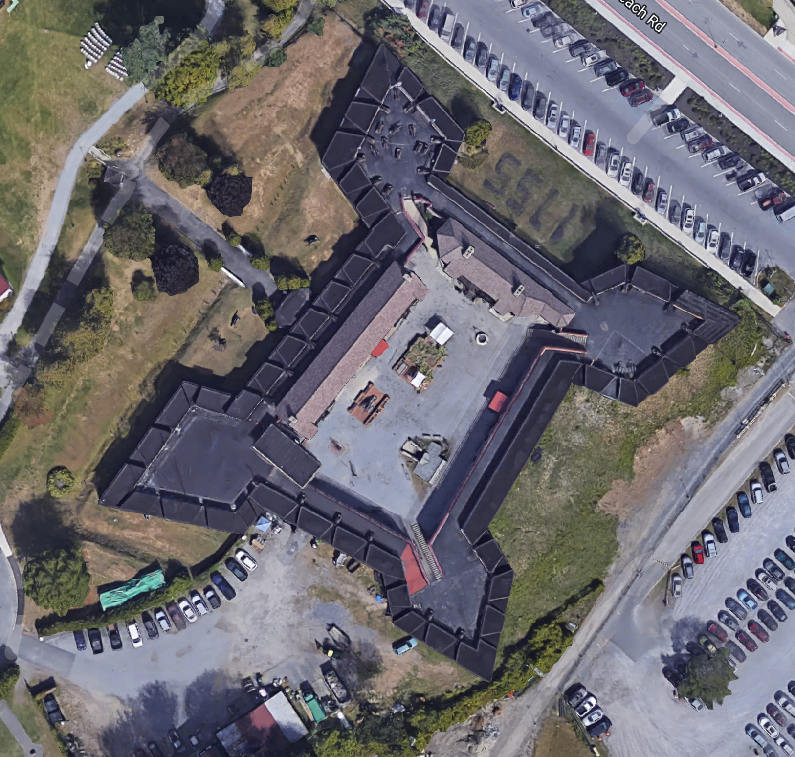
    Forts were built with enfilading in mind.  Bastions protruding at the corners opened up fields of fire by eliminating blind spots, making them very challenging to approach.  Bastions provided defenders with an opportunity to apply cross fire into attackers, creating an enfilade.  A quick look at the Google Earth images for Fort Niagara, Fort Stanwix and Fort William Henry (rebuilt on original footprint) show the shape of the forts.  Fort Niagara, pressed up against a point on Lake Ontario, didn’t have the complete star shape because it didn’t have the threat of armies rolling up on their flank, but you can see how the walls offered fields of fire consistent with enfilading attackers.

    So sappers – trench diggers – had to contend with steady musket and cannon fire raining down on them from many angles.  This had to be one of the worst jobs in the army, especially in soil with heavy rocks and roots, to be digging a trench while someone is trying to kill you from an elevated position.  But sapping worked, and throwing bodies at a problem has historically been appropriate behavior with European armies.  To give sappers a fighting chance of finishing the trench, they used mantlets and other protective structures to shield them from enemy fire.  Eventually the fort they were digging towards would run out of ammunition, or the besieged would grow exhausted from constant bombardment, and momentum would shift from the inside to the outside of the fort.  There’s another definition for sapping, and that’s gradually draining the strength and energy from someone, and that’s exactly what a siege would do to the inhabitants of the fort.  Watching the enemy get closer and closer must have been incredibly stressful, especially when you knew some of those enemy chose not to take prisoners.

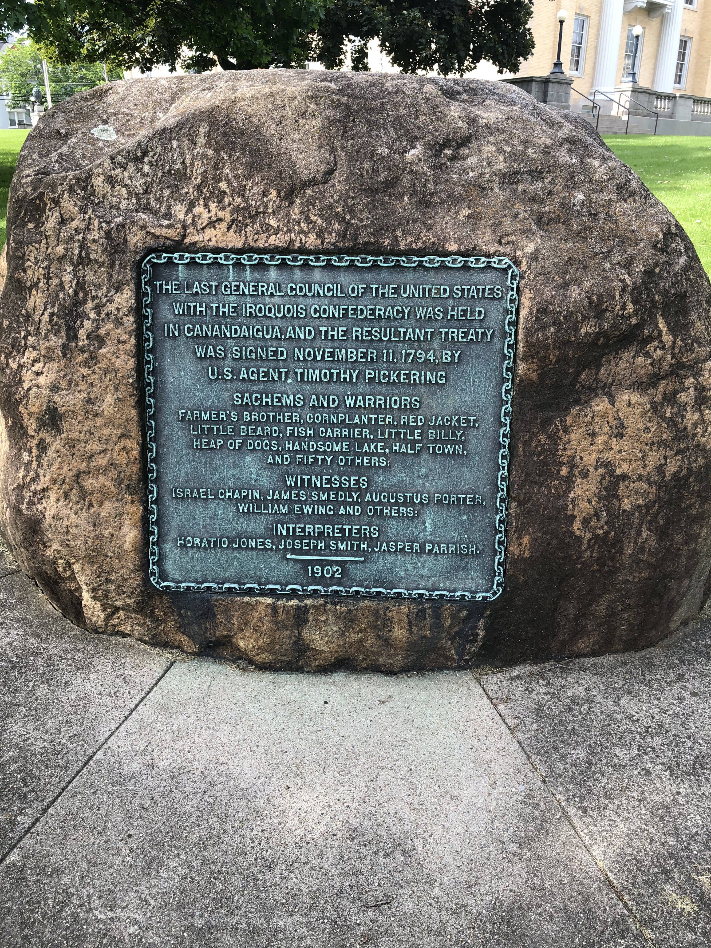
    Fort Duquesne, in what is now Pittsburgh, wasn’t the most robust fort to begin with, and quickly fell to the French siege to begin hostilities in the French and Indian War in North America.  At Fort William on Lake George, the British and American forces held until their cannon began to overheat and fail.  A failing cannon was a dangerous thing indeed, often exploding and killing the crew that was manning it.  During the Revolutionary War, Fort Stanwix famously held the siege off, but largely because the British, loyalists and Iroquois laying siege on them were scared off prematurely by Benedict Arnold’s deception (fed a rumor that he was much closer and with a much larger force than he actually had).  If it weren’t for Arnold’s ploy the fort may have fallen within a day or two.

    Sappers got the enemy to your walls, but cannon was the great equalizer.  Without cannon to pulverize walls and the people behind them, armies had to play a waiting game.  Basically starving the besieged out.  With enough stores the army might run out of time before they were able to get through.  The Shawnee tried this tactic on Boonesborough in Kentucky; burning crops and killing cattle to starve the settlers out.  When it didn’t work quickly enough they dug a tunnel towards the settlers walls to plant British gunpowder.  Heavy rains collapsed that tunnel killing many of the Shawnee and saving the settlers.  Tunneling, or mining, was different from sapping in that you’re completely underground and vulnerable to these types of collapses.  The most famous mining attack took place at the Battle of Messines in Belgium during World War One when upwards of 10,000 German soldiers were killed when a million pounds of explosives mined below the German lines were exploded.  Clearly, digging towards the enemy didn’t end with the Revolutionary War, and no war proved that like World War One.

    Having walked through a few forts in my time, I’m struck by the amount of work that went into their construction.  It must have been formidable and more than a little terrifying to be on the outside trying to fight your way in.  But being trapped on the inside surely wasn’t much better.  When you hear about the defenders of Fort Stanwix or Fort William Henry fighting to exhaustion, knowing the fate of many who surrendered to the Native American warriors in other battles, its clear there wasn’t much pleasure rendered on that side of the wall either.  Troops sent to relieve the besieged were often vulnerable to ambush, which is exactly what happened at La Belle-Famille during the siege on Fort Niagara and at Oriskany during the siege on Fort Stanwix.

    Sapping offered refuge from the designed killing fields that star shaped forts created.  It was a harsh, horrific, exhausting slog digging under fire from the perimeter to the fort walls.  The alternative was an exposed, high-casualty ground level attack.  Given the choice, I’d probably have grabbed a shovel myself.  Thankfully, I can just stroll the grounds and contemplate the violence that took place around these forts early on in our history.

  • Treaty of Canandaigua

    This week, on my drive from Buffalo to Seneca Falls, I made a quick detour to visit a rock.  I live in the Granite State, so I know a thing or two about rocks, but the rock I was visiting is unique because of a tablet mounted to it commemorating the Treaty of Canandaigua on November 11, 1794.  The location of the 1902 monument, on the lawn of the Ontario County Courthouse, is roughly where the treaty was negotiated between representatives of the United States, the Iroquois Confederacy and Quaker moderators trusted by the Iroquois.

    After the Revolutionary War, American sentiment towards the Iroquois Confederacy was at a low point. The Iroquois were significantly weakened after the war, and the Americans were operating from a position of strength when they signed the Treaty of Fort Stanwix in 1784. The location is notable, as it was five miles from the site of the Orinasky ambush that wiped out many of the men from this county. Western Iroquois tribes with loyalists participated in that ambush, and seven years later a treaty was being negotiated at the fort those ambush victims were marching to relieve. The treaty ceded massive tracts of land from New York, Pennsylvania and Ohio to the Americans in an agreement known as “the Last Purchase”. The Six Nations refused to ratify the treaty but the damage was done.

    Fast forward ten years and growing tensions between the United States and Native American tribes on the western border threatened to blow up into war. Suddenly the Iroquois Confederacy seemed a significant threat should they side with western tribes and declare war on the United States. President George Washington sent Colonel Timothy Pickering, a Bunker Hill veteran from Salem, Massachusetts, to negotiate a new treaty with the Iroquois.  The location for the meeting to negotiate the treaty was chosen by another Massachusetts man, Israel Chapin.  When Chapin died a few years after the treaty was ratified, Red Jacket, once an enemy of Chapin’s during the war, gave a eulogy at his gravesite.  I wrote briefly about Red Jacket practicing his speech for Canandaigua at the spectacular She-Qua-Ga Falls previously.  There’s a deeper dive that needs to take place into the lives of these three men in particular, but also the incredible list of names on the tablet.  I can’t wait to learn more about Heap of Dogs.

    The treaty is called both the Pickering Treaty and the Treaty of Canandaigua and is still in use today.  Every year on November 11th there is a ceremony and celebration at the monument to lasting legacy of the treaty.  It undid some of the damage from the Treaty of Stanwix, and reserved land for the Iroquois that is still protected.  The land rush that took place after the Revolutionary War was like a tidal wave sweeping over New York westward.  That they were able to set aside significant tracts of land for those who called it home before Europeans settled here remains a notable achievement.

  • Oriskany

    I wasn’t planning on another detour on this trip, but saw the sign, calculated the total time the detour would take and made the decision to stop by the battlefield.  I was deeply impressed with the quiet dignity of the site, and reflected on the violence that took place in the ravine I walked down into.  The battlefield is nothing but tranquil today, save for the landscaper mowing the fields.  But at 10 AM on August 6, 1777 this valley erupted in thunderous clouds of gunfire and screams the hidden Loyalists and Iroquois aligned with the British ambushed a column of American patriots and Oneida Indians allied with them.  That this battle pitted neighbor against neighbor, Iroquois tribe against Iroquois tribe makes the results all the more devastating.

    We met the enemy at the place near a small creek. They had 3 cannons and we none. We had tomahawks and a few guns, but agreed to fight with tomahawks and scalping knives. During the fight, we waited for them to fire their guns and then we attacked them. It felt like no more than killing a Beast. We killed most of the men in the American’s army. Only a few escaped from us. We fought so close against one another that we could kill or another with a musket bayonet…. It was here that I saw the most dead bodies than I have ever seen. The blood shed made a stream running down on the sloping ground.” – Blacksnake, Seneca War Chief

    When I decided to divert from I-90 to check out the battlefield, I had no idea what to expect.  I’d seen pictures of the monument, but there’s an emotional weight in walking in the footsteps of those who perished here down into that ravine, across the creek and up the other side.  The land looks remarkably similar to what it looked like then.  Perhaps more fields have replaced the deep forest of the day, but this area remains largely undeveloped, and will remain so as the Oriskany Battlefield State Historic Site.

    So I pulled into the driveway leading to the monument and drove down to the parking area.  The 85 foot tall oblisk built in 1883 dominates the landscape in front of you.  But I’d noticed another monument and some signs marking historically relevant locations on the battlefield off to the right as I drove in, and decided to walk over to check those out first.  This is the best approximation of where the ambush took place, and looking around it seemed as appropriate a spot as any.  I walked up to the monument honoring General Nicholas Herkimer, wounded in the initial ambush, who famously directed patriot forces into defensive positions from behind an ash tree at or near this location. The Iroquois warriors would wait for a soldier to fire their one shot then rush at them with tomahawks and knives. This was up close, brutal fighting that decimated the American forces. Herkimer directed his men to pair up, with one firing while the other reloaded, to counter this rush.  Herkimer was shot in the leg, and died when the amputation to save him didn’t go as planned.  I wonder sometimes if Benedict Arnold, shot in the leg later in the same year, refused to have his leg amputated after seeing what happened to Herkimer?

    Of the almost 800 American and Oneida ambushes, almost half were killed, and overall casualties were over 500. For the patriotic farmers who rallied to save their brothers-in-arms under siege at Fort Stanwix, the ambush quickly ended their dreams and destroyed the lives of their families back home.  By all accounts these were tough losses for any army, but for Tryon County, it was a devastating loss of fathers, brothers and sons that brought the county to its knees.

    Ultimately the relief column suffered far more casualties than the defenders at Fort Stanwix, who were saved when Benedict Arnold orchestrated a con to make the British and Iroquois think he was much closer to engaging with them, and with many more troops than he actually had.  But that’s a story for another day.  The Loyalists who survived would eventually flee to Canada or other British territories as reprisals reached their homes as momentum swung away from the British.  While the battle at Oriskany was a huge setback in momentum, it was another domino in the string of events that led to the defeat of General Burgoyne’s army at Saratoga.

    On this rainy June afternoon, I had the place largely to myself.  There were about a dozen New York State Troopers visiting, a couple huddled under an umbrella, a man walking two Labrador retrievers, and… me.  The experience reminded me of my trip to Hubbardton a couple of months ago, the quiet solitude and signs describing the lay of the land on the day of the battle were similar.  But Oriskany felt different, because what happened here was different. Hubbardton was a retreating rear guard being caught by a faster moving British force. Oriskany was neighbors ambushing neighbors. Iroquois tribe against Iroquois tribe. A mass casualty event that shook a region. The Revolutionary War was far more complicated than Americans overthrowing a tyrannical oppressor. It was a messy divorce that forced each individual to decide which parent they were going to remain with, and which one they would betray in the most violent ways.

    Visiting the Oriskany battle site is easy. Roughly ten minutes off I-90, it offers a quick respite from travel, and perspective on the sacrifices others made to give us the freedom to do so. On the day I visited, as with other battlefields related to the Saratoga campaign, a quiet stillness prevailed. There’s a small building set down behind the monument where you can learn more about the site and events that day, and (please) leave a donation to help support the maintenance of this sacred ground.  The obelisk is showing signs of wear and needs renovation, but remains a striking tribute to those who fell here.