Tag: Spicket River

  • Arlington Mill Reservoir

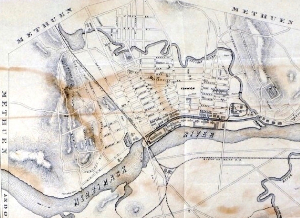
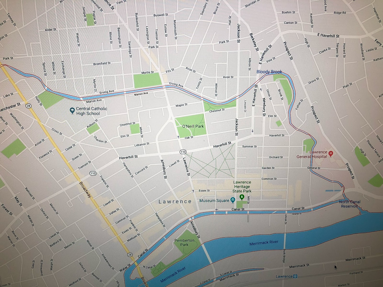
    There are two ponds that flow into the Spicket River that helped supply the Arlington Mills in Lawrence with its water.  Each pond has a unique history worthy of a closer look.  Arlington Mill Reservoir, or today just Arlington Pond, and Big Island Pond, which borders Derry, Atkinson and Hampstead, New Hampshire.  Big Island Pond flows into Arlington Pond, which then flows into the Spicket River, which powers the Arlington Mills before eventually flowing into the Merrimack River and ultimately the Atlantic Ocean.

    Arlington Pond occupies 269 acres and is located in Salem, New Hampshire.  In 1919, 100 years ago this year, Arlington Mills purchased the land surrounding and underneath what is now the pond.  The next year they began construction of a 48 foot tall dam, which they called the Wheeler Dam, after the Wheeler Mill that once occupied the site.  In 1923 they completed the dam and filled the reservoir.  In doing so a stretch of Old North Salem Road and the foundations for the original mill buildings were submerged.  That would be an interesting dive site.

    People bought the land around the lake.  According to the Arlington Pond Protective Association, “The land surrounding the lake was owned by Thomas Kittredge, Sr. He owned a coffee shop in Haverhill, Massachusetts and sold parcels of the land to his customers; the lots were nicknamed “Coffee Pot Lots”.” – APPA

    I don’t see Arlington Pond often, but I hear it.  Boats, fireworks, snowmobiles and ATV’s are loud enough at night that the sound travels to where I live.  I’m roughly halfway between Arlington Pond and Big Island Pond.  And while Arlington Pond is much more accessible from a viewing standpoint, I’ve spent much more time on and in Big Island Pond.  Where Arlington has built up around the entire  shoreline, Big Island Pond has a more rural feel thanks to the protected land at Governor’s Island.  But Arlington has it’s charms too.  At some point I’d like to get on the pond and go for a swim there. Then again, you might say that I’ve already swum in the water before it gets there.

  • Bloody Brook

    There’s a tiny brook that flows from Searles Pond near Holy Family Hospital and feeds into the Spicket River just before it in turn feeds the Merrimack River in Lawrence.  It’s name betrays a violent history, long before Lawrence and Methuen become heavily developed urban environments.  Google has led me a couple of times to a very useful site that details the history of Methuen and some of the surrounding area that once was part of Methuen.  You can Magenweb here.

    The name Bloody Brook was said by George Frederick, late town treasurer and authority on Indian lore, to come from a terrific battle between the Agawams and the Tarrantines in the days before the English settlement. As near as white men could tell after they came, about September 1615 the Tarrantine Indians of Maine had a poor harvest so they invaded the Merrimack Valley to raid the fields,and naturally the local Indians resisted as best they could. It is said that clubs and stone axes, rather than arrows, were found in this area, indicating the closeness of combat. 

    The Tarrantines were part of the larger Mi’kmaq tribe of coastal Native Americans who lived from Maine to Newfoundland.  For them to make the long trip down to what is now Methuen to raid the fields of the Agawam speaks to their desperation.  There is another famous Bloody Brook that points towards the better-known history of conflict between the white settlers and Native American population.We hear a lot about the encroachment of European settlers in the area and the conflicts that arose with the Native American population as a result.  The conflict between tribes is a lesser known, but no less violent history of the land we live on today.  Names like this dot the map, just waiting for someone to remember the ghosts who once inhabited this land.


  • Straightening the Spicket

    Straightening the Spicket

    The Spicket River flows from New Hampshire into the Merrimack River in Lawrence, Massachusetts.  The river has changed over the years, particularly during the explosive development of Lawrence and Methuen in the Industrial Revolution.  By the late 1880’s the City of Lawrence had enough of the typhoid breeding ground that the river had become and decided to straighten the river.  Looking at the first map from the 1850’s followed by a Google map from 2018 you see just how much they changed the Spicket River in the Lawrence stretch.

    Unfortunately, they didn’t dig the channel deep enough and the river bed can’t handle the floodwater that were once absorbed by the natural flow of the meandering river that once flowed through the city.      Heavy rains combined with spring melt-off creates a flood plain that makes some areas of the city impassible.  Perhaps no place carries this burden more than Central Catholic High School, which sits right where the the flood plain once acted as a sponge for the river.  The city doesn’t seem to be in a hurry to correct the situation, so every few years there’s a lake where the CCHS parking lot once was.  The price of progress, or the price of poor engineering?