Tag: White Mountain National Forest

  • A Winter Hike on the Welch-Dickey Loop Trail

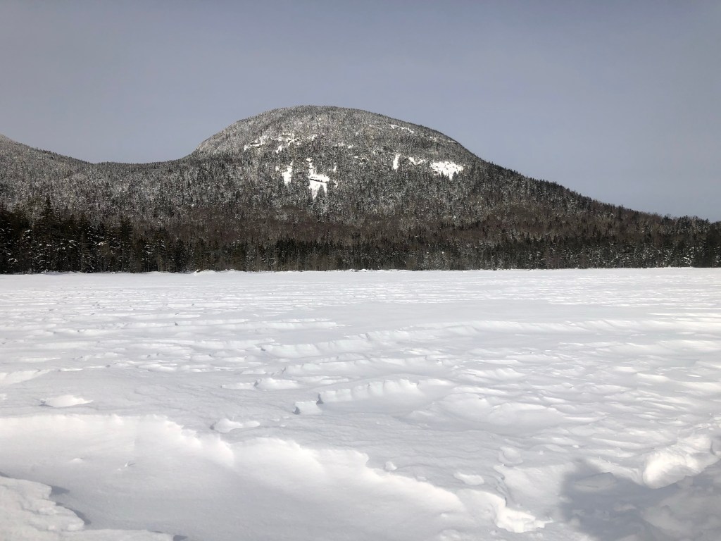
    The Welch-Dickey Loop Trail is one of the most popular trails in New Hampshire. There are many reasons for this, including its relative closeness compared to trails further north and its proximity to popular recreation destination Waterville Valley. But really, people hike this trail because the views are spectacular and you can do the hike in a few hours if you want to push, or linger with those views if you wish to take your time. In summer the blueberry bushes are generous and those ledges are great places to sit awhile. In winter, those ledges look like toboggan runs to a hard landing. Best to stick to the trail, wear spikes and respect the unforgiving nature of the White Mountains when people get careless.

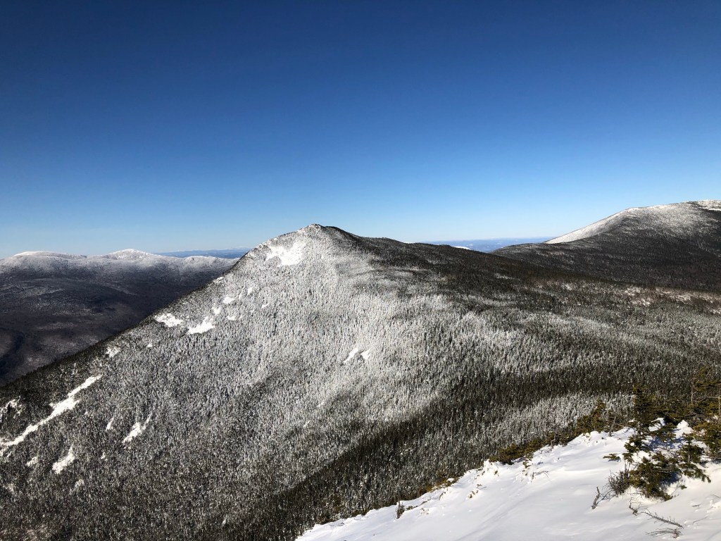
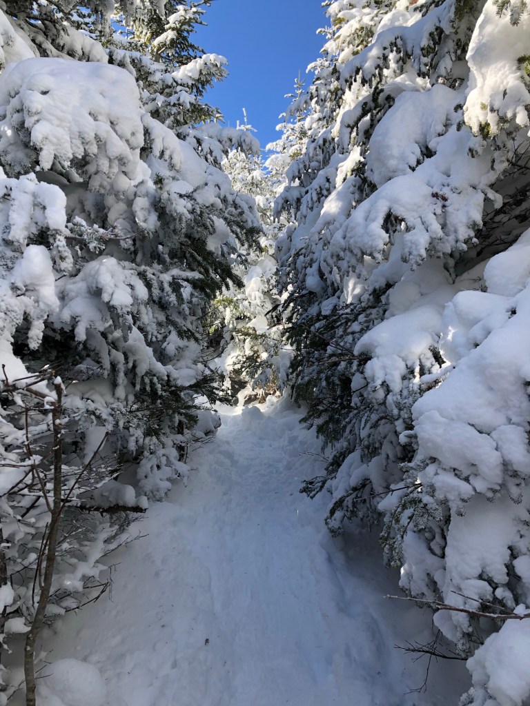
    As the name infers, there are two mountains on this 4.4 mile loop: Mount Welch and Mount Dickey. Both have a ton of exposed granite ledge that let the world open up for you, making the payoff in views exceptional for the effort expended. In summer, it’s a fun scramble up the granite, in winter, it’s strongly advisable to have micro spikes or crampons. Even with spikes on, I was very deliberate with every step hiking up Mount Welch. It’s not a trail to be doing in casual footwear in winter.

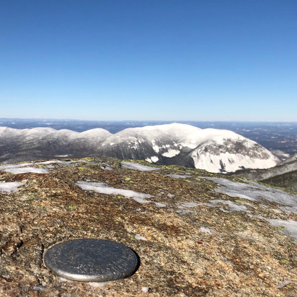
    At some point along the way, I recognized that the prominence of the summit wasn’t ever my goal, it was simply getting out in nature at elevation, to a place where I earn the view with every step. I’ve been too distracted by numbers (48, 200 & 4000: there are 48 4000 foot mountains with a prominence of 200 feet or more) lately, forgetting that lists are not the point. While it’s in my nature to finish what I started and complete the 48, it took this winter hike on the Welch-Dickey Loop Trail to remind me that deep down I’m seeking experience, not validation. The numbers can take a hike. I’ll finish when I finish.

    If you’re looking for incredible views with a relatively easy hike, the Welch-Dickey Loop Trail brings you to two summits of the five I’d recommend in New Hampshire, along with Mounts Monadnock, Major and Willard. In summer or during foliage season these hikes are maddeningly crowded on the weekends, but winter brings relative quiet and pristine beauty. Just remember those micro spikes.

    The steep ledge scramble up Mount Welch
    Would you hike this without spikes?
  • Finding the Magic Behind the Ice

    There’s something uniquely foreign about the experience, akin to visiting an ice palace in a fantasy movie. Humans aren’t supposed to be in such places. At least that’s what we tell ourselves when we look at a waterfall from the front. And when it’s frozen in winter? Well, there’s something chillingly locked away in… there.

    Now, in case you’re wondering, this isn’t the first time I’ve been behind a waterfall. Like countless thousands, I’ve walked behind Niagara Falls and for the price of admission seen the roaring waters dropping away from the safety of a dim, well-engineered if soulless tunnel. Interesting, to be sure. But not magical.

    It’s clearly the ice. It forms a wall over the falls that announces, “sorry, closed for the season”. There’s beauty in the frozen stillness of a waterfall in winter, of course, but there’s a small part of you that feels betrayed by the ice. You hear the muted sound of water falling deep inside, and want for more.

    Enter Beede Falls in Sandwich, New Hampshire. In warmer months it’s a 35 foot horsetail of falling water with a popular swimming hole. In winter it’s an ice bulge, beautiful but seemingly as inaccessible as other frozen waterfalls. But this one offers a secret for those who dare. You can duck and crawl in behind the falls on the left or right side, and even crawl all the way through if you wanted to. For some less tall than me standing up is even possible.

    I wondered at the characters over the years who have crawled behind the falls in all seasons. I wasn’t the first on this day, and other hikers waited patiently for me to finish to have their own turn in the tight tunnel between granite, water and ice. How many humans have made this crawl over the thousands of years that this cave and waterfall have danced together? A lot, I suppose. But for a few minutes, there was only me and the ice and water.

    That’s where I finally saw the magic locked away behind that frozen blue skin. Deep behind the water is indeed falling, forming icicles and frozen bubbles successively grown upon each other to form otherworldly sculptures. And through it all that shower of water penetrates the center, surrounded by its icy shield and backlit by the daylight beyond. An incredible wonderland so foreign to me, so delightful, that I felt I’d gone to another world. And indeed I had.

    Beede Falls, behind her icy shield
  • Twice the Fun: Mount Israel & Beede Falls

    Not every amazing hike is over 4000 feet. In New Hampshire there are other lists besides the 4K list, lists like 52 with a view, which offers some beautiful views with a bit less effort than the 4000 footers. For a warm Sunday with snow melting into snowball-making consistency, a couple of friends invited me to join them on a hike of Mount Israel and for a bonus, a visit to Beede Falls, one of the waterfalls on my personal checklist to see in 2021.

    A bit of history is in order. Mount Israel is named for a settler named Israel Gilman, who lived near the trailhead for this mountain. There’s still an active farm near that trailhead, and it’s easy to imagine the land in the 1760’s when Gilman was walking around this place. Mount Israel is located in Sandwich, New Hampshire, which also has a bit of history in its name. The town of Sandwich is named for the 4th Earl of Sandwich, John Montagu, supposedly the inventor of the sandwich. Given that, I made a point of packing a sandwich for the hike, in honor of the Earl (or whomever it was, lost to history, who made sandwiches for him).

    The hike began at Mead Base in Sandwich, with a straightforward two mile hike up the Wentworth Trail. For those wondering about the name of the trail, a bit more history for you: Sandwich was founded in 1767 from a grant by Governor Benning Wentworth. Another name you’ll come to know is Daniel Beede, who was chosen to lead the settlement of Sandwich and granted 100 acres. Place names usually betray the history of that place, and if you look hard enough you’ll find Easter eggs like these on maps and street signs.

    I quickly fell in love with the Wentworth Trail. It winds through old growth oak and pine trees, with some tree trunks four feet in diameter – exceedingly rare around here. The snow cover acted as a spotlight on the biggest trees in the forest. I was smitten with one oak tree that had to be a witness to the transition from Native American land to English settlement. Further up, the trail wound around granite ledge and hemlocks, offering glimpses out to Squam Lake and the surrounding ridge line.

    The summit of Mount Israel is 2620 feet with 1900 feet of elevation. Despite its modest height relative to some of the other mountains in New Hampshire, it didn’t disappoint in views or the stunning beauty of the trail itself. Steep enough for a workout, short enough to give you time for other adventures. We made short work of the trail and before we knew it we were back at the trailhead at Mead Base and Act II.

    A half mile from the trailhead is another wonder worth visiting, Beede Falls, which is named after our friend Daniel Beede. The walk itself is wonderful, with granite ledge and scattered glacial erratics lining the edge of the trail. A large cave named Cow Cave offered a quick distraction. It was so named by some cows that decided to shelter inside the cave one day deep in the past. The cave was interesting, to be sure, but the real show was Beede Falls.

    In late February the falls were largely frozen, and we walked out on the ice that must be a lovely swimming hole on a hot summer day. The amazing part of Beede Falls in looking at them from behind. The falls froze solid in front, but you can access the back from the left and right side, and crawling behind them offered a magical trip into an icy palace. Water cascaded from the granite ledge, plunging between the icy wall you see on the outside and the cave formed behind. There’s just enough room to go all the way through it if you’re adventurous and don’t mind getting a little wet.

    In all our days on this earth, how often can you say that you got to see the world from the summit of a small mountain and from the crawlspace behind a waterfall in the space of a couple of hours? If you’re blessed with good health and mobility, then surely life is to be lived fully. Adventures like this one are within reach of most of us. All you’ve got to do is get out there.

    Frozen Beede Falls
    Ice wall in cave behind the falls
    Summit of Mount Israel
  • Hiking Cannon Mountain

    A flurry of texts over the work week from two directions with questions about hiking led to a decision to join forces for a hike of Cannon Mountain. On the one hand were the Perry’s, increasingly famous in the White Mountains for years of summiting mountains and red-lining trails. I don’t recall a hike in the last couple of years where they didn’t know at least one person on the trails. And a text from my niece Kellyn offered a nice treat, with her deciding to hike with us as well.

    Cannon Mountain is an old granite mound that’s famous for a sheer rock face that once held the Old Man of the Mountain until it collapsed in 2003, and for the tram built to promote tourism and skiing on the mountain in 1938, making it the first passenger tramway in the United States. The Old Man of the Mountain gave this granite mound its first name, Profile Mountain, but eventually its resemblance to a cannon from some vantage points let to what we’re familiar with now.

    So the stage was set for four hikers to set out on a cold February 13th morning for a hike from Lafayette Campground. We chose the Lonesome Lake Trail, with three of us starting in micro spikes on the snow-packed trail. Our fourth hiker stuck with snowshoes the entire time. The conditions on the popular trail made either option fine. As with other hikes, you quickly know when it’s time to put on the snowshoes. For us that was when we took the largely unbroken Dodge Cutoff Trail over to Hi-Cannon for the hike up to the summit.

    Lonesome Lake is a beautiful lake sitting in the bowl of Cannon and the neighboring mountains of the Kinsman Range. It’s a destination of its own, and plenty of people hike up to see it, walk on the frozen lake for the beautiful views it offers, and then hike back down. But you don’t summit mountains when you turn around halfway. We powered on, snowshoeing through a wonder of marshmallow trees up the steep trail. There’s one ice-caked ladder on Hi-Cannon that I’ll always remember for the limited footing options presented to us, but we all got past it with a little help and a dose of courage.

    The thing about summits is they tend to be much colder when you’re exposed to the wind and you stop moving. Sweaty gloves quickly freeze up, making a change a requirement to keep your fingers working. We considered the observation tower for a few minutes and opted to just hike down to the ski resort’s Mountain Station, where I’m told you can buy a beer at 4080 feet. I opted for hot chili and hot chocolate, with extra hot, thank you. It’s a rare day when you can summit a mountain and have hot chili waiting for you. We quickly warmed up and reached a point where if we didn’t get going we might choose to close out the place. Onward.

    Crossing a ski trail is akin to crossing a highway. You judge the oncoming traffic, decide whether your speed can overcome the approaching traffic’s speed and go. We quickly crossed over to the trail back to the summit observation deck, crowned the summit and began our descent using the Kinsman Ridge Snow Chute, er, Trail. On the map, 4/10’s of a mile of hiking, but a lot of squiggly elevation lines stacked up in a small space. We butt-slid down large sections, my snowshoes were more telemarking skis on other sections, and we all collected snowy memories that will make great tall tales someday.

    On one of the butt-sliding sections I lost a water bottle. It wasn’t until we’d snowshoed across Lonesome Lake and I changed to micro spikes that I realized it. My disappointment at losing it turned to delight when we got to the trailhead and someone who’d found it and beaten us down the trail while we lingered at the lake had left it sitting on a post waiting for me. Good hiking karma right there. It was hard to come away with anything but positive vibes after hiking Cannon Mountain on a pristine winter day. A solar halo signaled goodwill to all. A very good day indeed.

    Cannon Mountain from Lonesome Lake
    Solar halo through the frosty trees
    Lonesome Lake with Franconia Ridge beyond
  • Hiking Mounts Liberty and Flume

    Let the record show that on the last day of January, 2021 this author fell in love with a pile of granite atop a ridge in New Hampshire. Mount Liberty rises 4,459 feet with a prominence of 379 feet, making it one of the state’s 4000 footers. I’ve flirted with Liberty for years, but when I wiped the slate clean and re-started my pursuit of the 48 4K’s last year in the middle of a pandemic I decided to leave this very popular hike for a quieter day. How about first light on the last day of January?

    Mount Liberty was named for George Washington, but since there was already a Mount Washington Liberty seemed appropriate. It seems when you look at the mountain from a certain angle it looks like George lying in state. And sure enough, from a certain angle you can see that.

    While Liberty was the goal all along, the proximity of Mount Flume, itself a 4000 footer with the rather intriguing measurements of 4,327’/407′ prominence made it a no-brainer for a peak bagging day. Since we were hiking an out-and-back, we ended up summiting Liberty twice, making for a three summit, eleven mile hike. There’s a loop option that includes the Flume Slide Trail, but we just weren’t that ambitious (and a friend talked me out of it). Talking to a hiker with crampons who’d done it, he described it as “gnarly”. And not in a good gnarly way. Better to stick with the safer route, thank you. Mount Flume is the source of Flume Brook, which carved the spectacular gorge named, you guessed it, The Flume. It’s worth a visit on a quiet day in late spring, but best done mid-week and early to beat the crowds.

    You know right away that most people turn around after some time on Mount Liberty by the condition of the trail. The Liberty Springs Trail was compacted snow the entire hike, and the summit was completely compacted. The trail between Liberty and Flume was defined but definitely not as well-travelled. Since we started early, we were contributing to the trail break, but it was just compacted enough to keep the snowshoes strapped to the pack (more on snowshoes in tomorrow’s post).

    For this hike, I’d texted a college friend I’ve hiked with before. The two of us met at the Liberty Springs trailhead at 6:45, making us some of the first hikers to climb that morning. We saw a few people on the summit of Liberty and were soon joined by a few more. The crowd was even thinner on the summit of Flume, with just a few diehards when we arrived there. But the day was spectacular and the traffic was picking up. Our return hike to Liberty required a lot of passing maneuvers, which generally meant whoever was coming downhill to posthole into virgin snow off trail to allow someone to pass. In summer you don’t think anything of it. In deep snow you think about it every time.

    Back on a now-crowded Liberty, we had a quick snack, drank some water and began our two-hour descent. Plenty of people passed us on this leg, suggesting the return hike can be much faster for those who like to jog or butt slide down the trail. We took our time, a concession of age or wisdom or experience. I’m just not going to jog down a mountain with a full pack with snowshoes strapped on the outside. With all the traffic and the sun warming the snow the trail was breaking down a bit. Our timing was just right.

    Mount Liberty, seen from Mount Flume summit
    Trail between the summits was a winter wonderland
    USGS marker on Mount Liberty with Cannon Mountain in the background
  • The Art of Packing for a Winter Hike

    Contingencies. I pack for contingencies. Most of it stays in the bag, bulging against the sides, weighing the pack down directly onto the hip belt, as designed, and a bit on the shoulders, as is the way. First aid kit, extra warm clothing, extra food, and, it turns out, just enough water for this eleven mile trip. Snow demands micro spikes, but also snowshoes. Mine spent most of the day strapped to my backpack, but I gave them a try for about an hour of hiking before strapping them back on the pack. The compressed snow and narrow trail made wearing them more hassle than salvation. Sometimes you try out your contingencies and realize that you were better off with the original plan. But I do love those heal lifts on steep inclines.

    It was -4 degrees Fahrenheit at the start of my hike this morning. Most layers packed as contingencies went right on the body for the start of the hike. Snow has a way of being crispy and slippery when you dip below zero. And the trail we started hiking wasn’t the same trail we descended when the sun rose and warmed temperatures into the twenties. Having the right footwear and accessories is essential when you see swings in temperatures like that.

    Still, for all the contingencies planned for, most everything stayed in the pack. Sleeping pad, extra layers, way too much food, all of it mocking me on the steepest parts of the incline and for most of the descent. But as soon as you don’t pack it you know what’s going to happen. Yeah, contingencies, especially in winter, must be a part of your kit. You’ve got to have a winter pack that can handle all the extra stuff, provide tie downs for the snowshoes, and remain an afterthought for the duration of the hike. For day hikes I’ve settled on an ULA Photon pack, which offers everything I need and the space for those extras.

    Winter hiking in New Hampshire offers plenty of beautiful moments. Moments that serve as exclamation points on the trip and in your life. But winter can offer up stunning beauty and calamity quite rapidly in the White Mountains. Mother Nature doesn’t care about your feelings. You must be prepared for whatever she throws at you. And that’s what contingency packing is for. Sure it mocks you when it never gets used, but it also assures you that it will be there for you if you need it.

    The next blog post will cover the actual hike. Memorable, incredibly clear, and two more 4000 footers checked off. Stay tuned, there’s a lot to cover.

  • Hiking Mount Jackson (New Hampshire)

    Too many weekends since I last hiked to a summit. Basically, I skipped December for the holidays, and was feeling the built-up restlessness that comes with knowing you’ve got things to do. I’d planned for Hale, but latched on to other’s plans for Mount Jackson for the views and banter of friends.

    Mount Jackson is a popular trail. We started early, meeting friends at the trailhead, but not early enough and parked along the side of Route 302. The out and back trail is roughly five miles of moderate hiking, with a short scramble towards the summit. Micro spikes were a requirement with a healthy dose of exposed ice and a couple of (frozen) stream crossings along the way.

    The straight path up Mount Jackson is via the Webster-Jackson Trail. That’s the trail we took, and judging from the compacted snow on the trail, so do most people. The day started overcast at the trailhead, but it was one of those hikes where you walk into sunshine, and like a jet bursting through the clouds, we emerged from the tree line to find bright sunshine and undercast in the valley below. Incredible views of Mount Washington and the Presidential Range greeted us, along with a few hungry Gray Jays looking for handouts.

    Mount Jackson is named for a geologist named Charles Thomas Jackson who completed a geological survey of New Hampshire in 1844. According to Wikipedia, Jackson seems to have been a somewhat controversial figure in his time, with a pattern of taking credit for discoveries others made. His brother-in-law was Ralph Waldo Emerson. For those who can’t get enough information on Charles Thomas Jackson there’s a wealth of information on Jackson in an article published by The State of Maine and while doing a bit of research I saw that the Bangor Daily News just published a small bit about Mount Jackson a few days ago. Apparently I’m not the only one wondering about why they’d name the mountain after this particular character, but based on his controversies he probably just named it after himself and nobody challenged it.

    After a lunch on the summit we started our descent, with plenty of butt sliding mixed into the walk back. A couple of side trails made for interesting views, we spent a few minutes at Bugle Cliff, but opted out of Elephant Head. After the stunning views on the summit maybe we were a bit spoiled.

    On the descent a couple of us hiked down to the Silver Cascade, which is very popular near Route 302 but involves some sweat equity further upstream. The small falls we saw were worth the side trip, with blue ice putting on a dazzling display for the two of us that sought it out. Waterfalls change by the day, and even though most of our party had seen them before I was still surprised more people don’t make the trek down. I’ll never turn down a side trip to a waterfall with kindred spirits.

    I’d circled this weekend in hopes of trying out my new Tubbs snowshoes. They’re a huge upgrade over the snowshoes I used to have, but we just haven’t had the snow accumulation to give them a workout. With the compacted trails today wasn’t the right day for them either. But that didn’t make the day disappointing. It turned out to be a spectacular way to spend a beautiful and cold Sunday; time with the closest of friends, relatively easy hiking and another summit checked off on the 48 New Hampshire 4000 footer list.

    View of Mount Washington
    Gray Jay looking for handouts
    Micro Spikes required
  • Past Peak

    Normally this weekend in New Hampshire is peak foliage season. But a sustained drought has stressed the trees just enough to pull peak ahead by two weeks. So the thousands of people plugging up the roadways of the Mount Washington National Forest were seeing the forest muted in dynamic impact. And yet they came. And they saw enough. For the mountains offer their own ruggedly stunning backdrop. I considered the tourists on my afternoon commute home from a day of hiking. Clusters taking a photo next to the roadside sign announcing you were in the MWNF, picture-taking all around you. Cars parked in odd assortments along the sides of the road, as if clung together by magnets the way the metal dust would clump together in the old Wooly Willy toy would clump into beards and eyebrows with a magnetic stick. Funny what you think about when you observe tourists in the wild.

    To be amongst the mountains is relatively easy when you live in New Hampshire. Less so, I suppose, if one were to live in Florida. But they have that tropical water hugging them on three sides, and I suppose the amusement parks and fresh oranges to consider too. But you can’t swim in a pond in Florida without risk of being dragged down by an alligator. There are no alligators in the mountains of New Hampshire. Maybe the occasional bear or mountain lion, but they mostly want the food in your pack, not you as food. The bigger threat to your well-being are the damned rocks. New Hampshire is the granite state, and as if to hammer that point home every trail is worn down to ankle-bending, knee-twisting rock. And in October those land mines are covered over in a bed of beautiful leaves. So a descent becomes a shuffle of sorts, as you work to avoid catastrophic injury on remote yet well-traveled trails.

    I have a friend who points out my tendency to pick overindulgent goals for myself. Really though; all my friends point this out. Like rowing a million meters on an erg in three months, or taking my family on a hike up the toughest mile of the Appalachian Trail, or peak-bagging three out-and-back peaks in one day, as I did yesterday with Mounts Willey, Field and Tom. I might have taken a hint from my hiking pro friend who refers to these three as the WTF hike. I chose to experience it on my own, with an extra helping of previous injuries I was nursing. WTF indeed.

    The morning after a hike like the WTF hike, the first step is to get out of bed without incident. Plant your feet and gradually put weight on the ankles and knees that you abused so ruthlessly the day before. Assess how much they resent you, and then shuffle to the bathroom for relief and some Motrin. This isn’t a walk of shame as much as a recognition of all you’d done, in the form of some tender moving parts and sore muscles. And I wonder in those moments of truth, am I past peak myself? Or simply overindulgent? I’d like to think the latter. All I can do is keep moving. Perhaps with a bit of moderation next time. I suppose that’s a perfectly reasonable request.

    Past Peak
  • Hiking Mount Willey, Mount Field and Mount Tom (and Back)

    I didn’t think this one through enough. An out and back using the same trail to hike three 4000 footers necessarily means you’re actually hiking five 4000 footers in a day. Ambitious. A bit reckless. A bit exhausting.

    10 miles round trip, with 4400 feet of elevation gain seems easy on paper. In practice the rock scrambles and ladders bridging impossibly steep sections made it a test of willpower. Some of those rock scrambles were borderline ladder territory as well. As wake-up calls go climbing the Willey Range Trail served as a good one. My heart was racing and my layers were shedding in no time. My mood bounced between exhilaration, despair and frustration with myself for not planning this hike a little better. But it was a quickly drafted plan B, and in hindsight, a good hike. Even if I wasn’t mentally ready for it.

    Mount Willey is 4255 feet tall and named after Samuel Willey and his family, who were killed in a landslide in 1926. Mount Field is 4327 feet and named after Darby Field, who made the first known ascent of Mount Washington in 1642. Mount Tom is 4052 feet tall and named after Thomas Crawford of Crawford Notch fame. The three peaks are relatively tame, other than the hike up the Willey Range Trail to the summit of Mount Willey. Approaching from the south, Willey is a tough ascent. It also makes a challenging descent. Starting and ending my hike with this trail set me up for a tough day. But I finished relatively healthy. And healthy with three more 4K’s checked off is enough for me.

    If you go, consider an approach from Crawford Notch or Mount Hale. The people who I ran into didn’t seem to have the same endurance test of ascending the Willey Range trail. For views, Willey and Field have some good observation spots, Tom not so much. But views are only part of the story. Finishing this hike and summiting these three 4000 footers was its own reward.

  • Hiking Mount Moriah

    The goal of life is to make your heartbeat match the beat of the universe, to match your nature with Nature.” – Joseph Campbell

    The last 4000 foot peak on the Appalachian Trail in New Hampshire before entering Maine is 4049 foot Mount Moriah. Hiking it as a single day out and back, it became a 9 mile round trip that felt just a little bit longer because the ankle objected to the angle of descent, which in warmer months means walking down exposed granite slabs with feet flat, toes down and weight distributed as evenly as possible, but slightly back on the heels. With good footwear this serves to spread the load across the sole of the boot or trail running shoe (for those who choose to endure a higher level of pain). This creates enough friction to keep you upright and in a controlled descent. But it also beats the crap out of your knees and ankles.

    But all that complaining doesn’t change the fact that I sat above treeline eating lunch with the White Mountains clearly visible all around me, and feeding Gray Jays who are well-known opportunists on this particular summit. I didn’t mind offering up a bit of my trail mix for the jays – there’s a certain thrill in interacting with wild animals, and a few almonds, peanuts and raisons were a small price to pay. And my heartbeat matched the universe a bit more today than it might have had I stayed home doing yard work. Aches and pains fade over time, but summiting Moriah remains a forever check mark and a step closer to matching my nature to Nature.

    The first half of the hike from the trailhead is very easy, with a gradual incline and minimal erosion compared to what you see in other parts of the White Mountains. Unfortunately the loggers have been busy on the lower hills, clearing much of the forest away. This is what happens when the land isn’t preserved, it becomes a “land of many uses”, including logging everything except a strip of land on either side of the trail. The logging served to preview the views that we’d see later, though it was marred by the clearing.

    The first wow moments come on the granite ledges of Mount Surprise, a 2194 foot gem that lives up to its name. Views of the Presidential Range were glorious, and served as a nice appetizer for the views we’d see later from the summit of Mount Moriah. They say on a clear day you can see forever from the summit, and it seemed we could. If there’s a drawback to the summit its the very small footprint that many people want to enjoy, and in a time of social distancing I was disappointed in the unmasked proximity of several people from a group of twenty-somethings. But lingering on the summit meant you were going to have that kind of company, so we made a point of wrapping up lunch and clearing the way for others.

    Mount Moriah is not a hike to do on a wet day, which is why I hiked it today instead of last week. But its a worthwhile hike to complete on a beautiful day. I look forward to doing it sometime when it has a heavy snow blanket to cushion the unforgiving granite. I’ll be sore tomorrow in the usual places, but it’s the price you pay for dancing in the clouds. Another 4000 footer checked off the list and a few memories worth celebrating.