Three Works of Daniel Chester French
While a lot of the attention in Concord, Massachusetts rightfully goes to the extraordinary writers who lived amongst each other in town, there were other highly-accomplished artists who lived there too. One of the most celebrated is Daniel Chester French. French was an American Renaissance/Beaux-arts artist most famous for his sculptures of The Minute Man at the site of the Battle of Concord and for the Lincoln Memorial. These two works bookended his career and ensured his place amongst the giants of Concord. In between, French had many notable works, but perhaps his most powerful, and one of his favorites, stands close to French even to this day.
With the centennial anniversary of the battles of Lexington and Concord approaching, key people in Concord were organizing an event for April 19, 1875. The existing obelisk marking the site had been placed on the eastern bank of the Concord River, where the British had assembled. The western side of the bridge where the minute men had assembled to fight them was bare ground. So a statue honoring those who fought the British was commissioned and designs were solicited for consideration. French, who’s father was a prominent judge and the inventor of the French drain, was friendly with Concord royalty, including Ralph Waldo Emerson. Emerson asked Daniel Chester French to submit a design, which of course was chosen. French was 22 when he started designing the statue, and 25 when it was unveiled to the world.


The ceremony to unveil “The Minute Man” as part of the centennial celebration of the shot heard round the world was attended by President US Grant, Vice President Henry Wilson, Poets Henry Wadsworth Longfellow and James Russell Lowell, Oliver Wendell Holmes and of course Emerson. They were joined by an overflowing crowd of over 50,000. Concord must have been a mad house that week in April 1875. Ironically, the man of the hour, Daniel Chester French, was not at the centennial celebration, he was in Florence studying under another famous sculptor, Thomas Ball, who created the statue of George Washington on his horse that forever rides in the Boston Public Garden. Much more information about French’s work on “The Minute Man” can be found in an extraordinary blog post here.
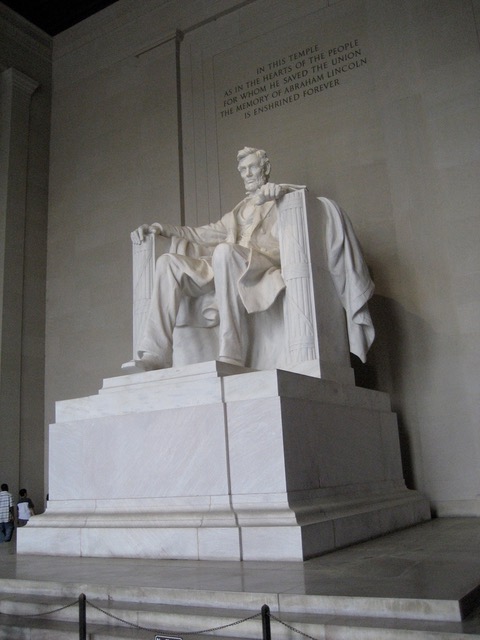
If “The Minute Man” marked the beginning of French’s career as a renowned sculptor, “Abraham Lincoln” in the Lincoln Memorial was French at his peak. When completed he was 70. “Abraham Lincoln” is 170 tons of white Georgia marble. French began the project in 1914 and did most of the work on this giant at Chesterwood, his summer home and studio in Western Massachusetts. French spent a lot of time on the hands of Abraham Lincoln. They’re very detailed and, it’s rumored, give a nod to Lincoln’s support for the deaf by subtly signing the initials “A” and “L”. I’ve visited the Lincoln Memorial three times and each time I pick up something new. I’ve never focused on Abraham Lincoln’s hands, but surely will should I have the opportunity to visit again.

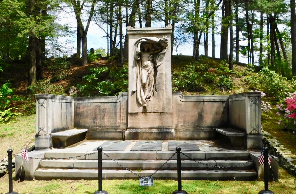
French died in 1931 and is buried at Sleepy Hollow Cemetery not far from Author’s Ridge. I’m sure he chose this spot carefully as his final resting place. With old family friend Emerson at the top of the ridge in front of his grave, and one of his favorite monuments right around the corner behind him; his creation “Mourning Victory”. The Melvin Memorial features French’s monument “Mourning Victory”. It was commissioned by James Melvin to honor the lives of his three brothers who died in the Civil War. “Mourning Victory” looks towards the South. “Mourning Victory” was unveiled on June 19, 1909, 45 years to the day after John was killed. Of the three brothers who died in the war he’s the only one buried at Sleepy Hollow Cemetery.
As we approach Memorial Day I think more about this monument and the devastation that came with victory it created for so many families like the Melvin’s.
“In memory of three brothers born in Concord who as private soldiers gave their lives in the war to save the country this memorial is placed here by their surviving brother, himself a private soldier in the same war.
I with uncovered head
Salute the sacred dead
Who went and who return not.”
On the day that I visited Sleepy Hollow Cemetery, there was a ceremony happening nearby. A solitary bagpiper played, filling the cemetery with music. I viewed it as a welcome from the permanent residents, and I tried to honor them during my time with them. Daniel Chester French, once a young man starting his career with “The Minute Man” statue just down the street from this spot, chose this place to be his permanent home. His own grave is simple, not displaying any of the Beaux-art charisma that you see in his work. Perhaps he drew inspiration from the simple dignity of his neighbor’s graves. I would contend that that quiet dignity is present in all his great works, and inspires us to this day.