Category: Travel

  • The Pine Tree Riot

    Maine is known as the “Pine Tree State” for good reason; it’s one of the state’s most significant natural resources. New Hampshire has plenty of this particular resource as well, but “Granite State” works just as well. That combination of pine sap and granite makes for a gritty edge. New Hampshire settlers were no pushovers, as seen in people like John Stark and Robert Rogers (born in Methuen, but raised in NH). You can add Ebenezer Mudgett to that list.

    White pine trees made excellent ship masts, and the British Navy needed a lot of them. New Hampshire was a British colony, and in 1722 the New Hampshire General Court passed the Pine Tree Law, reserving the best of these white pines – those with a diameter greater than 12 inches, as the property of the King of England. The trees were marked with a distinctive broad arrow slash. For 50 years New Hampshire lived with this law simmering resentment. These same trees could be sold to merchant ships for a nice profit, or made into floor boards or other profitable products for the lumbermen and sawmills in the state.

    When British surveyors tried to enforce a fine on a sawmill in South Weare, the owner of that sawmill, Ebenezer Mudgett and 40-50 locals rose up in defiance on April 14, 1772. Defiance to them meant hauling the Sheriff and his Deputy out of bed in the middle of the night and beating them with sticks, cutting the ears off of their horses (WTF?) and sending them fleeing off into the night. Not exactly Saratoga but hey we had to start somewhere, right?

    Eventually eight men were charged in the assault, but received light fines. One of the judges in the Pine Tree Riot case was my old friend Theodore Atkinson (I think he’s reminding me that I ought to pay a bit more attention to his accomplishments soon). The case got a lot of attention in the colonies as many others felt the frustration of the Pine Tree Rioters.

    Some say the Pine Tree Riot and the relatively light fines inspired those who participated in the Boston Tea Party in December 1773. What is definitely true is the White Pine became a symbol for New Hampshire in the Revolutionary War, and flew at Bunker Hill when John Stark’s New Hampshire Regiment held off the British flanking maneuvers.

    Today you can have a pint of beer at Able Ebenezer’s Brewing Company in Merrimack, New Hampshire and scan the walls to read some of this history. Maybe have a pint of Broad Arrow as you look at the replica Pine Tree Flag on the wall. Either way, celebrate that New Hampshire independent streak and the role our forefathers played in the creation of these United States.

  • Rhumb Lines and the Great Circle

    Whenever I take a flight of any consequence, I inevitably pull out the airline’s magazine to flip through.  I usually end up scanning the flight maps that appear in the last few pages of the magazine to see the arcs of the travel routes from various hubs.  I’m not a navigator, and I’m definitely not a mathemetician, but I have a keen interest in travel and the most efficient way to get from point A to point B.  Rhumb lines illustrates how that happens on a big blue ball, where we can’t very well cut through the middle.  Instead, we calculate the great-circle distance, which is the shortest distance between two points on the surface of a sphere, as measured along the surface of the sphere.  That dotted line that connects the two?  That’s our friend the rhumb line.

    On land rhumb lines don’t help much.  You’ve got to follow the lay of the land, accounting for natural obstacles to progress like mountains, large bodies of water or the George Washington Bridge.  Up in the air, or on the ocean where these types of obstacles are mostly eliminated (reefs and large continents excepted), plotting a course from say, London, latitude 51° :30 m:0 s N, longitude 0° :10 m:0 s W to Philadelphia, latitude 39° :56 m:58 s N, longitude 75° :9 m:21 s W is visually portrayed as a sweeping arc, as you’re flying from the smaller circumference northern latitude to the larger circumference southern latitude.

    Screen Shot 2019-05-19 at 8.04.49 AM

    There’s a nice online resource for visualizing this, as seen in the image above.  It comes from gpsvisualizer.com and allows you to enter either the longitude and latitude for your two points or simply plug in the airport codes for each as I did for London and Philadelphia.  This site didn’t help those Portuquese sailors trying to show other sailors how to sail to the Gulf of St Lawrence for cod fishing, so navigation maps were drawn and copied with the rhumb lines to show sailors which heading would get them there and back.

    I’ve made a few dotted lines across the world over the years, and hope to make many more.  I think basic navigation should be a requirement for all kids in school, as it teaches not just math skills but also illustrates how small we are blipping across the fragile surface of the earth.  Rhumb lines convey hope for the journey ahead, appreciation for how far we’ve come, and focus on the path we’re currently traveling on this great circle.  I’m surely not the only one to pluck that analogy out of this fundamental of navigation, but I’ll celebrate having gotten here eventually.

  • Frogs and All

    Yesterday, after thirteen lucky years together, our black lab Bodhi took his last breath.  Forgive me for this brief eulogy.

    There was the time you dug up every tulip bulb I’d just planted because you smelled the bone meal I used to fertilize them.

    There was the winter when we thought you escaped and were lost and drove around the neighborhood and then the town trying to find you late into the night, only to realize that you were lying under the shed all along.

    There were the countless questionable dining choices you made over the years on underwear, the extra ingredients in the cat litter, various leather goods and your favorite, flattened frog roadkill. The ongoing battle with the cats where they’d eat your food so you’d eat theirs. I respected that.

    I’ll miss those 10 PM power walks we’d do, and admit I don’t walk as much as I did when you were healthy. Back when you were a teenager you’d occasionally charge towards the woods, chasing a rabbit or a black bear or maybe a zombie; I was never really sure. I learned to anticipate those abrupt maneuvers and would spool out retractable leash like I was running out line on a marlin.

    Your best move was late night hide and seek. Pretty clever of you, being a black lab on a moonless night standing perfectly still when we let you out, until we gave up and went in for a flashlight. Even then you were usually found in the very last place I’d look for you.

    The pool filter won’t be the same without a full season of black fur clogging it up. You were one hell of a water dog, and swam so much you’d get ear infections. You always had a look of sheer delight when you would push the screen door to the side and sprint straight to Buzzards Bay, kids in chase behind you. You must have seal somewhere in the family tree.

    We’ll miss you Bodhi. 13 lucky years with you was not quite enough.  We loved you, frogs and all.

  • John Smith and New England

    Captain John Smith is usually associated with Jamestown and Pocahontas.  And he’s most famous for his relationship with the Native American tribes in Virginia.  Smith was proactively aggressive with hostile tribes, but proactively friendly with peaceful tribes.  There are plenty of examples in colonial history where hostile and peaceful tribes weren’t distinguished when it came to aggressive treatment of the Native Americans.  Pocahontas was just 11 when she met Smith, and it’s apparent that the stories of a romance between them are BS.  Whether she actually helped save his life is tougher to determine.

    Smith was an opportunist, but so were a lot of men coming to the virgin coast of North America.  What separated him from many others was his gift for self-promotion and his willingness to take risks to advance his standing.  But he backed up this, let’s call it entrepreneurial spirit with tactical and practical knowledge.  Many point out that the inhabitants of Jamestown didn’t fair so well when Smith went back to England.  Instead of growing and storing food for the harsh winter the settlers of Jamestown held out hope for supplies from England.  When the supplies never showed up as much as 90% of the population of Jamestown starved to death.

    Smith returned to North America in 1614 as ambitious as he was on his original trip.  This time he focused on what is now New England, and his crew worked on whaling and fishing to create a return on investment for those who funded the trip, while Smith and some others focused on mapping the coastline from the Bay of Fundy to the Hudson River.  Smith created a pretty accurate map, and betrayed his ambition by bringing the map to a young Prince Charles to have him choose place names for some of the locations.  A few of these, like the Charles River and Cape Ann, survive to this day.  Smith is credited with coming up with the name “New England” for this region, and named several other places on the map which have stuck.  But if he’d hoped to live on in infamy by naming the islands off Portsmouth, New Hampshire after himself, he’d be sorely disappointed to know they became known as Isle of Shoals.  But then again, Smith did enough to be remembered anyway.

  • Choice White Pines and Good Land

    I have a fascination with maps, and especially old maps, that dates back to when I was a kid tracing the route that we would take on family vacations.  When I started driving myself around I bought maps to help me navigate first the town I lived in and later New England and points beyond.  As a hiker I’d plot out where I’d be able to refill water bottles and camp for the night.  Maps were essential for navigating the world.

    Today GPS has stolen the magic of maps for everyday use in getting from point A to point B, but they can’t completely replace them.  I still plot out trips on Google Maps to plan the most efficient route.  I still love a good map; evident in the title of this blog.  So it was a delight to find a gem of an old map from 1761 created by Joseph Blanchard and Samuel Langdon.  This map has wonderfully random reference points like “From Connecticut River to a Great Pine Tree” and “This way captives have been carried by the Indians”.  This is a map you can fall in love with.

    Joseph Blanchard was born in the Nashua area and served as a Colonel during the French and Indian War.  He teamed with Samuel Langdon to create this map, which was published after Blanchard’s death.  It’s an amazing time capsule that highlights some contentious early days in our colonial history.  For me, the part of the map I love the most is in the present-day Plainfield/Montcalm area where the map designers noted “choice white pines and good land”.  A name like Montcalm jumps out if you’re talking about the French & Indian War, but apparently it’s not what the selectmen in that town were striving for when they named it.
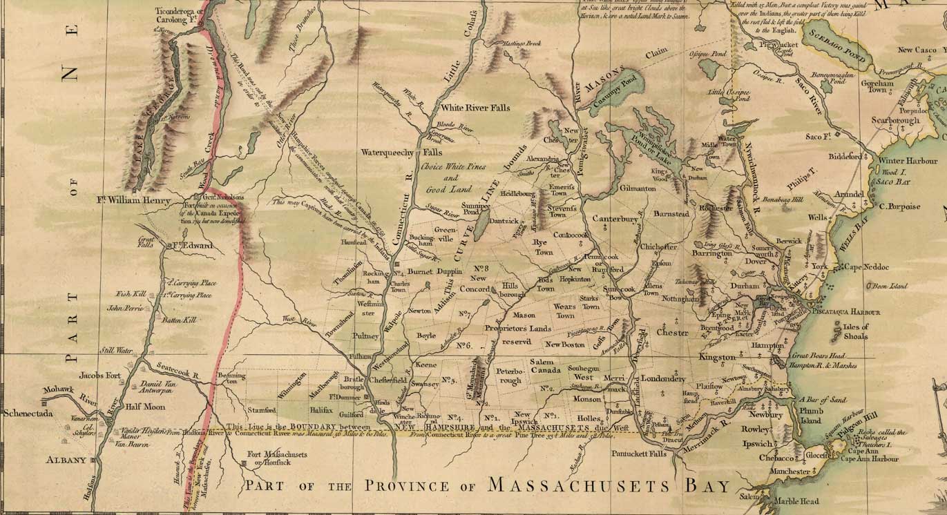
    If you search online you’ll find there are a couple of versions of the map available for  viewing.  The black and white version I have above, and a color version, a portion of which I show below.  The towns have mostly remained the same, with a few splitting into a multiple towns along the way.  The rivers are fairly accurate, which is notable since these were the superhighways of the day.  The map reaches as far west as Schenectady and as for North as Quebec.  This territory was ground zero in the French and Indian War, and the wars with the French that preceded it.  It would be important again during the early years of the Revolutionary War.  I’ve had the opportunity to travel most of this region over the years, and spend a lot of time writing about it in this blog.  So this map put a spell on me that I haven’t shaken loose from just yet.

    “The paradox of mapmaking… is that as soon as you begin shrinking a geography down to usable size, you necessarily are forced to misrepresent it. By making choices about what to include and what to leave out, you change the map from a document faithfully documenting an area to one furthering a particular point of view.” – Michael Blanding, The Map Thief

    Blanchard and Langdon created a map that clearly furthered a point of view, lending credence to Blanding’s observation. The history buff in me delights in reading it. Would it look the same if a Native American warrior had drawn it? Surely not. But the map no longer serves the purpose of furthering a point of view as much as it creates a snapshot of what the map’s creators were thinking at the time. Either way it’s a fascinating dance across time.

  • Downpours and Rainbows

    On Friday I drove through a downpour. A wall of water driving so hard to the ground that it looked like a thick fog as I drove into it. Rain so hard it creates whiteout conditions on your windshield. Cars around me reacted as I did by immediately slowing down, flipping the wipers to their fastest setting and a quick glance in the mirror to see what’s driving up on you. Some folks do better in this than others and like me keep going at a much reduced speed until it passes. Others, perhaps with vision problems or a less forgiving car pull over into the breakdown lane. Drive long enough and you’ll inevitably experience this a few times, and indeed I have.

    Ohio, 2015 driving a rental car from Columbus to Cincinnati I hit sustained rain so hard and steady that highway traffic came to a crawl. Worst I’d ever experienced. Even worse than Stockbridge 2011 on I-84 North approaching the Massachusetts border with intense, heavy sheets of rain pounding the windshield. I got to the rest area in Charlton and they were broadcasting tornado warnings. Sure enough one crossed I-84 shortly after I’d driven through that spot. I think back on my timing that day quite a lot, and look at where it crossed whenever I drive through.

    Back to Friday, and I-88 westbound through Otego. Down below 45 MPH for a stretch with blinding truck spray making it all but impossible to see. Pressing on the rain abated enough to improve visibility and then I was through the other side. Intense sunshine from the late afternoon sun replaced the rain and I quickly put on my sunglasses. Knowing this combination well I glanced in the rear view mirror and sure enough there it was. I smiled at the timing of the Wells Bridge rest stop approaching I pulled in and took a quick photo.

    They say things are darkest before the dawn. Friday offered a new twist on that, with the rain hardest before Mother Nature rewarded us with a rainbow. I’d paid my penance for the view, while those heading eastbound had the reward (the better view) first only to drive into the storm afterwards. There’s probably an analogy to explore there, but it’s best to be on my way.

  • Robert Treman and the Gorges

    I’ve never regretted a morning when I got up early and got outside to exercise. Today I’m moving Emily home from college so that meant an Ithaca waterfall walk. Different hotel than last time I was here, but fortunately there’s a stunning waterfall seemingly on every corner in this town. Five minutes walk from the downtown Hilton Garden Inn is the lovely Cascadilla Gorge Trail. As with most gorges, this one has plenty of water.The lower part of the Cascadilla Gorge Trail begins Treman Triangle, a small triangular shaped park named after Robert H. Treman, a local gentleman and successful Ithaca businessman who, along with fellow trustee Henry Woodward Sackett donated this Gorge to Cornell University.  But Treman didn’t stop with this gorge.  He also donated the land around Buttermilk Falls State Park and the park named after him, the Robert H. Treman State Park.  This is the type of wealthy guy I admire: make a lot of money and then do something good with it.  These were his time capsules, preserving the things he loved about Ithaca so that they might be enjoyed by generations long after he’s gone.  He’s remembered far more for the land he donated than for his success in business.  Isn’t that a greater success story than what he had accumulated in his bank account?

    I started writing today’s post thinking I was writing about Cascadilla Gorge and my observations about it.  It’s truly beautiful, and walking alone through it at 6:15 AM I felt like I was up in the Adirondacks somewhere, not walking up from downtown Ithaca to the Cornell campus.  My step-father went to Cornell and Cascadilla Gorge has a special place in his heart. Walking it while the city slept I could feel it. There’s magic in solitude, especially magnified in a spot like this.  Lingering here felt appropriate, but I was approaching this as exercise and aside from taking some pictures along the way I tried to keep moving.  As with most places I try to know something about where I am, which led me to a greater appreciation for Robert Treman.


  • Time Capsules

    A couple of weeks ago I stopped at Rogers Island Visitor Center in Fort Edward, New York.  I knew the place wasn’t open but I wanted to at least stop for a moment, look around and give a nod to the legacy of Robert Rogers, who used this island as a launching place for much of the fighting his Rangers did during the French and Indian War to the north of this place.  Rogers Island is strategically situated on the Hudson River and well known to the Native American, French, British and Americans who travelled these waters to “The Great Carrying Place” where you’d need to portage your canoe or Bateau boat on your trek to Lake George and points north.

    Rogers Island is considered the birthplace of the US Army Special Forces and holds a special place in the hearts of US Army Rangers to this day.  I wasn’t in the Rangers myself, but recognize the significance of the tactics developed by Rogers.  They essentially mirrored the tactics used by Native American warriors and added a few wrinkles of their own.  That’s a post for another time.

    While walking around I spent a few minutes reading the historical signs placed around the property and considering the commemorative garden that was just starting to bud on the April day I visited.  My eye was naturally drawn to the monument dedicated to those who fought and died in wars engaged in by the United States and I walked up to better view it.  While there I noticed the tablet on the ground marking the time capsule commemorating the 250th anniversary of the French and Indian War.  This capsule is scheduled to be opened in the year 2055.

    Time capsules are a message to future generations.  Schools do these all the time, and add things that are meaningful to the people who are participating in the event.  But the funny thing about time capsules is that in all likelihood you won’t be around when they open it.  Sure, 50 years gives you a fighting chance, but life is full of twists and turns and there’s no guarantee of anything except death.  So burying the artifacts of life is akin to a message in a bottle thrown in the ocean.  You’ll likely never see it again, but you hope that someone will and whatever message you give to them will be meaningful in some way.

    Time capsules are all around us, and you don’t have to bury some safe in the ground to make one.  My time capsules to future generations are the lilacs I planted along the property line, or the trees I planted out front.  They’re the bathroom I renovated in Pocasset and the words I’m writing now.  By this measure I look for similar offerings from those who came before me. Mostly my time capsule is the way I conduct myself and how that influences others for the better or worse as others continue to influence me.  I won’t be here forever but I hope my legacy will be positive beyond the generations who actually know me.  Time will tell, but it won’t tell me.

  • Asking for Directions

    Driving back home after getting my car serviced my trip was detoured for road construction.  Orange signs directed me to a new route, which of course I knew already having lived in the town for 25 years.  During this adventure it occurred to me that I haven’t been asked for directions in years.  The reason is obvious of course; everyone carries directions with them in their pocket.  GPS apps like Waze get you where you need to go, and tell you how much time you have left to your destination.  Where once we asked a person for directions, now this information is readily available.

    I stopped at a rest area a few weeks ago in Vermont.  The rest area attendant and I got to talking a bit about local historical landmarks.  I mentioned I was driving to a meeting near Lake George, had stopped at the Hubbardton Battlefield Memorial and was going to check out the fort when I got to Lake George.  He mentioned the tablet marking the location of the Battler of Fort Anne at Battle Hill, and gave me specific directions on what to look for as I was speeding along at highway speed.  I didn’t ask for directions, but they sure came in handy in spotting the tablet.  There are some things better left to humans to explain.

  • Iceberg Season

    This morning I was thinking about icebergs.  It’s iceberg season in Newfoundland, with more than 1200 released from sea ice and parading past the ruggedly beautiful eastern coast.  Icebergs are big business as tourists flock to see them, much as tourists flock to see Great White sharks now on Cape Cod.  The world has a curiosity about icebergs that goes back to the day the Titanic sank.  There’s something mystical and romantic about these roaming islands of ice marching from their icy prison in the north where they’ve been locked away for millennia to southern waters where they reunite with the blended waters of the world.  Romantic until you run into one anyway.

    Scanning the iceberg sightings this year made me think about my time on Signal Hill in December of 2017.  Signal Hill is impressive without the draw of icebergs floating by you, I can imagine the crowds there on a Saturday with an iceberg floating by.  My time there, documented early in this blog’s history, was memorable but certainly not crowded.  Little did I know at the time that I wouldn’t be back there again any time soon.  It remains on my short list of places I’d love to get back to.

    Environment and Climate Change Canada tracks iceberg activity and states that most of the icebergs that you see in the North Atlantic are calving from glaciers in Western Greenland, with between 10,000 and 40,000 icebergs annually.  I had no idea there were that many in a season.  To be categorized as an iceberg the ice has to be at least 5 meters above the sea level.  That’s the starting point, and icebergs get much bigger from there.  Those that miss the 5 meter cut are still navigation hazards.

    So icebergs triggered my wanderlust affliction, which is always lingering just below the surface.  Surely a trip to Labrador and Newfoundland in April would be a great mix of Aurora Borealis and icebergs.  Frankly I wonder why I haven’t done this trip already.  So much to see and do in this world, and two things I’ve always wanted to see are just out of reach this season.