Category: Travel

  • Starting Again

    I started a new job two weeks ago, which coincides with my last post on this blog.  It’s not that I didn’t have the time, it’s that I didn’t have the focus.  I was starting again, and there’s a lot to think about when you start again.  New processes, new names and faces, new technology to learn, new relationships to build and old relationships to re-kindle.  When you sell technology some people want to dance, and many others don’t.  My last company had a lot of the latter.  I saw it early but wanted to see it through.  My reward was some interesting travel but not a lot of money.

    Money.  I went to my previous company because I was running away from a dead end and chasing the big money.  Bold claims of big commission dollars and what looked like a strong and differentiated product.  But the timing was bad, the market said no thanks and so here we are.

    In a better place, with a culture of longevity and great leadership.  Drinking from the fire hose, but mostly around product differentiation and such.  The rest I know.  I’m starting again, but its not such a climb this time.

  • Wentworth-Coolidge Mansion

    The first Governor of New Hampshire was a real character.  Benning Wentworth Colonial Governor from 1741 to 1766, granted the governorship by Great Britain to settle a business deal with Spain that went south when the two countries got into one of their many disputes.

    As Governor, Wentworth had a damn the torpedoes approach that fits well with the Live Free or Die state motto that was adopted later.  One of the most controversial things Wentworth did was grant land in what is now Vermont to settlers, even though New York claimed the land as theirs.  Naturally this eventually led to hostilities between the two, most famously with Ethan Allen.  That’s a story for another day.

    Wentworth requested that a capital building be built in Portsmouth, but the New Hampshire General Council denied his request.  So Wentworth built a council chamber at his 100 acre farm instead.  It was here that he did most of the governing of the state.  It’s also where he sprung another controversy on his guest one night when, as a widowed 64 year-old, he married his 23 year-old servant.  It seems Wentworth was a player.

    The farmhouse is actually four or five buildings tacked together.  According to the Wentworth-Coolidge mansion web site, “The property became the center of political and social life in the colony. The Mansion is historically significant as the only original surviving residence of a Royal Governor in the United States”.  Interestingly, the first lilacs planted in the United States were planted here and the oldest in the country.  So New Hampshire has potatoes in Londonderry and lilacs in Portsmouth as two firsts.

    The house was eventually sold off a couple of times, remaining a farm for some time but gradually falling into disrepair until it became the summer house of John Templeman Coolidge III in 1886.  The Coolidge family, wealthy Bostonians, restored the property and likely saved it from oblivion.  The family hosted wealthy friends and artists from Boston each summer, and the area thrived.  His widow donated the mansion to the state in 1954.

    Today the property is a state park, surrounded by some pricy real estate.  I did a first day hike here to mark the New Year, 2018.  It’s a property I’d love to explore sometime, and dig into the history a bit more.

  • March

    March

    The full moon tonight brings with it a different kind of sky watching.  The wind and dropping temperatures signal a front moving through.  The clouds at 10 PM are wispy, but there’s a haze developing in the sky and it won’t be long before it’s overcast.  We have weather moving in.

    Going out for a walk when you’ve settled in after dinner is a mental hurdle akin to getting up and doing a workout.  You’re always happier for having done it, but every day is a test of willpower.  Bodhi is a creature of habit though, and that’s usually enough to push me out the door.  Thank you for that Bodhi.

    The breeze sounds different in winter than it does in the summer.  The oaks, maples and poplars are still bare and largely silent save for the clickity-clack of high branches fighting for space.  In winter the white pines sing alone with the breeze.  Pine needles shush like a parent coaxing a baby to sleep.  Ponderosa Pine needles in the southwest are bigger and make an assertive shushing sound in the wind.  Eastern White Pines, with their smaller needles and taller reach for the sky, offer a hushed shush.  Some of the trees in my neighborhood are mature, likely in the 120-130 foot range.  And at these heights the needles tango in the breeze, producing the nights music.

    The full moon backlights the clouds as they sprint across the sky east to west, offering a muted kaleidescope of white, grays and navy blues.  As the haze develops so too does a halo around the moon.  There’s an old expression; “ring around the moon means rain soon”.  Rain is certainly in the forecast.  It seems our ancesters know what they were talking about with those expressions.  In this developing haze, most stars concede the night to the moon, but Sirius, Procyon and Capella hold their own.  Such is the sky on this March 1st evening in New Hampshire.

  • Finding a New Routine

    Finding a New Routine

    When Bodhi was younger we would easily cover three or four miles in an hour walking every night.  We were both power walkers, and we had a rythym and pace that we both understood and enjoyed.  Bodhi was clearly burning more calories than I was because in addition to keeping pace with his walking his tail was wagging like crazy the entire time.

    Fast-forward to today, and Bodhi’s pace has changed dramatically.  He’s more inclined to stop and sniff, mark his territory, or really anything that stopped the walk so he could catch his breath.  He’s getting older and walking becomes much more of a process than before.  I’ve learned to accept this, and appreciate our time together more than I did when we were younger and I didn’t fully understand what we had.

    Since Bodhi isn’t walking as much, I’ve found that I’m not walking as much either.  Worse, since I’m not outside pounding the pavement at 9 or 10 PM, I’m replacing that exercise time with television or reading with a drink and snack.  Or sometimes just a drink.  Or two.  Not a good routine for a weeknight, so I’m finding a new routine.  I’m getting back outside to walk, even if alone.  I’m getting up earlier to row when I’m home, and walk when I’m traveling.

    Of course, routines don’t just happen.  They start with the first step on the first day and go from there. The trick is overcoming inertia.  When I rowed and we started the spring sprint races from a dead stop we’d do three rapid, short half strokes to get the boat moving, then progress to a full length and a high stroke rate for twenty or thirty strokes.  This has the desired effect of getting the boat to full speed.  Once you get moving you then settle into more manageable stroke rate for the body of the race.

    Routines are like that too.  Quick, relatively easy burst of activity to get yourself going followed by an increase in intensity and then settle into a sustainable level of activity.  That’s the kind of routine I need to be engaged in now.  Now would be a great time to start.

  • Common Periwinkle

    Common Periwinkle

    Consider the common periwinkle.  It lives a life relatively invisible to humans, unless you happen to be on the coast in New England anyway.  Even then most people wouldn’t think anything of these creatures.  And why not?  The Common Periwinkle lives a modest life fixed to rocks or marsh grass, scarping and eating algae and hoping not to be eaten by predators.

    The Periwinkle (let’s drop the common, shall we?) is a survivor.  Its foot clings to rocks as waves crash and swirl around and on top of it.  At low tide they’re exposed to extreme temperatures.  At high tide they’re underwater for hours at a time, all while whelks, fish and even humans hunt you down to eat you.  At low tide I’ve accidentally stepped on periwinkles, and honestly a feel a little sad about it.  Life is a strange thing, and it’s easy to feel small in this world that we live in, looking out at the universe.  And yet the periwinkle offers a little perspective.  We’re small, but there are many creatures smaller than us.  Life can be challenging at times, but hey, I’m not clinging to a rock getting battered by waves while I scrape off my algae meal.

  • The NJ to NH Run

    As a road warrier, I’m used to long drives.  Honestly, I don’t even blink when I drive 6-7 hours anymore.  The one exception to that is the drive back from New Jersey to New Hampshire.  The timing of the drive is critical, and so is the weather.  This afternoon neither worked in my favor.

    From New Jersey, there are basically two viable options over the Hudson River; the Tappan Zee Bridge or George Washington Bridge.  When you drive over the GW you assume the worst, no matter what time of day it is.  Heavy traffic and a rough and bumpy road surface are a given 90% of the time.  Usually crossing the GW means placing all your chips on I-95 all the way to New Haven.  That’s a scary bet.

    The Tappan Zee is less predictable, but generally lighter than the GW.  I’ve always found it to be an interesting and enjoyable bridge to cross, largely because of the width of the Hudson at this point, and the beautiful cliffs that line the shores, particularly at Hook Mountain State Park.  The challenges come after you cross the Hudson.  You either roll the dice on the Sawmill Parkway or on the Merritt Parkway.  Parkways sound lovely, but they’re narrow, unforgiving roads built at a time when cars were driving 35-40 MPH.  Quaint.  Of the two parkways the Merritt is more appealing, with rest areas, a tunnel and importantly, no traffic lights.  The Sawmill has multiple traffic lights along the parkway, which puts the park in parkway.

    From the parkways you’ve eventually got to get through or around Hartford before you finally catch a cruise control breather on I-84 from Manchester, Connecticut to the Mass Pike.  This moment of bliss is usually interrupted by the realities of the Pike.  Channeling thousands of drivers from from parts west with thousands of drivers from parts south can lead to epic traffic on the turnpike.  Summer and holiday traffic is especially delightful along this stretch of Americana.

    Life at highway speed isn’t all its cracked up to be, but its still better than bumper-to-bumper speed.  The math has never worked taking the train or a plane to New Jersey.  So we all enter the grinder and hope for the best.

  • Mount Hope Bridge

    Bristol, Rhode Island is home to the first and thus oldest 4th of July parade in America.  The stripe down the middle of the road is red, white and blue.  This town is patriotic and quaint.  It’s home to Roger Williams University and the America’s Cup Museum, but my favorite thing in this town is the bridge between Bristol and Portsmouth.  The Mount Hope Bridge is a two lane suspension bridge over Narragansett Bay.  It’s a tall, narrow bridge that runs 135 feet above the high tide mark.  There are no sidewalks on this bridge – one lane each way at no wider.  It’s on the National Register of Historic Places because there’s quite a history to it.

    The Mount Hope Bridge was proposed in 1920, supported by the wealthy and influential William Henry Vanderbilt III and finally completed four days before the 1929 Stock Market crash that started the Great Depression.  It’s named for the bay that it spans, which in turn is named for the 209 foot hill Mount Hood.  There’s incredible history in this area.  The Wampanoags held meetings at a rock formation called King Phillips Seat near Mount Hood.  Thankfully this is preserved by Brown University, which owns the land in that area.  That history is a blog (or a few blogs) for another day.  Today is about the bridge.

    Timing the ride over the bridge well, you may be lucky enough to see a spectacular sunset over Narragansett Bay and Jamestown.  It’s one of the rare times when I wish there was traffic so I could just watch the sunset.  Sadly there are no pedestrian walkways on the bridge, though in theory I could ride a bike across the bridge.  In practice that’s a scary thought.  The lanes are narrow and there isn’t much forgiveness between moving vehicles and the bay.  I’m not risk-averse but that doesn’t seem like a recipe for success.

    I’ve had an affinity for bridges for a long time.  It may have been all those trips across the Sagamore Bridge going to the Cape as a kid.  It may have been those long rows from Lowell to the Tyngsboro Bridge in college.  Or memorable trips across the Brooklyn Bridge, Golden Gate Bridge and recently the Vasco De Gama Bridge in Lisbon.  Beyond their utility and architectural beauty, bridges represent connection.  The Mount Hope Bridge may be named after a hill, but I prefer to think of the name as nod to optimism.  Connection and Hope.  We could use more of each in this strange world we live in.

  • Dogtown

    New England is deeply rooted in its colonial past.  Walking through the woods in most towns in the area, you’ll come across miles of stone walls, old cellar holes and forgotten road beds.  But there is no walk in the woods quite like Dogtown Common.  I had an opportunity to take a walk through this abandoned village yesterday, a bright February Tuesday.  While it was a beautiful day for a walk in the woods, I didn’t see another soul in the two hours I spent there.

    Dogtown is located in Gloucester, Massachusetts, right on the edge of the town of Rockport, on Cape Anne.   It was once a small community of settlers who cleared and farmed the land as so many other communities did in New England.  Unfortunately, they chose a tough spot for this.  As the name Rockport indicates, this area is basically arid piles of loose granite sitting on top of ledge, sprinkled with some dirt.  Once the trees were cleared and the livestock grazed the remaining vegetation to the ground, there wasn’t much left to work with.  Compounding things, Dogtown was sited in an exposed area near the sea, making it an easy target for the British in the Revolutionary War and the War of 1812.  So over time residents moved on, abandoning the area for easier living elsewhere.

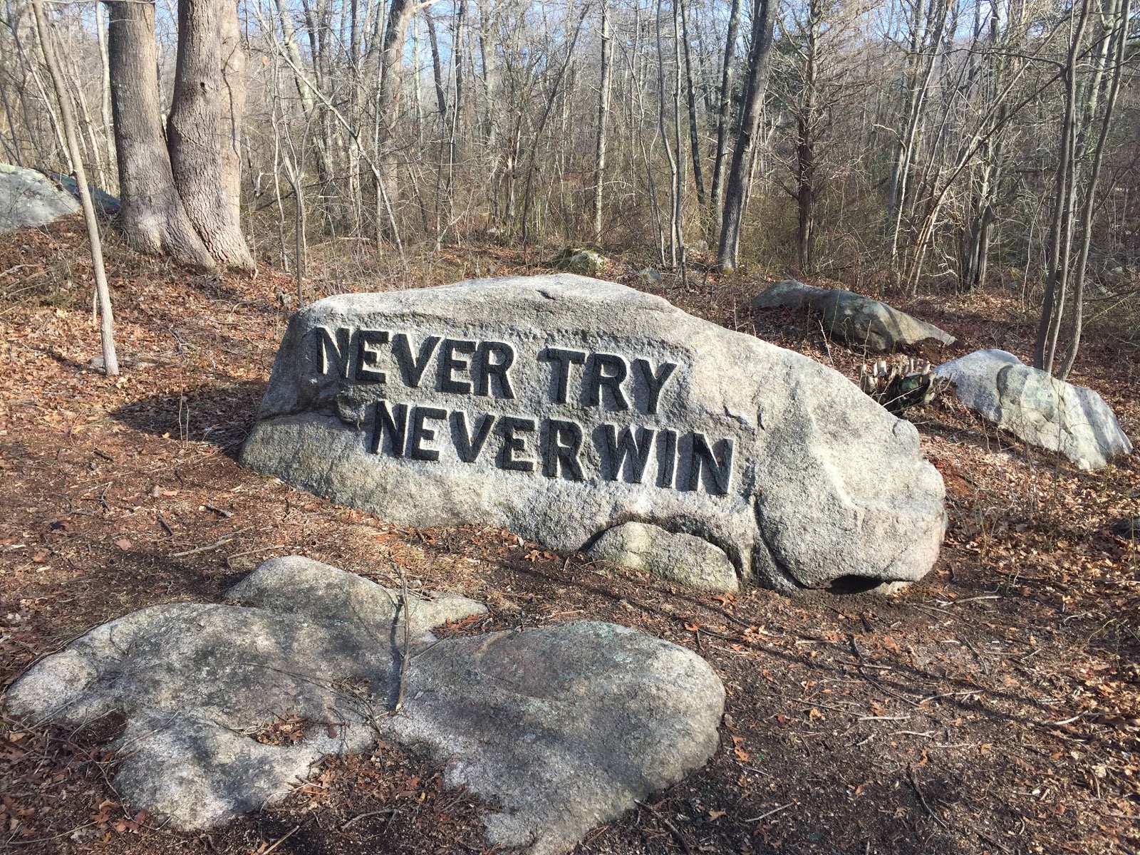
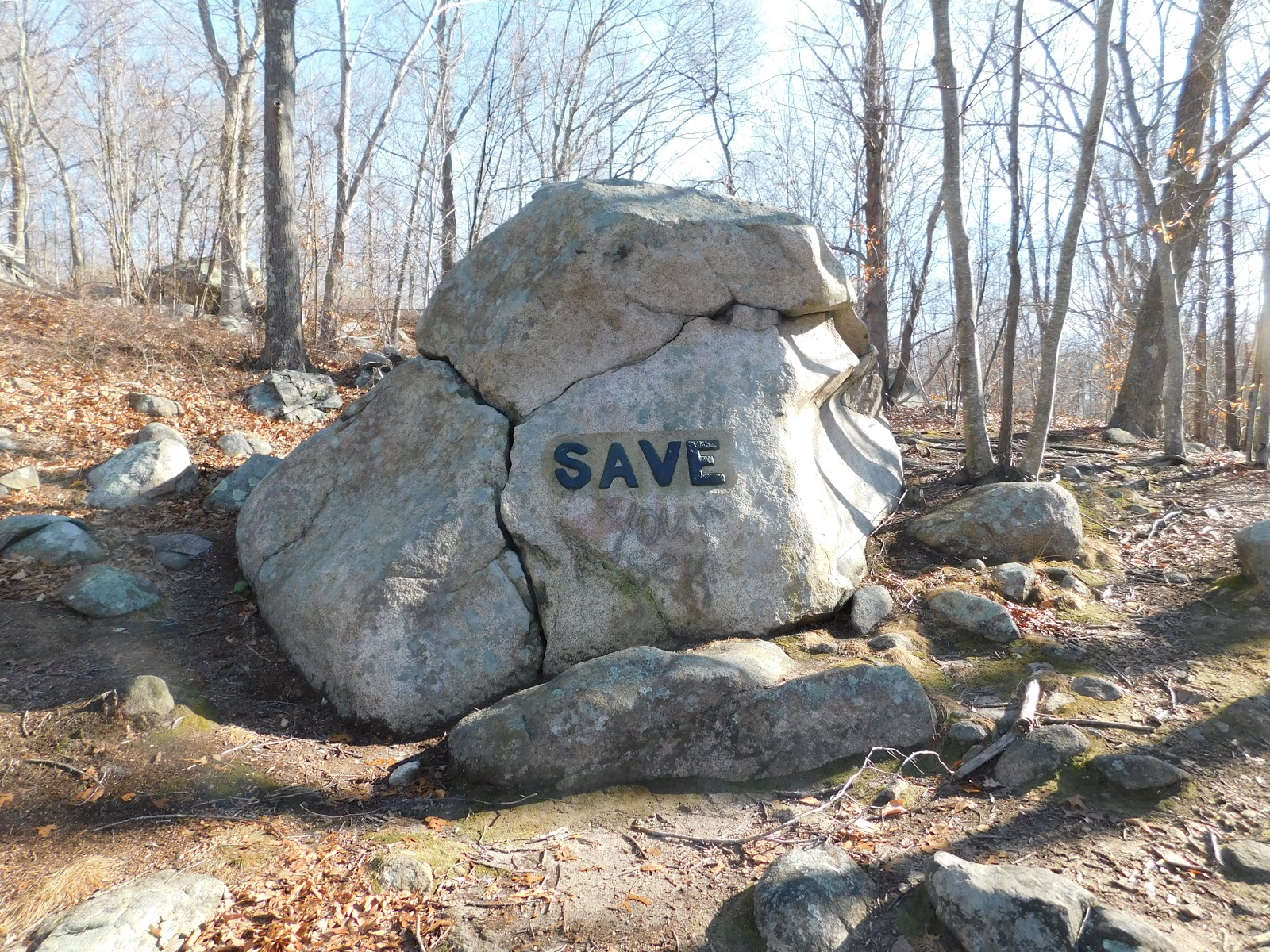
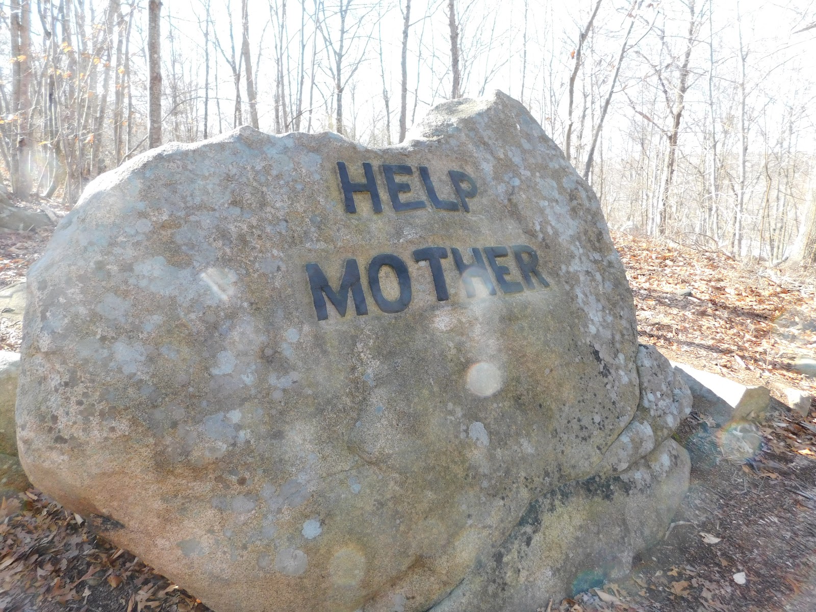
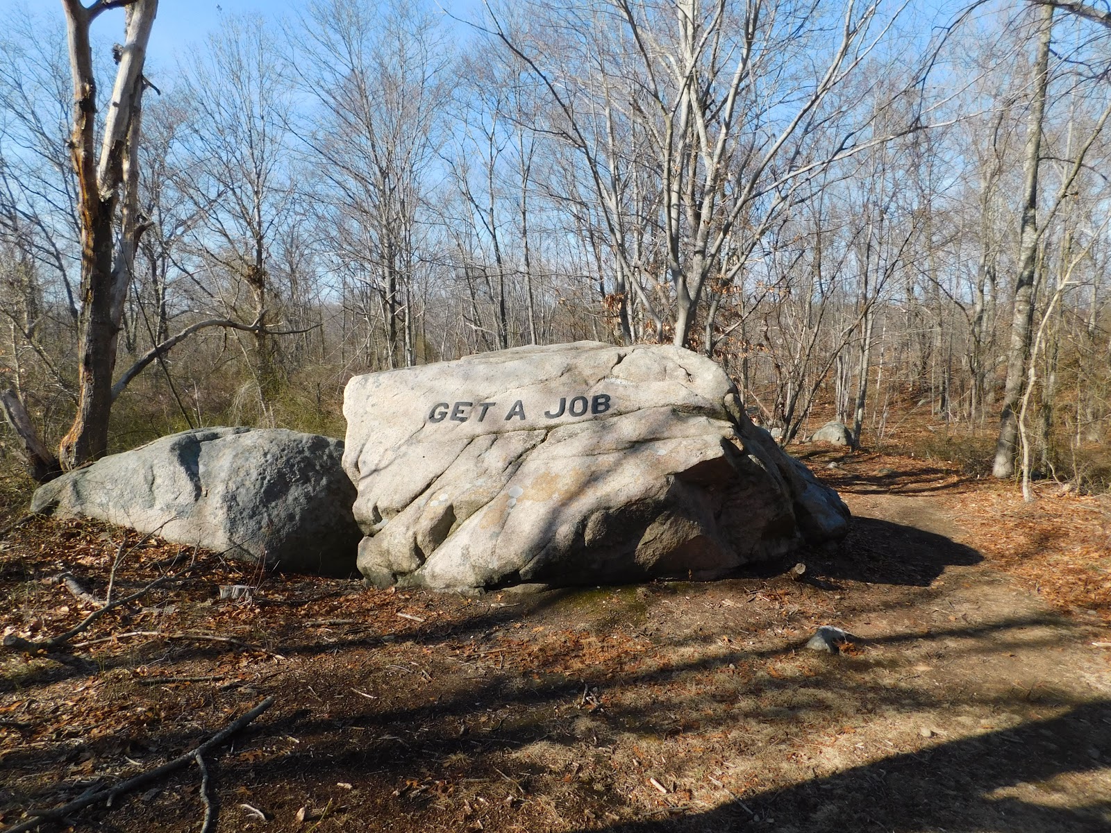
    Sheep continued to graze in this area into the early 20th century, but as with so much of New England    the farmers and herders passed on, leaving the land to return to the woods.  Dogtown 100 years ago was a rocky land sprinkled with grass and shrubs.  Today it’s a forest with a bed of boulders, ledge, old stone walls and cellar holes, similar to what you’d see in forests throughout the region.  What makes Dogtown unique is the work of Roger Babson, who commissioned unemployed stonecutters to carve words and numbers into the granite boulders that litter Dogtown.  Babson was an interesting guy; he was a Prohibition Party member, he predicted the market crash that led to the Great Depression, and he founded Babson College.  As a tenth generation Babson from Gloucester Dogwood Common was figuratively in his blood.


    Walking through the woods of Dogtown on a bright winter day, the work of Babson resonated with me.  I chose a Tuesday when most people are working to visit, and had the place to myself.  Aside from seeing mountain bike tire prints, the sounds of commuter trains on the tracks that cut through Dogtown and the sounds of construction encroaching on the woods at the nearby office park betraying the current century, my visit was timeless.  The stonemasons and the settlers to this area have come and gone from this place and it was my turn, alone amongst the boulders.
    Babson spoke to me from the past with his choice of words and phrases carved into the boulders.  “Get A Job” is highly relevant for me as I leave the struggles of one job for the hope of another.  “Truth” challenges me to be honest with myself about where my own strengths and weaknesses lie.  “Courage” shoves me in the chest and knocks me back a step, urging me to be bold today.  And “Prosperity Follows Service” reminds me that to earn anything worthwhile you’ve got to give much more of yourself.  While some view the messages as a strange curiosity, Babson’s boulders for me are a humbling reminder of what I can be.
    I came to the woods knowing of this place.  Perhaps because I was alone on this brilliant winter day, or maybe because of the place I’m at in my own life, but Dogtown resonated as I walked its quiet paths.  They say that when the student is ready the teacher will appear.  Maybe it was the woods, with voices of the past whispering in my ear as I walked.  Maybe it was me moving on from one job to the next and working that through in my mind.  Or maybe it was a message from a tenth generation Gloucester Babson who died a year after I was born.


  • Ambient Light

    Last night was one of those nights you hope for when you’re a stargazer.  Brilliantly clear skies, with cold air providing sharp focus.  Just a quick glance at the sky showed old friends Orion, Ursa Major and Ursa Minor, and down low in the southern sky, Canis Major with the brilliant Sirius a beacon on the constellation.  Sadly, the neighborhood was lit up like a prison yard as several of the neighbors chose to leave their outdoor lights on.  Another celestial show foiled again by the neighbors…

    I seek out the sky, and often walk looking up, sometimes started when I step off the pavement onto the shoulder of the road.  I once sailed from Norfolk, Virginia to Newburyport, Massachusetts, and eagerly watched the night sky when we were well offshore.  Cape Cod in winter offers some good viewing.  Any large body of water serves to subtract ambient light, simply because there usually aren’t lights shining there.  A favorite place in southern New Hampshire is Big Island Pond, where many a late night boat ride was spent marveling at the night sky.  Another spot I have fond memories of is the Robert Frost Farm in Derry.  Back in the late 1990’s I joined a couple of friends for a late night viewing of the Hale-Bopp comet in these Frost fields.  I think old Bob would have approved and joined us for a turn at the telescope had he been alive.  The next comet will be Halley’s Comet in 2062.  I would be 96 in 2062.  I hope I’m around to see it, and have my wits about me to recognize it.

    In search of dark skies, I came across The International Dark Sky Association, which lists Mont-Mégantic (Québec) as the closest, and first-in-the-world, International Dark Sky Reserve.  I’ll confess I wasn’t aware of this distinction prior to today.  Mont-Mégantic is roughly a four hour drive, directly through the White Mountains of New Hampshire, past the Connecticut Lakes region and into Quebec.  This region is familiar country for me.  I’ve visited the area to see moose, canoe on First Connecticut Lake and see and hear loons.  It’s an area that stays in my memory even after a quarter century.  If I was going to pick a part of New England that would have the darkest skies, this corridor between Franconia Notch and Pittsburgh would be on the short list.  Shifting northeast into Maine, I’d pick the Hundred Mile Wilderness along the Appalachian Trail as a likely dark sky candidate, and of course the unnamed wilderness to the north.

    Curious about where the darkest places in New England actually are, I came across this helpful site called Dark Sky Finder, (http://www.jshine.net/astronomy/dark_sky/index.php?lat=40.384212768155045&lng=-74.300537109375&zoom=8).  As this image shows, the darkest areas are in the north-easternmost corner of New Hampshire northeastward through a large swath of remote wilderness in Maine between Baxter State Park and the Allagash Wilderness Waterway that runs along the Canadian border.

    It was an easy guess picking the wilderness of Maine as the darkest skies in the northeast.  My memories of hiking the Hundred Mile Wilderness aren’t filled with a lot of ambient light.  Another memory comes to me.  The first time I hiked the Appalachian Trail through Mahoosuc Notch I was in my early 20’s.  A bunch of us set up camp at the Speck Pond Campsite, had dinner and swapped stories from our day through the Notch.  After dinner we hiked halfway up the trail to Old Speck Mountain and settled in for star gazing.  There was a meteor shower that night and the clear dark skies gave us the perfect canvas for a stunning show.  That night is what I think about when I look to the skies.  I guess I’m still chasing stars.

  • What’s in a Name, Part II

    Driving through the Southern Tier in Upstate New York is like time travel in slow motion.  You can see the change that time brings.  The wooded hills aren’t as tall as they were when the Oneida and Mohawk tribes ruled this land, but the woods have re-established themselves in many areas.  And with the trees the whispers of the mighty Iroquois Confederacy float through the valley.  The  Mohawk, Onondaga, Oneida, Cayuga, Seneca and Delaware tribes that populated Upstate New York will never return, but in some ways they’ve never left.  Their names live on as counties, towns, rivers and other place names like monuments to the tragic past of disease and violent displacement that stole them from these lands.  The remnants of the Seneca Nation reside mostly in three reservations in the area.

    Place names may honor our own past or be borrowed from those who came before us.  Towns and villages are often named for the settlers who first cleared and farmed the land, or to honor a notable person from the time, like Washington, Franklin, or Madison.  Upstate New York was settled at a time when names pointed towards Greek or Roman culture or mythology.  Ithaca, Greece, Rome, Ulysses, Syracuse all point to this practice from the 1800’s.  Perhaps the best story of the randomness of naming a town comes from Utica, where the name was literally pulled out of a hat.

    Today’s rural Upstate New York is dominated by corn and dairy farms, but the life of a farmer is difficult, and many of the old farms are returning to the land.  Rotted and falling barns and silos dot the land.  Farmhouses advertise the poverty level of the region with flaking paint, sagging porches and and blue tarp roofs.  Villages along Route 206 like Whitney Point, Triangle, Greene, Coventry and Bainbridge proudly point to their roots between the Revolutionary War and the War of 1812 while looking towards an uncertain future.  Technology or population growth may one day bring growth and prosperity to this region, but I hope the land returns to nature and the names fade like whispers on the wind.