Category: Travel

  • Chasing Waterfalls

    I seek out waterfalls.  And sunrises… and sunsets… and just about anything else that makes magic out of the ordinary.  If I’m in a place with something to see then, well, I’m going to try to see it.  I’ve chased down steamed cheeseburgers in Connecticut, lighthouses in Maine, Heady Topper in Vermont and driven halfway across Portugal to see the end of the world. Like Thoreau, I want to live deep and suck the marrow out of life.

    Today I found myself hunkered down in a hotel in Ithaca, NY.  For a snow town they do a lousy job plowing this city during a storm.  Ithaca is known for its hard winters, its hills, and its gorges.  And of course the gorges are where you’ll find the waterfalls.  Like this one, Cascadilla Falls, from the creek that bears the same name.

    It’s no wonder Cornell chose this location for his land grant college.  Ithaca is unique and interesting, and largely undiscovered for me.  Driving around gives you a sense of this, but there’s no substitute for walking.  Even if walking today meant shuffling through eight inches of snow on uncleared sidewalks.  Sometimes living deeply is more work than at other times.

    There’s never enough time for these detours from the routine.  But I manage to squeeze in a few memorable moments each week.  I’ve grown to love Upstate New York over the years.  It’s more than cows and corn at 70 MPH on I-90.  I hope to convey that in future posts.


  • What’s in a Name?

    I live in Southern New Hampshire in a town that used to be part of Massachusetts.  Borders changed a lot back in the day.  The area I’m likely saw many turf wars between the Pennacook and Abenaki over the centuries.  Both tribes were part of the Webanaki Confederacy.  Webanaki means “People of the Dawn Land” because, well you know, they lived along the Eastern coast.  I think we should adopt that name again, both to honor the native population we displaced and frankly because it’s way cooler than “Yankee”.

    The name “New Hampshire” didn’t come along until 1629, when Captain John Mason, previous Governor of Newfoundland, split Northern New England with another well-connected gent named Captain Gorges and named the region between the Merrimack River and the Piscatagua River – you guessed it – New Hampshire.  Back then explorers and settlers didn’t venture too far into the wilderness, so Mason wasn’t envisioning the shape of the Granite State back then.  In fact, he never set foot in New Hampshire.  He died before he could sail over to check out his new stomping grounds.  But plenty of other folks did.  And of course, this brought violent conflict and atrocities hard to imagine today.

    There are hints to the past if you look closely enough.  Massacre Marsh in Rye, NH marks the site of a raid that killed 13 settlers.  Worlds End Pond in Salem NH once marked the end of civilization and the edge of the vast northern wilderness.  The Dustin Garrison in Haverhill MA was built to defend the region from Indian Raids.  It was a harsh, unforgiving world.  The people who settled here had to be tough, resourceful and resilient, or they simply didn’t survive.

    The name New Hampshire wasn’t an accident.  Mason had lived in Hampshire, England and it probably seemed like a logical choice to tack on New.  And the New World was looking for settlers, and naming the region after places familiar to the population back in the Old World was a nice marketing trick designed to entice settlers to drop everything they knew, risk life and limb sailing across the North Atlantic and find a piece of land to clear and farm.  And hopefully grow some food, hunt some game and fend off raids, wars and the brutal cold of winter long enough to put down roots.  New Hampshire, Nova Scotia, New Brunswick, New France, New England…  and on.  Most people never think about the names of the places they live, or the life and death struggles of the people who came before us.  The bones of the past are all around us, if we only open our eyes to see.

  • Portugal: The End of the World

    Started strong on this blog, then petered out as the realities of a job spiraling downhill combined with an irony-filled sales kick off meeting in Portugal left me with not much to say.  Which of course is not the case at all with all that going on.  I’ll work to be more consistent.

    The sales kick off meeting was the usual stuff that goes on when a company goes to great lengths to inspire a sales team.  Well prepared executives telling us how great things are.  Product Managers telling us how great things are going to be.  Sales awards for the past and optimistic spin on the future.  And a dose of ass-kissing and opportunistic positioning by the sleazy element.  Still, as with most companies the majority of employees are truly great people who work hard, are ethical and want to do good things.  I wish them well, and hope they clear the hurdles ahead of them.

    The real adventure in Portugal began when the meeting was over.  I drove from Lisbon to Sagres for some hiking along the coast, fresh seafood and time to reflect in a place completely new to me.  The drive down from Lisbon began on the extraordinary Vasco da Gama Bridge over the Tagus River, continued across a changing landscape of vineyards and cork tree groves that gave way to more arid climate as I approached the Algarve Region.  My destination was the end of the world.

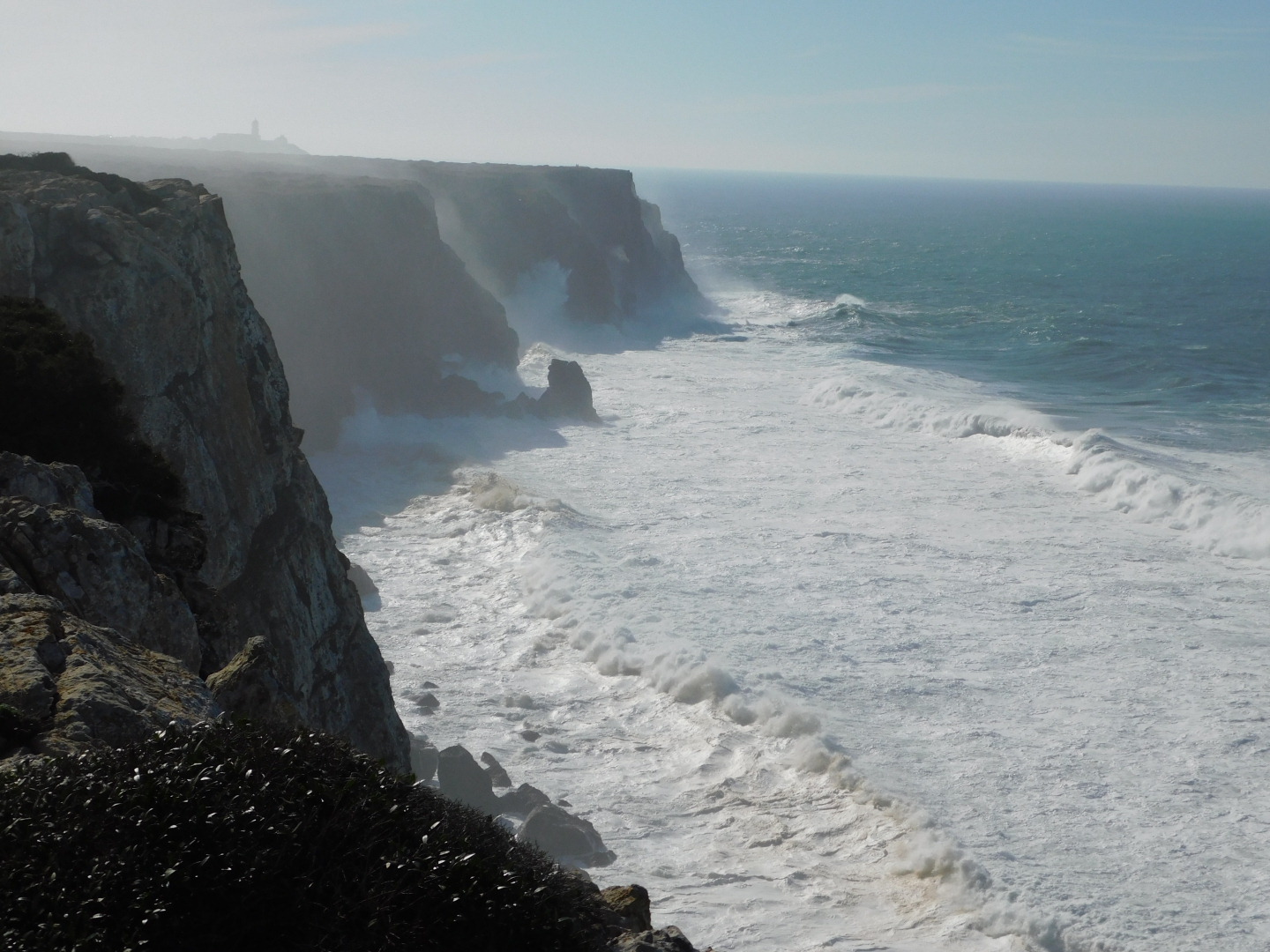
    Sagres was once called that – the end of the world.  The rocky cliffs of Cape St Vincent were the southwestern corner of “civilization”.  And no wonder they thought so.  The rolling waves of the Atlantic Ocean crashing into the cliffs of Western Europe certainly felt that way.  Ships rounding the Cape of St Vincent looked to the treacherous cliffs and prayed for favorable winds to keep them from being bashed against them.  Many of their prayers were unanswered and countless sailors perished along this coast.  Imagining the New World beyond the horizon was likely beyond the scope of many of the people living in the Middle Ages.

    Sagres today is a sleepy surf town, full of beautiful vistas and great seafood.  The world back then, as in many places, was a lot more violent and uncertain.  Sagres is incredibly rich in history.  Pirates and privateers raided this coast to rape and pillage and enslave those they didn’t kill outright.  Explorers setting sail from this region mapped the African coast, opened up the sea route for spice trade and eventually circumnavigated the world.  Sagres was the home and final resting place of Henry the Navigator (Prince Henry the Navigator – Wikipedia) who changed the narrow view of Europeans in this time and fueled the Age of Discovery.

    Hiking a portion of the Rota Vicentina in the offseason provided me with a glimpse into the past.  I was struck by the powerful waves of the Atlantic colliding with the sheer cliffs along the coast, and the splendid isolation as the trail moved towards the interior.  For much of my hike I was alone.  Fishermen and tourists were clustered at the lighthouse on Cape St Vincent, but after that I saw five other people on the rest of my 12 mile hike.  Offseason for sure.  Soon after passing the last of the fisherman precariously dangling their poles over the cliffs near Cape St Vincent I found myself virtually alone in the harsh, beautiful terrain.  The footing is challenging; alternating between red sand and sharp limestone and sandstone ready to trip and greet the careless walker who dares to enjoy the stunning scenery for more than a step or two before validating the path.

    Portugal, like Newfoundland, offers seclusion mixed with warm encounters with friendly people.  It’s still relatively unknown as a vacation destination, but that will change.  As indicated by the graffiti I saw throughout Portugal and the broken glass on the trail, not everyone embraces leaving no trace.  I hope that the cultural intolerance for these things increases in the years to come.  I fell in love with this place and hope it never becomes the overbuilt, resort-clogged destination that some other parts of the Algarve have become.

    And now I’m back, with memories, pictures and video of this incredible place.  As with all solo travel I felt the conflicting emotions of savoring the meditative qualities of going it alone with the longing to have shared it with family and friends.  Hopefully I’ll see you again Sagres.


  • Fogtown

    Fogtown

    A few weeks back, with time to kill before my flight home from Newfoundland, I drove to the top of Signal Hill and walked out to North Head.  Signal Hill offers stunning views of St. John’s Harbor and The Narrows, and East to the Atlantic Ocean.  It’s a place I’d love to linger at on a warm summer day.  But this was December, and the wind stung as I took in the view from the top of the hill.  Not a beach day at all, but the overcast skies cooperated enough to give me a view.  Looking out at North Head, I noticed a couple of red Adirondack chairs in two spots along the North Head Trail, cleverly placed to draw the eye, give walkers a place to rest a spell and at that moment to stir my wanderlust.  Not very far at all, perhaps 20 minutes or so, and despite the wind and the raw day I felt the urge to visit those chairs.

    In the time it took me to walk down the boardwalk stairs and out to North Head the fog that gives St. John’s it’s nickname rolled in fast and hard.  The last couple of people out on North Head hurried past me on their way back to their car, leaving me alone out on the trail, with visibility rapidly decreasing and nothing but the blaring foghorn marking the Narrows to keep me company.  That foghorn reminded me of the horns blowing on the Wall on Game of Thrones as the White Walkers approached, and frankly, I wouldn’t have been surprised to see one walking out of the mist towards me.  Or perhaps the ghosts of Leif Erickson, the lost-to-history Beothuk tribe, the French or British soldiers who fought here in the last battle of the Seven Years War or maybe just the countless tourists who stumbled away from George Street long enough to walk these cliffs before me.  

    Alone out on North Head with the fog swirling and the horn calling out its warning, it was easy to imagine them all marching by me, and the moment stays with me still, almost a month later.  I hope to visit St. John’s many times over the years ahead, but we all know that men make plans and God laughs.  Here’s hoping that fate brings me back for a longer spell next time.

  • Alexander’s Map

    Alexander’s Map

    A new year, and a new pursuit; this blog.  So why the name?

    Alexander’s Map is a rare map published in 1624 to encourage colonization of the lands granted to William Alexander.  The map gives an early, if inaccurate, glimpse at this region that I’m so fascinated with.  Alexander’s Map stretches from present-day Massachusetts to Newfoundland to the northeast and Quebec (“New France”) to the north.  
    My blog will cover observations from living in this region, and will also include observations from as far west as Buffalo and as far south as New Jersey.  This is where I spend much of my time, and with so much history, food, sports and geological and cultural diversity to explore it will be fun to explore this in writing.  I hope you’ll enjoy the journey with me.