Tag: Massachusetts

  • Bloody Brook

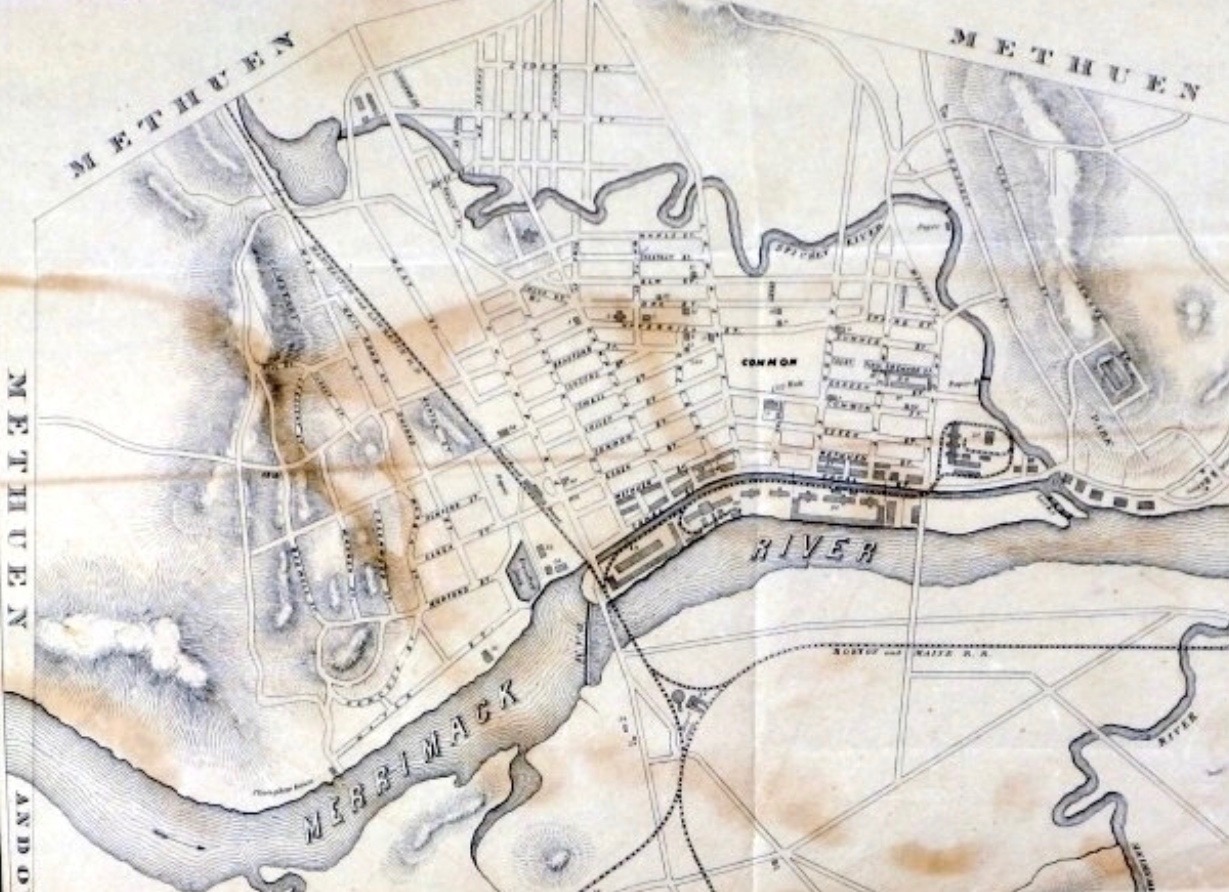
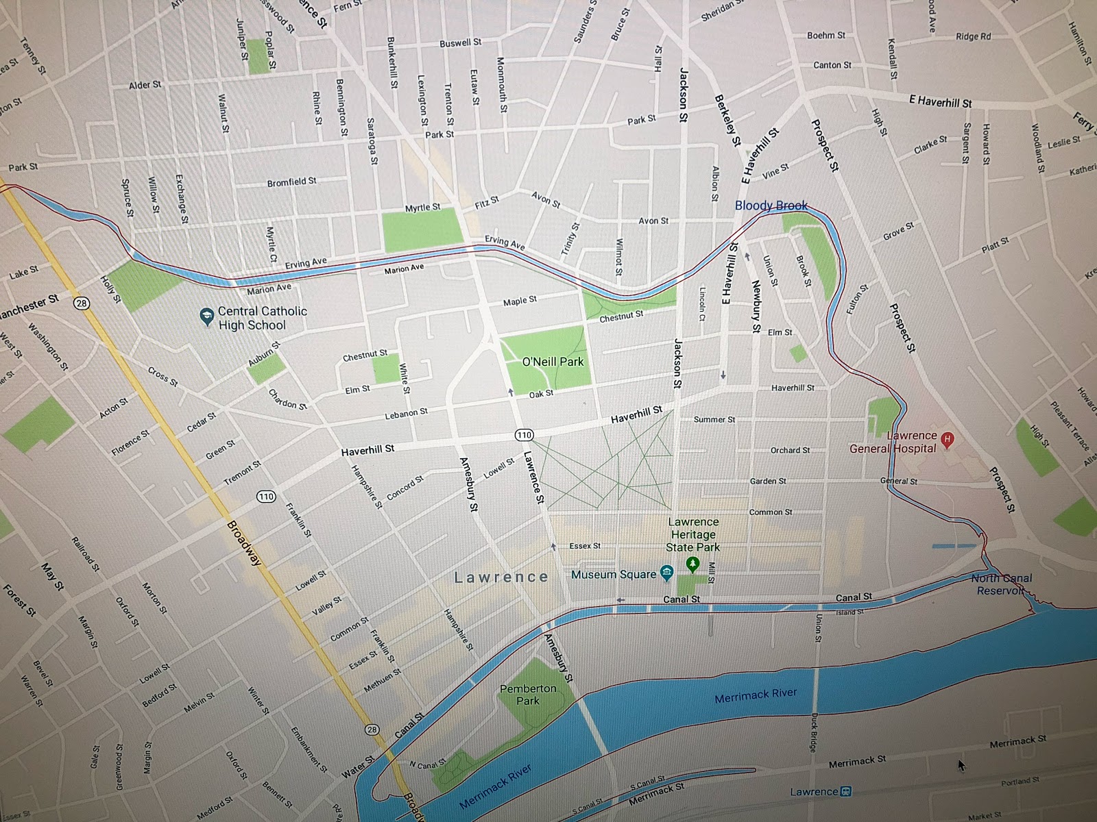
    There’s a tiny brook that flows from Searles Pond near Holy Family Hospital and feeds into the Spicket River just before it in turn feeds the Merrimack River in Lawrence.  It’s name betrays a violent history, long before Lawrence and Methuen become heavily developed urban environments.  Google has led me a couple of times to a very useful site that details the history of Methuen and some of the surrounding area that once was part of Methuen.  You can Magenweb here.

    The name Bloody Brook was said by George Frederick, late town treasurer and authority on Indian lore, to come from a terrific battle between the Agawams and the Tarrantines in the days before the English settlement. As near as white men could tell after they came, about September 1615 the Tarrantine Indians of Maine had a poor harvest so they invaded the Merrimack Valley to raid the fields,and naturally the local Indians resisted as best they could. It is said that clubs and stone axes, rather than arrows, were found in this area, indicating the closeness of combat. 

    The Tarrantines were part of the larger Mi’kmaq tribe of coastal Native Americans who lived from Maine to Newfoundland.  For them to make the long trip down to what is now Methuen to raid the fields of the Agawam speaks to their desperation.  There is another famous Bloody Brook that points towards the better-known history of conflict between the white settlers and Native American population.We hear a lot about the encroachment of European settlers in the area and the conflicts that arose with the Native American population as a result.  The conflict between tribes is a lesser known, but no less violent history of the land we live on today.  Names like this dot the map, just waiting for someone to remember the ghosts who once inhabited this land.


  • Straightening the Spicket

    Straightening the Spicket

    The Spicket River flows from New Hampshire into the Merrimack River in Lawrence, Massachusetts.  The river has changed over the years, particularly during the explosive development of Lawrence and Methuen in the Industrial Revolution.  By the late 1880’s the City of Lawrence had enough of the typhoid breeding ground that the river had become and decided to straighten the river.  Looking at the first map from the 1850’s followed by a Google map from 2018 you see just how much they changed the Spicket River in the Lawrence stretch.

    Unfortunately, they didn’t dig the channel deep enough and the river bed can’t handle the floodwater that were once absorbed by the natural flow of the meandering river that once flowed through the city.      Heavy rains combined with spring melt-off creates a flood plain that makes some areas of the city impassible.  Perhaps no place carries this burden more than Central Catholic High School, which sits right where the the flood plain once acted as a sponge for the river.  The city doesn’t seem to be in a hurry to correct the situation, so every few years there’s a lake where the CCHS parking lot once was.  The price of progress, or the price of poor engineering?

  • Boomtown: Lawrence, Massachusetts

    Boomtown: Lawrence, Massachusetts

    In 1845 the land along the Merrimack River that would soon be called Lawrence had a population of 104.  Five years later the population had exploded to 8,358.  By 1920 the population had swelled to a high of 94, 270.  All these people arrived in Lawrence as the river was dammed, canals were dug, brick buildings were constructed, and water was diverted to fuel the entire enterprise.  Water power moved everything, including the people who moved here for the work the mills provided. 
    Lawrence is ten miles downstream from Lowell, which was the most successful textile city in North America.  The Essex Company wanted to duplicate that success using the same Merrimack River water that Lowell used.  The first step was to build the great stone dam in Lawrence to better regulate the flow of water to the mills.  Next, as in Lowell, a power canal was built to channel the energy of that water to the mills.  This powerful water had to go somewhere, and it was directed through turbines that turned gears that turned leather belting that turned the looms that thousands of factory workers tended.

    And it didn’t stop with the loom workers.  The mills had to be maintained and grow.  The workers had to eat, and live somewhere, and go to church, and their children had to go to school.  Banks and hospitals and trolleys and parks and stores and houses and roads to connect it all grew like concentric rings out from the turbines.  Lawrence, like Lowell before it, became a boomtown.  Like Lowell, it thrived until cheap electricity and labor pulled textile jobs to the South and eventually overseas.

    Unlike Lowell, which has a major university and political clout in the Commonwealth of Massachusetts that enabled it to rebound more quickly, Lawrence was lost without the manufacturing jobs for decades.  The loss of jobs led to an exodus of many of the people who were the backbone of the community, and that void was filled with poverty, helplessness, riots in the 1980’s, insurance scamming in the form of staged accidents and arson, and drugs and crime led to Lawrence being one of the least attractive places to live in New England.

    And yet the bones of the city are strong.  There’s beauty in the mill buildings and homes that the textile wealth brought to the community.  Looking beyond the criminal element, there is a vibrant immigrant community that is family-oriented, hard-working and chasing the American dream.  Lawrence is a city poised for explosive growth, just waiting for the next economic turbine to power it all.

  • The Merrimack River

    The Merrimack River runs from the Lakes Region in New Hampshire to the Atlantic Ocean.   Source to Sea it’s roughly 117 miles long from the confluence of the Pemigewasset and Winnipesaukee rivers at Franklin, NH to the mouth at Newburyport, Massachusetts.  This stretch of river has served as a source of food, commerce and transportation for thousands of years.  Depending on who you believe, the name is derived from Native American words merruh and auke, which together mean “the place of strong current”.  The Merrimack lives up to that name.

    The powerful current of the Merrimack drew the attention of the Boston Associates, who expanded their manufacturing operations from Waltham to the Pawtucket Falls in what was East Chelmsford, and soon would be known as Lowell (named after the founder of Boston Associates, John Cabot Lowell).  The massive success of the textile mills in Lowell was quickly duplicated in other locations along the Merrimack, sprouting the cities of Lawrence and Haverhill in Massachusetts, and Manchester and Concord in New Hampshire.

    The explosive growth of colonial expansion and then the textile industry transformed the Merrimack River from sleepy Native American fishing villages to massive red brick cities connected by an increasing network of roads.  Dams and canals have changed the flow of the river and impacted the migration of salmon.  In many ways the river has changed forever from what it was in the early 17th century, but much of the river looks essentially the same as it did 400 years ago.

    If 60% of an adult man’s body is made of water, then much of mine is Merrimack.  I’ve lived most of my life in the Merrimack Valley, spent my college years rowing between Lowell and Nashua, visiting my father’s home along the river in Franklin, hiking the old Native American trail network from Lowell to Andover and now sailing out of Newburyport.  The brook in my backyard flows into the Spicket River, which in turn flows into the Merrimack River in Lawrence.  The Merrimack River continues to shape me, as it shapes the eastern border between New Hampshire and Massachusetts.

  • What’s in a Name?

    I live in Southern New Hampshire in a town that used to be part of Massachusetts.  Borders changed a lot back in the day.  The area I’m likely saw many turf wars between the Pennacook and Abenaki over the centuries.  Both tribes were part of the Webanaki Confederacy.  Webanaki means “People of the Dawn Land” because, well you know, they lived along the Eastern coast.  I think we should adopt that name again, both to honor the native population we displaced and frankly because it’s way cooler than “Yankee”.

    The name “New Hampshire” didn’t come along until 1629, when Captain John Mason, previous Governor of Newfoundland, split Northern New England with another well-connected gent named Captain Gorges and named the region between the Merrimack River and the Piscatagua River – you guessed it – New Hampshire.  Back then explorers and settlers didn’t venture too far into the wilderness, so Mason wasn’t envisioning the shape of the Granite State back then.  In fact, he never set foot in New Hampshire.  He died before he could sail over to check out his new stomping grounds.  But plenty of other folks did.  And of course, this brought violent conflict and atrocities hard to imagine today.

    There are hints to the past if you look closely enough.  Massacre Marsh in Rye, NH marks the site of a raid that killed 13 settlers.  Worlds End Pond in Salem NH once marked the end of civilization and the edge of the vast northern wilderness.  The Dustin Garrison in Haverhill MA was built to defend the region from Indian Raids.  It was a harsh, unforgiving world.  The people who settled here had to be tough, resourceful and resilient, or they simply didn’t survive.

    The name New Hampshire wasn’t an accident.  Mason had lived in Hampshire, England and it probably seemed like a logical choice to tack on New.  And the New World was looking for settlers, and naming the region after places familiar to the population back in the Old World was a nice marketing trick designed to entice settlers to drop everything they knew, risk life and limb sailing across the North Atlantic and find a piece of land to clear and farm.  And hopefully grow some food, hunt some game and fend off raids, wars and the brutal cold of winter long enough to put down roots.  New Hampshire, Nova Scotia, New Brunswick, New France, New England…  and on.  Most people never think about the names of the places they live, or the life and death struggles of the people who came before us.  The bones of the past are all around us, if we only open our eyes to see.

  • Red #2

    Standing watch at the Mouth of the Merrimack River is Red # 2.  Red # 2 is a navigational buoy that rides out some of the most violent conditions on the East Coast.  Red # 2 is not as well known as MR, which is the first red navigational buoy on the approach to the Merrimack River and the one that most boats set their course to.  MR is the glamor buoy in this part of the Gulf of Maine.  Important, much discussed by boaters and the mark of choice on the GPS.  MR is not just a navigational buoy, it’s a destination.

    Such fame is not in the cards for Red # 2.  But I’d contend that Red # 2 is responsible for more safe passages through the Mouth of the Merrimack than any other.  Set beyond the Salisbury Jetty, Red # 2 marks the channel around the treacherous sand bars beyond the jetty.  Without Red # 2 boaters would be tempted to cut the corner around the jetty on their way north.  These pictures shows the waves breaking over the sandbar between the jetty and our friend Red # 2.  On a calm day a boater wouldn’t realize just how dangerous a tight course around the jetty would be.  So thank you Red # 2, you’re tops with me.


  • Alexander’s Map

    Alexander’s Map

    A new year, and a new pursuit; this blog.  So why the name?

    Alexander’s Map is a rare map published in 1624 to encourage colonization of the lands granted to William Alexander.  The map gives an early, if inaccurate, glimpse at this region that I’m so fascinated with.  Alexander’s Map stretches from present-day Massachusetts to Newfoundland to the northeast and Quebec (“New France”) to the north.  
    My blog will cover observations from living in this region, and will also include observations from as far west as Buffalo and as far south as New Jersey.  This is where I spend much of my time, and with so much history, food, sports and geological and cultural diversity to explore it will be fun to explore this in writing.  I hope you’ll enjoy the journey with me.