Yesterday, after thirteen lucky years together, our black lab Bodhi took his last breath. Forgive me for this brief eulogy.
There was the time you dug up every tulip bulb I’d just planted because you smelled the bone meal I used to fertilize them.
There was the winter when we thought you escaped and were lost and drove around the neighborhood and then the town trying to find you late into the night, only to realize that you were lying under the shed all along.
There were the countless questionable dining choices you made over the years on underwear, the extra ingredients in the cat litter, various leather goods and your favorite, flattened frog roadkill. The ongoing battle with the cats where they’d eat your food so you’d eat theirs. I respected that.
I’ll miss those 10 PM power walks we’d do, and admit I don’t walk as much as I did when you were healthy. Back when you were a teenager you’d occasionally charge towards the woods, chasing a rabbit or a black bear or maybe a zombie; I was never really sure. I learned to anticipate those abrupt maneuvers and would spool out retractable leash like I was running out line on a marlin.
Your best move was late night hide and seek. Pretty clever of you, being a black lab on a moonless night standing perfectly still when we let you out, until we gave up and went in for a flashlight. Even then you were usually found in the very last place I’d look for you.
The pool filter won’t be the same without a full season of black fur clogging it up. You were one hell of a water dog, and swam so much you’d get ear infections. You always had a look of sheer delight when you would push the screen door to the side and sprint straight to Buzzards Bay, kids in chase behind you. You must have seal somewhere in the family tree.
We’ll miss you Bodhi. 13 lucky years with you was not quite enough. We loved you, frogs and all.
 Joseph Blanchard was born in the Nashua area and served as a Colonel during the French and Indian War. He teamed with Samuel Langdon to create this map, which was published after Blanchard’s death. It’s an amazing time capsule that highlights some contentious early days in our colonial history. For me, the part of the map I love the most is in the present-day Plainfield/Montcalm area where the map designers noted “choice white pines and good land”. A name like Montcalm jumps out if you’re talking about the French & Indian War, but apparently it’s not what the selectmen in that town were striving for when they named it.
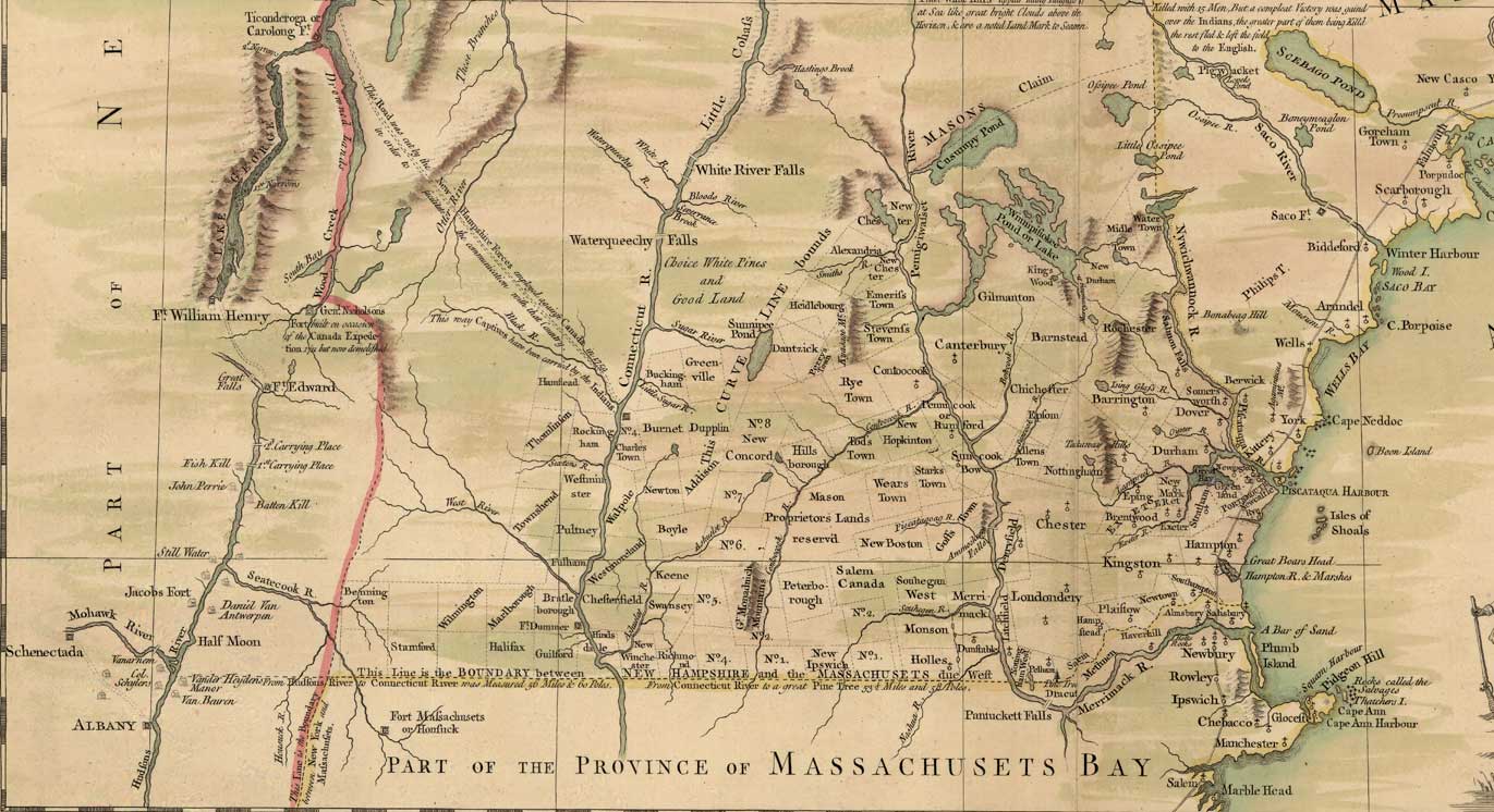
 They say things are darkest before the dawn. Friday offered a new twist on that, with the rain hardest before Mother Nature rewarded us with a rainbow. I’d paid my penance for the view, while those heading eastbound had the reward (the better view) first only to drive into the storm afterwards. There’s probably an analogy to explore there, but it’s best to be on my way.


 The lower part of the Cascadilla Gorge Trail begins Treman Triangle, a small triangular shaped park named after Robert H. Treman, a local gentleman and successful Ithaca businessman who, along with fellow trustee Henry Woodward Sackett donated this Gorge to Cornell University. But Treman didn’t stop with this gorge. He also donated the land around Buttermilk Falls State Park and the park named after him, the Robert H. Treman State Park. This is the type of wealthy guy I admire: make a lot of money and then do something good with it. These were his time capsules, preserving the things he loved about Ithaca so that they might be enjoyed by generations long after he’s gone. He’s remembered far more for the land he donated than for his success in business. Isn’t that a greater success story than what he had accumulated in his bank account?
