I have a fascination with maps, and especially old maps, that dates back to when I was a kid tracing the route that we would take on family vacations. When I started driving myself around I bought maps to help me navigate first the town I lived in and later New England and points beyond. As a hiker I’d plot out where I’d be able to refill water bottles and camp for the night. Maps were essential for navigating the world.
Today GPS has stolen the magic of maps for everyday use in getting from point A to point B, but they can’t completely replace them. I still plot out trips on Google Maps to plan the most efficient route. I still love a good map; evident in the title of this blog. So it was a delight to find a gem of an old map from 1761 created by Joseph Blanchard and Samuel Langdon. This map has wonderfully random reference points like “From Connecticut River to a Great Pine Tree” and “This way captives have been carried by the Indians”. This is a map you can fall in love with.
 Joseph Blanchard was born in the Nashua area and served as a Colonel during the French and Indian War. He teamed with Samuel Langdon to create this map, which was published after Blanchard’s death. It’s an amazing time capsule that highlights some contentious early days in our colonial history. For me, the part of the map I love the most is in the present-day Plainfield/Montcalm area where the map designers noted “choice white pines and good land”. A name like Montcalm jumps out if you’re talking about the French & Indian War, but apparently it’s not what the selectmen in that town were striving for when they named it.
If you search online you’ll find there are a couple of versions of the map available for viewing. The black and white version I have above, and a color version, a portion of which I show below. The towns have mostly remained the same, with a few splitting into a multiple towns along the way. The rivers are fairly accurate, which is notable since these were the superhighways of the day. The map reaches as far west as Schenectady and as for North as Quebec. This territory was ground zero in the French and Indian War, and the wars with the French that preceded it. It would be important again during the early years of the Revolutionary War. I’ve had the opportunity to travel most of this region over the years, and spend a lot of time writing about it in this blog. So this map put a spell on me that I haven’t shaken loose from just yet.
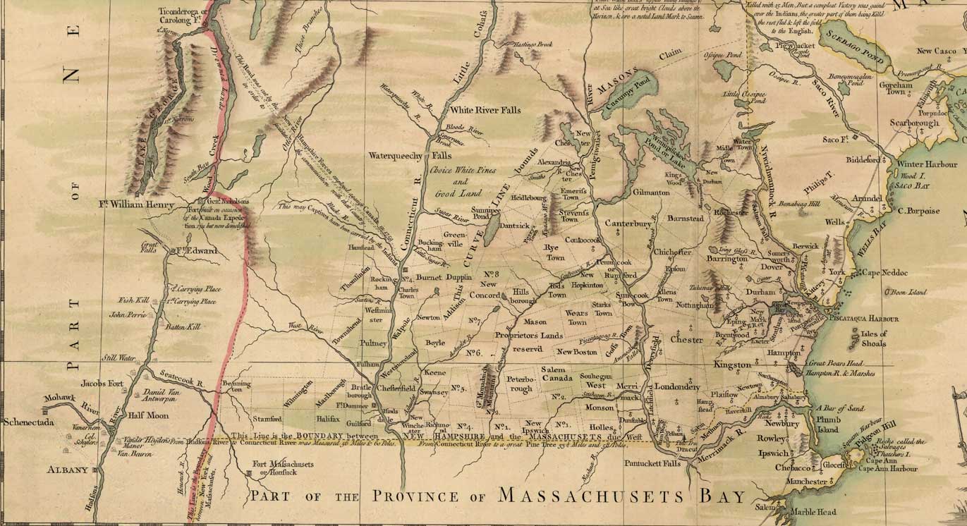
“The paradox of mapmaking… is that as soon as you begin shrinking a geography down to usable size, you necessarily are forced to misrepresent it. By making choices about what to include and what to leave out, you change the map from a document faithfully documenting an area to one furthering a particular point of view.” – Michael Blanding, The Map Thief
Blanchard and Langdon created a map that clearly furthered a point of view, lending credence to Blanding’s observation. The history buff in me delights in reading it. Would it look the same if a Native American warrior had drawn it? Surely not. But the map no longer serves the purpose of furthering a point of view as much as it creates a snapshot of what the map’s creators were thinking at the time. Either way it’s a fascinating dance across time.

Leave a comment